Introduction
The idea of agro-urbanism – city farms – has its roots
in modern concepts of utopian cities, the concepts which
were based on bringing the natural environment closer to
the city environment in order to create a system of an
ecological town. This concept, which originated from the
idea of garden cities by Ebenezer Howard and was then
developed by modernists at the beginning of the 20
th
cen-
tury (Gonzales del Castillo, Le Corbusier, Frank Lloyd
Wright, Ludwig Hilberseimer
1
[1]), was enriched in the
1960
s
by Richard Register from Berkeley in the USA. The
main purpose of the eco-city proposed by him was a ci -
vilisation reconstruction and a return to the life in har-
mony with nature. Ecological concepts of city space in
Europe were realised in the following designs: Florids-
dorf in Vienna (Michael Szyszkowitz and Karla Kowal-
ski), Jarna in the vicinity of Sztokholmu (design by Erik
As um ssen) and in the town of Alphen Vaan Dell Rijn
(design cooperation Lucien Kroll). In the eco-city, space
1
According to Charles Waldheim, these tendencies appear in three
unrealised designs which suggest decentralised and agrarian urban plan-
ning, i.e. Frank Lloyd Wright “Broadacre City” (1934/1935), Ludwig
Hilberseimer “New Regional Pattern” (1945/1949) and Andrea Branzi
“Agronica” (1993/1994) as well as “Territory for the New Eco nomy”
(1999). These designs considered as a whole represent a symbiosis of
agricultural production and a city. Each of these designs suggests deep
changes in the city structures – radical decentralisation and a connection
with the landscape. The city becomes a suburbia which is smoothly
transformed into the village landscape. Taking into account the modern
interest in city farming, these propositions offer attractive alternatives
for a historical model of a city [1].
2014
1(37)
DOI: 10.5277/arc140107
Bogusław Wowrzeczka*
Agropolis. Część I. Nowa Atlantyda
Agropolis. Part I. New Atlantis
Wprowadzenie
Idea agrourbanistyki – farm miejskich – ma swoje
korzenie we współczesnych koncepcjach miast utopii,
któ rych fundamentem jest zbliżenie środowiska natu-
ralnego i miejskiego w celu stworzenia systemu miasta
eko logicznego. Koncepcja ta, wywodząca się z idei mias-
ta-ogrodu Ebenezera Howarda, rozwinięta przez mo der-
nis tów na początku XX w. (Gonzales del Castillo, Le Cor-
busier, Frank Lloyd Wright, Ludwig Hilberseimer
1
[1]),
została wzbogacona w latach 60. XX w. przez Ri charda
Registera z Berkeley w USA. Głównym celem za pro po-
nowanego przez niego ecocity była odbudowa cywilizacji
i powrót do życia zgodnego z naturą. Kon cep cje ekolo-
giczne przestrzeni miejskiej w Europie zostały zreali zo-
wane w projektach: Floridsdorf w Wiedniu (Mi chael Szysz-
kowitz
i Karla Kowalski), Jarna w okolicach Sztok holmu
(projekt Erik Asumssen) oraz w miasteczku Alphen Vaan
Dell Rijn (współpraca projektowa Lucien Kroll). W ec o-
* Wydział Architektury Politechniki Wrocławskiej/Faculty of
Architecture, Wrocław University of Technology.
1
Charles Waldheim pisze, że tendencje te pojawiają się w trzech
niezrealizowanych projektach proponujących zdecentralizowaną, agrar-
ną urbanistykę: Frank Lloyd Wright „Broadacre City” (1934/1935),
Ludwig Hilberseimer „New Regional Pattern” (1945/1949) oraz Andrea
Branzi „Agronica” (1993/1994) i „Territory for the New Economy”
(1999). Projekty te, traktowane łącznie, przedstawiają symbiozę produk-
cji rolnej i miasta. Każdy z tych projektów proponuje głębokie zmiany
struktury miasta – radykalną decentralizację i powiązanie z krajobra-
zem. Miasto staje się suburbią płynnie przekształcającą się w krajobraz
wiejski. Biorąc pod uwagę współczesne zainteresowanie rolnictwem
miejskim, te propozycje oferują atrakcyjne alternatywy dla historycz-
nego wzorca miasta [1].

68 Bogusław Wowrzeczka
is treated in a holistic manner – as a mutually connected
ecosystem [2]. Apart from integrating workplaces, places
of residence and recreation, a search for new city space is
aimed at building autonomous complexes which are eco-
logically and socially sustainable [3].
At the beginning of the 1970
s
, the notion of a “mega-
city”
2
appeared which referred to the suburbs of Rio de
Janeiro, the so called favelas (shanty towns) – sponta-
neous city “villages” which were built in the far suburbs
of cities. In megacities the traditional forms of Green
Belts were replaced by spontaneously built large “village-
city” hybrid spheres which at present constitute a charac-
teristic feature of all big cities and shall play a significant
role in a city of the future
3
[5].
Agro-urbanism
The 19
th
and the beginning of the 20
th
century brought
an exuberant development of cities which was the result
of economic and social changes such as the industrial
deve lopment in cities and an increase in the number of
people who, due to occurring agrarian reforms, massively
left villages in search of jobs. Intensification of the devel-
opment as well as the increasing height of buildings
resulted in overpopulation and deterioration in sanitary
conditions of life in cities. Against this background, some
new concepts of forming the functional and spatial struc-
ture of a city appeared in urban planning. It became a pa -
ra digm
to zone a place into industrial and residential areas.
As a consequence, the intensity of developing residential
areas was reduced, whereas the role of green areas in the
development gained great significance. In a newly emerg-
ing face of urban planning, the concepts of utopian cities
played a significant role, in particular Howard’s model of
a garden city described in the book Tomorrow: a Peaceful
Path to Real Reform in 1898 and its slightly modified ver-
sion in Garden Cities of Tomorrow
4
published in 1902 [6].
In the 20
th
century modernists introduced the notion of
counterurbanisation as a new concept of a “city in the
park”
5
. It was characterised by a scattered residential de -
2
This notion was introduced by Janice Perlman PhD from
Berkeley and in this way she defined the suburbs of Rio de Janeiro – the
so called favelas [4].
3
The process of incorporating village areas into cities is relatively
slow and is connected with the development of industry, car and railway
transport as well as with modern systems of public transportation.
Aristotle describes a city as the aggregation of subsequent villages
incorporated into the area of a city [5].
4
City Garden: it was usually designed for 32 thousand inhabitants.
The unit was based on the circle plan which was divided into six identi-
cal parts by the main streets. The particular zones had their functions,
e.g. services, residential, recreational. The whole unit was surrounded
by a ring of agricultural terrains and designed around a central park
which was 900 metres in diameter where public buildings were situated.
According to the assumptions, 35 m
2
of public green areas fell per one
inhabitant, while about 200 m
2
fell to one house. On a narrow belt of the
area that surrounded residential districts, factories and warehouses
were supposed to be situated. It reflected an objection to a bedroom
character of suburbs [6].
5
The Athens Charter, which was published in 1933, proclaimed
that architecture is to serve man and follow humanistic values. The
city przestrzeń traktowana jest w sposób całościowy –
jako wzajemnie powiązany ekosystem [2]. Oprócz inte-
gracji miejsc pracy, zamieszkania i rekreacji poszukiwa-
nia nowej przestrzeni miejskiej zmierzają w kierunku
stwo rzenia autonomicznych kompleksów zrów no wa żo-
nych ekologicznie i społecznie [3].
Na początku lat 70. XX w. pojawiło się pojęcie „me -
gacity”
2
, które odnosiło się do przedmieść Rio de Janeiro,
tzw. faveli – spontanicznych „wiosek” miejskich zbudo wa-
nych na obrzeżach miasta. W megacity tradycyjne for my
pierścieni zieleni, tzw. Green Belt, zastąpiły sponta nicz-
nie zabudowane, rozległe hybrydowe strefy „wiejsko-
-miejskie”, które obecnie stanowią cechę cha rak te rys-
tyczną wszystkich wielkich miast i będą odgrywać istotną
rolę w mieście przyszłości
3
[5].
Agrourbanistyka
Wiek XIX i początek XX przyniosły żywiołowy roz-
wój miast, będący skutkiem zachodzących przemian
gospodarczych i społecznych: rozwoju przemysłu w mia-
stach i wzrostu liczby ludności, która z powodu dokonu-
jących się reform agrarnych masowo opuszczała wieś
w po szukiwaniu pracy. Intensyfikacja zabudowy i wzrost
jej wysokości doprowadziły do przeludnienia i pogorsze-
nia warunków sanitarnych życia w miastach. Na tym tle
w urbanistyce pojawiły się nowe koncepcje kształtowania
struktury funkcjonalno-przestrzennej miasta. Paradyg-
matem stało się strefowanie na tereny przemysłowe
i miesz kaniowe. W konsekwencji intensywność zabudo-
wy terenów mieszkaniowych uległa redukcji, a rola tere-
nów zielonych w zabudowie nabrała istotnego znaczenia.
W rodzącej się nowej urbanistyce znaczącą rolę odegrały
koncepcje miast utopijnych, a zwłaszcza model miasta-
-ogrodu Howarda opisany w książce Tomorrow: a Peace-
ful Path to Real Reform z 1898 r. i nieco zmodyfikowany
w wydanej w 1902 r. Garden Cities of Tomorrow
4
[6].
W XX w. moderniści wprowadzili pojęcie dezurbani-
zacji jako nową koncepcję „miasta w parku”
5
. Charak te-
2
Pojęcie to wprowadziła dr Janice Perlman z Berkeley, określając
w ten sposób przedmieścia Rio de Janerio – tzw. favele [4].
3
Proces włączania terenów wiejskich do miast jest stosunkowo
po wolny i wiąże się z rozwojem przemysłu, transportu samochodowe-
go, kolejowego i nowoczesnych systemów komunikacji miejskiej. Arys-
to teles opisuje miasto jako agregację kolejnych wsi włączanych w ob -
szar miasta [5].
4
Miasto-ogród: Zazwyczaj przeznaczone było dla 32 tysięcy miesz-
kańców. Jednostka została oparta na planie koła, podzielonego głów-
nymi ulicami na sześć jednakowych części. Poszczególne strefy miały
przypisane funkcje, np.: usługowe, mieszkaniowe, rekreacyjne. Całość
była skupiona wokół centralnego parku o średnicy około 900 m,
w którym znajdowały się budynki publiczne, i otoczona wieńcem te -
renów rolniczych. Według założeń na jednego mieszkańca przypadało
35 m
2
zieleni publicznej, a na jeden dom około 200 m
2
. Na wąskim pas-
ku terenu, który otaczał dzielnice mieszkaniowe, usytuowane miały być
zakłady przemysłowe i magazyny. Odzwierciedlało to sprzeciw wobec
sypialnianego charakteru przedmieść [6].
5
Uchwalona w 1933 r. Karta Ateńska głosiła, że architektura ma
służyć człowiekowi, kierować się humanistycznymi wartościami. Po stu-
lat zapewnienia słońca, przestrzeni i zieleni mieszkańcom stanowił pa -
ra dygmat nowej urbanistyki. Miasta miały być zintegrowane z ota cza ją-

Agropolis. Część I. Nowa Atlantyda /Agropolis. Part I. New Atlantis 69
ve lopment which was integrated with natural city green
areas and the surrounding landscape
6
.
New ecological ideas in European urban planning
appeared at the end of the 1950
s 7
and have been continued
in designs of eco-cities based on sustainable environment
principles
8
[5], [9]. Modern eco-urban planning focuses
on the following three main groups of issues:
– the first one refers to designs of new urban structures
which are based on the symbiosis of a city tissue with
agricultural production: agro-towns, mega-structures –
permacultures, self-sufficient and biomimetic city com-
plexes, partially realised experimentally in the framework
of various Expo exhibitions [10];
– the second one comprises processes of revitalisation
of the existing urban tissue on the basis of sustainable
development, transformation processes consisting in,
inter alia, creating vertical nets and horizontal farms and
gardens of different scales and a diverse level of produc-
tion technology advancement;
– the third one constitutes the issues referring to the
control of spontaneous agrarian processes of cities [11] –
creating agricultural areas in cities as a result of village
people’s migration to cities (e.g. favelas, slums) and their
transformations into planned agro-urban structures.
Utopian designs of cities
9
which are self-sufficient in
the range of food production and energy production were
created on the basis of ecological urban planning [2], [4].
Designs of mega-structures, which constituted inde pen-
dent urban units with a diverse scale and level of technolo-
gical and functional complexity, were representative for
this trend in modern urban planning. An innovative
approach to the solution of a self-sufficiency problem is
presented by experimental designs produced within the
framework of research grants, architectural and urban
com petitions and studio designs which are discussed
below.
Architects from Arphenotype Studio designed a mega-
structure which presented a closed food-energy system –
floating permaculture. According to the design, it is a net
of floating farms – mega-structures, which deliver food to
postulate, which provided the sunlight, space and green areas, consti-
tuted a paradigm of new urban planning. Cities were to be integrated
with the surrounding landscape, safe and socially sustainable, i.e. they
were to provide everybody with access to entertainment, culture, rest
and services. Garden cities, folk parks, bathing areas and libraries were
to realise the idea of people living in harmony with nature on the one
hand, while on the other hand, they were to satisfy their needs in the
range of culture.
6
Bruno Taut was a remarkable representative of this trend in urban
planning at that time. He designed the following cities in green: Garten stadt
Falkenberg, Schillerpark, Britz-Hufeisensiedlung and Carl Legien [7].
7
They were presented at the international construction exhibitions
in Germany which were organised by Werkbund: “City of Tomorrow” in
1959, “State + Water = Golden Earth” in 1967 and PROFITOPOLIS in
1971 [8].
8
Masdar – a design by Foster Office + Partners, Ras al Khaimah
– a design by Rem Koolhaas, Logroño Montecorvo – a design by
MVRDV and GRAS Studio, Dongtan – a design by Arup Company,
Nature City, Keizer, Oregon – a design by WORKac Studio [9].
9
Concepts of cities which constitute a continuation of metabolists’
idea from the 1960
s
[2], [4].
ryzowała się ona rozproszoną zabudową mieszkaniową
zintegrowaną z naturalną zielenią miejską i otaczającym
krajobrazem
6
.
Nowe idee ekologiczne w urbanistyce europejskiej
pojawiły się pod koniec lat 50. XX w.
7
i są kontynuowane
w projektach ekomiast opartych na zasadach środowiska
zrównoważonego
8
[5], [9]. Współczesna ekourbanistyka
skupia się na trzech głównych grupach zagadnień:
– pierwsza dotyczy projektowania nowych struktur
urbanistycznych opartych na symbiozie tkanki miejskiej
z pro dukcją rolniczą: agromiasta, megastruktury – perma-
kultury, zespoły miejskie samowystarczalne i biomime-
tycz ne, częściowo realizowane eksperymentalnie w ra -
mach różnych wystaw Expo [10];
– druga grupa obejmuje procesy rewitalizacji ist nie-
jącej tkanki urbanistycznej w oparciu o zasady zrówno-
ważonego rozwoju, procesy przekształceń polegające
między innymi na tworzeniu sieci wertykalnych i hory-
zontalnych farm i ogrodów o różnej skali i zróżnicowa-
nym stopniu zaawansowania technologii produkcji;
– trzeci nurt to zagadnienia dotyczące kontrolowania
spontanicznych procesów
agraryzacji miast [11] – tworze-
nia terenów rolniczych w miastach w wyniku migracji
ludności wiejskiej do miast (np. favele, slumsy) oraz ich
przekształcania w planowe struktury agrourbanistyczne.
Na bazie urbanistyki ekologicznej powstały projekty
uto pijne miast
9
samowystarczalnych w zakresie produkcji
żywności i produkcji energii [2], [4]. Reprezentatywne
dla tego kierunku współczesnej urbanistyki są projekty
me gastruktur stanowiących niezależne jednostki urba -
nistyczne o zróżnicowanej skali oraz stopniu złożoności
funkcjonalnej i technologicznej. Nowatorskie podejście
do rozwiązywania problemu samowystarczalności pre-
zentują omówione poniżej eksperymentalne projekty opra-
co wane w ramach grantów badawczych, konkursów ar -
chi tektoniczno-urbanistycznych i projektów studialnych.
Architekci z pracowni Arphenotype zaprojektowali
megastrukturę, która tworzy zamknięty system żywnoś-
ciowo-energetyczny – permakulturę pływającą. Według
projektu to sieć pływających farm – megastruktur, które
zaopatrują w żywność miasta w Europie [12]. Mimo futu-
rystycznego kształtu propozycja ma swoje realne prze-
cym krajobrazem naturalnym, bezpieczne i społecznie zrównoważone:
zapewniać wszystkim dostęp do rozrywki, kultury, wypoczynku i usług.
Miasta-ogrody, parki ludowe, kąpieliska, biblioteki miały z jednej stro-
ny realizować ideę życia ludzi w zgodzie z naturą, z drugiej zaś spełniać
ich potrzeby w zakresie kultury.
6
Wybitnym przedstawicielem tego nurtu w ówczesnej urbanistyce
był Bruno Taut. Zaprojektował on miasta w zieleni: Gartenstadt Fal ken-
berg, Schillerpark, Britz-Hufeisensiedlung i Carl Legien [7].
7
Były prezentowane na międzynarodowych wystawach budow-
lanych w Niemczech organizowanych przez Werkbund: „Miasto Jutra”
z 1959 r., „Kraj + Woda = Złota Ziemia” z 1967 r. i PROFITOPOLIS
z 1971 [8].
8
Masdar – projekt biura Foster + Partners, Ras al Khaimah – pro-
jekt Rema Koolhaasa, Logroño Montecorvo – projekt pracowni
MVRDV i GRAS, Dongtan – projekt firmy Arup, Nature City, Keizer,
Oregon – projekt pracowni WORKac [9].
9
Koncepcje miast stanowiące kontynuację idei metabolistów z lat
60. XX w. [2], [4].

70 Bogusław Wowrzeczka
cities in Europe [12]. Apart from its futuristic shape, this
design has its practical premises, i.e. nowadays, the pro-
duced food before it reaches the consumer, covers a dis-
tance of about 1000 km, which results in fuel consump-
tion and air pollution with carbon dioxide. Therefore, it is
quite reasonable to develop a self-sufficient urban system
in which inhabitants shall have direct access to the pro-
duced food. The system, which was offered by Dutch
architects, significantly lowers fresh water consumption
in agriculture – at present, it is at a level of 70% of overall
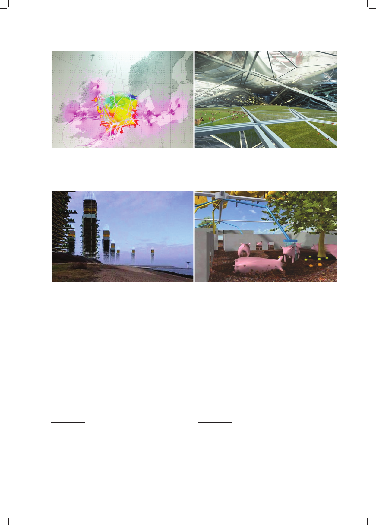
water consumption (Fig. 1).
A crucial event in promoting a symbiosis of agricul-
tural production with a city is the research initiative com-
bined with a competition and an exhibition of designs
called “Carrot City”. The proposals of “Carrot City”
10
pre sent a wide range of modern design concepts referring
to the issues of agricultural production as a territorial
domain of a city [13], [15].
At “Carrot City” exhibition a novel and at the same
time controversial design by MVRDV Architectural
Studio named “Pig City” was presented [16]. The design
was produced in 2001 and extensively discussed in the
Ne ther lands.
“Pig City” consists of 76 towers, each of which is circa
190 meters in height
11
. Animals are raised on an area of
87 m
2
but they have additional balconies with animal
runs. Slaughterhouses are on the first floor where pigs are
transported by means of goods lifts. The service is fully
automatic and does not require involving people. Addi-
tionally, small fish farms for the needs of inhabitants were
de signed on the roofs of high-rises. Moreover, in each
tower there is a waste recycling plant and a biogas con-
tainer to meet the electric energy needs of the city. In
order to lower costs of transport, 44 towers were situated
in harbour zones of the western Netherlands, whereas the
other ones were located all over the country and surround-
ed with agricultural areas. “Pig City” offers solutions to
problems of massive pig rearing, i.e. centralisation allows
saving time, money and first of all farmlands in the Ne -
ther lands (Fig. 2).
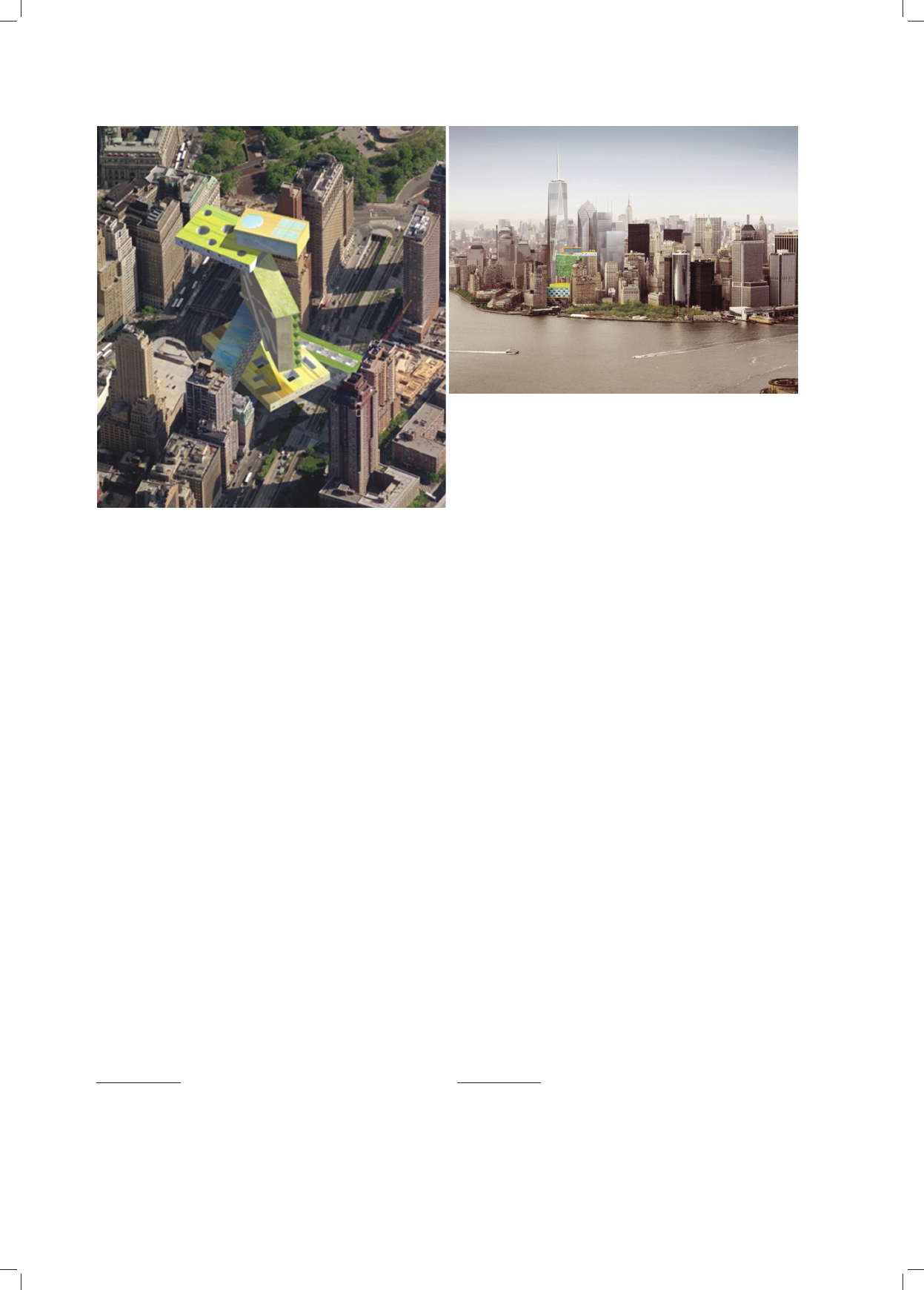
A design called “Plug Out”, which is located in the
area of Lower Manhattan in New York, is a vertical farm
design in the existing urban surroundings. A building in
the form of a multifunctional mega-structure is not only
a city farm but also an important element of the ecological
infrastructure of the whole city and its “urban dialysis”.
The tower constitutes a recycling and energy production
plant. Rainwater is used in toilets, in the laundry and fish
farms. Greywater is purified and reused to irrigate hydro-
ponic crops (Fig. 3).
10
The initiative of “Carrot City” is aimed at popularising the idea
and knowledge about the best practices in the city agriculture. Con-
sequently, a newly set up website contains a comprehensive repository
of “Carrot City” initiative and is to serve as a research tool for everyone
who is interested in connections between city designing and food pro-
duction in modern cities [13], [14].
11
“Pig City” is a conventional name because it refers to a complex
of tower structures located in the whole territory of the Netherlands and
connected with one another in a spatial and economic network.
słanki: obecnie wyprodukowana żywność, zanim trafi do
konsumenta, przemierza średnio około 1000 km, co skut-
kuje zużyciem paliwa i zanieczyszczeniem powietrza
dwutlenkiem węgla. Logiczne zatem jest stworzenie sa -
mo wystarczalnego systemu urbanistycznego, w którym
mieszkańcy mają bezpośredni dostęp do produkowanej
żywności. System proponowany przez holenderskich
projektantów zmniejsza znacząco zużycie słodkiej wody
w rolnictwie – obecnie kształtuje się ono na poziomie
70% ogólnego zużycia wody (il. 1).
Istotnym wydarzeniem promowania symbiozy produk-
cji rolnej z miastem jest inicjatywa badawcza połączona
z konkursem i wystawą projektów pod nazwą „Carrot
City”. Propozycje „Carrot City”
10
przedstawiają szerokie
spektrum współczesnych koncepcji projektowych odno-
szących się do zagadnienia produkcji rolnej jako domeny
terytorialnej miasta [13], [15].
Na wystawie „Carrot City” prezentowany był nowa-
torski i zarazem kontrowersyjny projekt pod nazwą „Pig
City” – „Miasto Świń”, duńskiej pracowni architekto-
nicznej MVRDV [16]. Projekt powstał w 2001 r. i był
szeroko dy skutowany w Holandii.
„Miasto Świń” to 76 wież, każda około 190 m wy so-
koś ci
11
. Zwierzęta są hodowane na powierzchni 87 m
2
,
ale mają dodatkowo balkony z wybiegiem. Ubojnie znaj-
dują się na pierwszym piętrze, gdzie świnie są trans-
portowa ne windami towarowymi. Obsługa jest w pełni
zauto ma ty zowana i nie wymaga angażowania ludzi. Na
dachach wieżowców zaprojektowano dodatkowo małe
hodowle ryb na potrzeby mieszkańców. Ponadto w każdej
wieży istnieje zakład recyklingu odpadów oraz zbiornik
bio gazu do zaspokojenia potrzeb miasta w energię elek-
tryczną. Aby zmniejszyć koszty transportu, 44 wieże zlo-
ka li zo wano w strefach portowych zachodniej Holan dii,
a po zo s tałe w pobliżu innych miast wewnątrz kraju, oto-
czo nych terenami rolniczymi. „Pig City” proponuje roz-
wią zanie problemów masowej hodowli trzody chlewnej:
centrali za cja pozwala zaoszczędzić czas, pieniądze,
a prze de wszystkim grunty rolne w Holandii (il. 2).
Projektem farmy wertykalnej w istniejącym otoczeniu
urbanistycznym jest projekt o nazwie „Plug Out”, zloka-
lizowany na obszarze Dolnego Manhattanu w Nowym
Jorku. Budynek w formie wielofunkcyjnej megastruktury
jest nie tylko farmą miejską, ale również ważnym ele-
mentem infrastruktury ekologicznej całego miasta, jego
„urbanistycznej dializy”. Wieża stanowi fabrykę recyklin-
gu i produkcji energii. Woda deszczowa jest wyko rzys-
tywana do toalet, w pralni i w hodowli ryb. Szara woda
jest oczyszczana i ponownie wprowadzana do obiegu do
na wad nia nia upraw hydroponicznych (il. 3).
10
Inicjatywa „Carrot City” ma na celu rozpowszechnianie idei
i wie dzy o najlepszych praktykach w miejskim rolnictwie. W związku
z tym założona strona internetowa zawiera obszerne repozytorium ini-
cja tywy „Carrot City” i ma służyć jako narzędzie badawcze dla każ de-
go, kto interesuje się powiązaniami między projektowaniem miasta
i produkcją żywności we współczesnych miastach [13], [14].
11
„Miasto Świń” jest określeniem umownym, ponieważ odnosi się
do zbioru struktur wieżowych zlokalizowanych na całym terytorium
Ho landii i połączonych ze sobą w sieć przestrzenno-gospodarczą.
Agropolis. Część I. Nowa Atlantyda /Agropolis. Part I. New Atlantis 71
Il. 1. „Floating Permaculture” pracowni Arphenotype to żywy organizm, autonomiczny system urbanistyczny,
w skali lokalnej, krajowej i międzynarodowej [12]
Fig. 1. “Floating Permaculture” by Arphenotype Studio is a living organism, an autonomous urban system, on a local, national and international scale [12]
Il. 2. „Pig City”, projekt pracowni MVRDV, to wertykalne farmy zaspokajające potrzeby produkcji mięsa dla całej Holandii i na eksport [16]
Fig. 2. “Pig City”, a design by MVRDV Studio presents vertical farms that meet the meat production needs for the whole of Netherlands and for export [16]
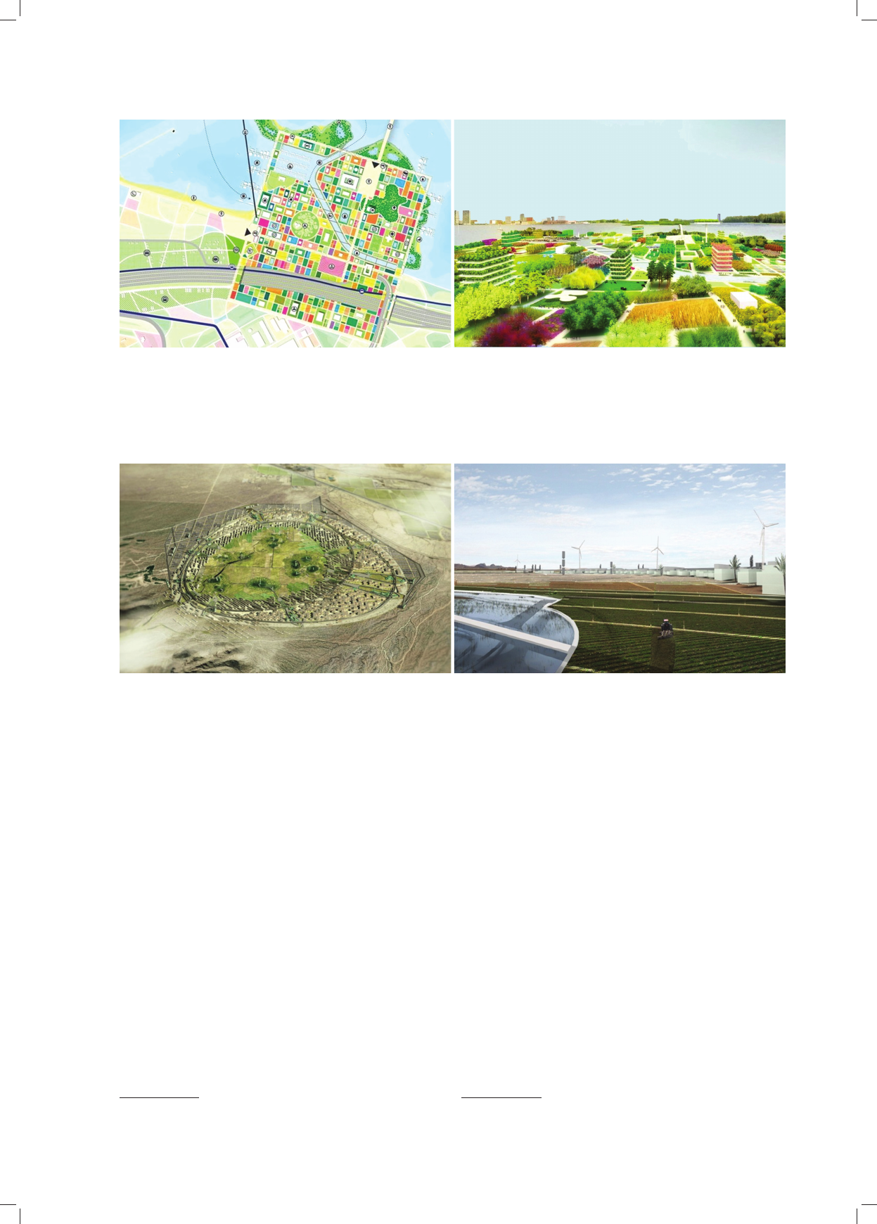
In 2012 MVRDV on the basis of previous designs
12
prepared a concept of land development for the interna-
tional garden exhibition Floriade which is going to take
place in Almere in the Netherlands in 2022. Instead of
creating contemporary Expo areas, MVRDV designed an
“ideal city” which will be a green extension of the Almere
centre in the future. Using the previous research conduc-
ted in designs of Almere Oosterwold
13
and Almere 2030
Master Plan, MVRDV proposed a garden tapestry on the
plan of squares on an area of 45 hectares. Each square-
block will have different plants. The new green urban
complex is supposed to be a place which produces food
12
These are urban designs of the spatial development of Almere [18].
13
In the design of Almere Oosterworld, MVRDV prepared a revo-
lutionary strategy of the city development due to the use of city agricul-
ture. More than 50% of the area of the designed city part were to be
covered by city farms producing food for the city. Formally, the design
refers to a square form which was applied in ideal city concepts. The
design on an area of 43 km
2
provides, among other things, 15 000 flats,
26 000 workplaces, 135 hectares for companies, 200 000 m
2
for offices,
400 hectares of a new landscape park. Almere – Floriade refers to this
design
[18]
.
W 2012 r. MVRDV na bazie wcześniejszych projek-
tów
12
przygotowała koncepcję zagospodarowania terenu
dla międzynarodowej wystawy ogrodniczej Floriade, któ-
ra odbędzie się w Almere w Holandii w 2022 r. Zamiast
tworzyć tymczasowe tereny Expo, MVRDV zapro jek to-
wało „idealne miasto”, które w przyszłości będzie zielo-
nym rozszerzeniem centrum Almere. Opierając się na
wcześ niejszych badaniach w projektach Almere Ooster-
wold
13
i Almere 2030 Master Plan, MVRDV zapropo no-
wało na powierzchni 45 ha gobelin ogrodów na planie
kwa dratów. Każdy kwadrat-blok będzie poświęcony in -
nej roślinności. Nowy zielony zespół urbanistyczny ma
12
Są to projekty urbanistyczne rozwoju przestrzennego Almere [18].
13
W projekcie Almere Oosterworld MVRDV przygotowała re wo-
lucyjną strategię rozwoju miasta dzięki wykorzystaniu rolnictwa miej -
skiego. Przeszło 50% powierzchni projektowanej części miasta prze-
znaczo no na farmy miejskie produkujące na jego potrzeby. Projekt pod
wzglę dem formalnym nawiązuje do stosowanej w koncepcjach miast
idealnych formy kwadratu. Projekt na powierzchni 43 km
2
przewiduje
m.in. 15 000 mieszkań, 26 000 miejsc pracy, 135 ha dla firm, 200 000 m
2
biur, 400 ha nowego parku krajobrazu. Do tego projektu na wiązuje pro-
jekt Almere – Floriade
[18]
.
72 Bogusław Wowrzeczka
and energy and reflects possibilities of enriching the city
environment on the basis of the symbiosis between man
and nature
14
(Fig. 4).
“Autonomous City” is a design of a self-sufficient city
on the desert in Arizona. It assumes that the central part in
the city structure is occupied by farms which produce
food for inhabitants and that all wastes that are produced
in the city are utilised and at the same time energy is
obtained from them [19]. A significant element of the city
functioning is the principle of balance between simple
and advanced technologies and this principle is imple-
mented on all scales of the design, i.e. the city as a whole,
the city complex, a building with the application of pas-
sive and active systems that cooperate with one another.
A number of autonomous cities can form a federation and
in this way replace the existing inefficient city structures.
The design is one of the possible scenarios of the city struc-
ture development in the future and it is very interesting
because it offers the location of a city in an extreme envi-
ronment by adapting solutions to the changing climate con-
ditions during the year. Formally, it constitutes a continua-
tion of the central form of a garden city by Howard (Fig. 5).
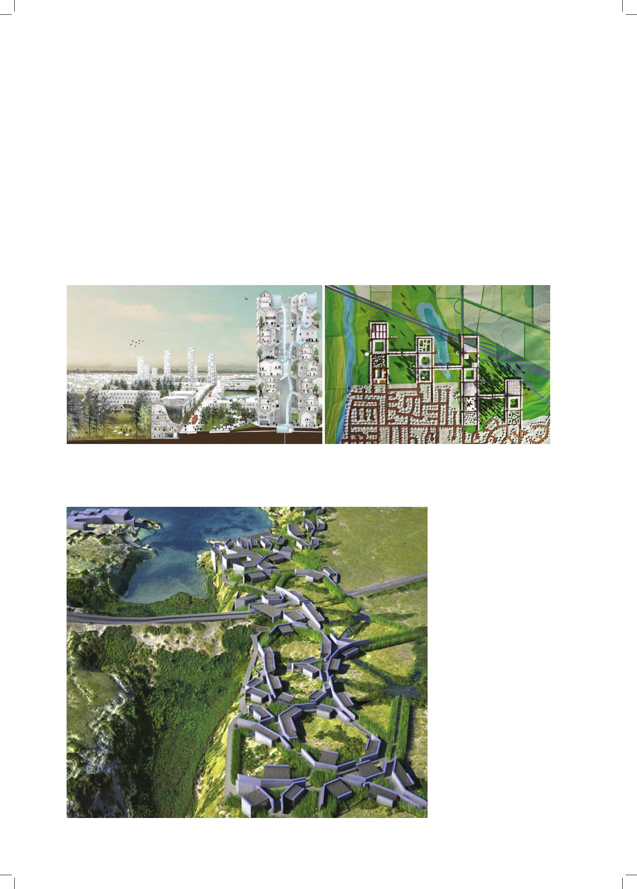
WORKac Architectural Studio at the exhibition
MOMA in New York – “Foreclosed: Rehousing the Ame-
rican Dream”
15
presented a new idea of the American sub-
urbia as a continuation of Howard’s garden city idea.
“Nature City” design in Salem Keizer in Oregon in the
USA constitutes a combination of the city development
14
“Cité Idéale” program comprises: a viewing tower, a green exhibi-
tion with residential houses (22 000 m
2
/115 houses), a hotel (30 000 m
2
),
a university (10 000 m
2
), a conference centre (12 000 m
2
), various Expo
pavilions (25 000 m
2
), intelligent green houses (4000 m
2
), a nursing
home (3000 m
2
), Expo square, a marina, a forest, an amphitheatre,
a cam ping site and other facilities (25 000 m
2
)
[18]
.
15
The exhibition took place in New York in May 2011 [8].
być miejscem, które produkuje żywność i energię oraz od -
zwierciedla możliwości wzbogacenia środowiska miejs-
kiego w oparciu o symbiozę człowieka z naturą
14
(il. 4).
„Autonomous City” jest projektem samowystarczal-
nego miasta zrealizowanego na pustyni w Arizonie. Za -
kła da, że centralne miejsce w strukturze miasta zajmują
te reny farm produkujące na potrzeby mieszkańców oraz
że następuje całkowita utylizacja odpadów wytwarza-
nych w mieście przy równoczesnym pozyskiwaniu z ich
uty lizacji energii [19]. Istotnym elementem funkcjo no-
wania miasta jest zasada równowagi między prostą i za -
awansowaną technologią oraz wprowadzanie tej zasady
we wszystkich skalach projektu: miasta jako całości,
zespołu miejskiego, budynku przy zastosowaniu syste-
mów pasywnych i aktywnych współpracujących ze sobą.
Szereg miast autonomicznych może tworzyć federację,
zastępując istniejące niewydolne struktury miejskie. Pro-
jekt jest jednym z możliwych scenariuszy rozwoju struk-
tur miejskich w przyszłości interesującym dlatego, że
pro ponuje lokalizację miasta w środowisku ekstremal-
nym przy dostosowaniu rozwiązań do zmieniających się
w ciągu roku warunków klimatycznych. Pod względem
formalnym stanowi kontynuację centralnej formy miasta-
-ogrodu Howarda (il. 5).
Pracownia projektowa WORKac na wystawie MOMA
w Nowym Jorku – „Foreclosed: Rehousing the American
Dream”
15
przedstawiła nową ideę amerykańskich subur-
biów jako kontynuację idei miasta-ogrodu Howarda.
14
Program „Cité Idéale” obejmuje: wieżę widokową, wystawę zie-
le ni z domami mieszkalnymi (22 000 m
2
/115 domów), hotel (30 000 m
2
),
uniwersytet (10 000 m
2
), centrum konferencyjne (12 000 m
2
), różne
pawilony Expo (25 000 m
2
), inteligentne zielone domy (4000 m
2
), dom
opieki (3000 m
2
), plac Expo, marinę, las, amfiteatr, camping i inne
obiekty (25 000 m
2
)
[18]
.
15
Wystawa odbyła się w maju 2011 r. w Nowym Jorku [8].
Il. 3. „Plug Out” – koncepcja samowystarczalnego ekologicznego
budynku na Manhattanie [17]
Fig. 3. “Plug Out” – a concept of the ecological self-sufficient building
in Manhattan [17]
Agropolis. Część I. Nowa Atlantyda /Agropolis. Part I. New Atlantis 73
with green areas and gardens which are at the same time
agricultural production facilities. The complex which is
22.5 hectares in area is supposed to have 13 000 inhabitants
and provide them with direct access to gardens and or -
chards. An increase in the development intensity is an attempt
to oppose the tradition of low suburban development and
at the same time to protect agricultural areas (Fig. 6).
A research design of a tourist eco-city in Syracuse in
Sicily, which was produced by AION Studio, represents
a biomimetic trend. Biotic corridors constitute a natural
infrastructure which makes it possible to renew the vege-
tation cover in the destroyed landscape park along the
coast. This design extrapolates an architectural model of
biotic corridors into artificial biotic corridors which inte-
grate natural methods of the environment revitalisation
with human activity
16
(Fig. 7).
Sustainable strategies of revitalisation of degraded city
areas take into account possibilities of introducing pro-
16
Processes of sewage treatment for cultivation are used in these
methods. See: [20], [21].
Projekt „Nature City” („Miasto Natura”) w miejscowości
Salem Keizer w stanie Oregon (USA) jest połączeniem
zabudowy miejskiej z terenami zielonymi i ogrodami bę -
dącymi również zapleczem produkcji rolniczej. Zespół
o po wierzchni 22,5 ha ma pomieścić 13 000 mieszkańców,
zapewniając im bezpośredni dostęp do ogrodów i sadów.
Zwiększenie intensywności zabudowy jest próbą przeciw-
stawienia się tradycji niskiej zabudowy suburbiów i tym
samym ochrony terenów rolniczych (il. 6).
Projekt badawczy ekomiasteczka turystycznego w Sy -
rakuzach na Sycylii wykonany w pracowni AION re pre-
zentuje nurt biomimetyczny. Biotyczne korytarze stano-
wią naturalną infrastrukturę, która umożliwia odnowę
szaty roślinnej w zniszczonym parku krajobrazowym
wzdłuż pasa brzegowego. Projekt ekstrapoluje architek-
toniczny model biotycznych korytarzy w sztuczne bio-
tyczne korytarze integrujące naturalne metody rewita-
lizacji środowiska z działalnością człowieka
16
(il. 7).
16
W metodach tych wykorzystuje się procesy oczyszczania ście-
ków do hodowli szaty roślinnej. Za: [20], [21].
Il. 4. Almere – koncepcja międzynarodowej wystawy ogrodniczej w Floriade w 2022 r.
Rajski Ogród na planie zbliżonym do kwadratu w projekcie pracowni MVRDV [18]
Fig. 4. Almere – a concept of the international garden exhibition in Floriade in 2022.
Paradise Garden on the plan similar to a square in the design by MVRDV Studio [18]
Il. 5. Projekt Miasta Autonomicznego („Autonomous City”) – samowystarczalna jednostka urbanistyczna z farmami w części centralnej [19]
Fig. 5. “Autonomous City” design – a self-sufficient urban unit with farms in the central part [19]
74 Bogusław Wowrzeczka
duction farms. Realisations of these designs are in the
phase of experiments, i.e. testing production technologies
in terms of cost-effectiveness and their impact on the
environment.
Improving the relationships between a city and a vil-
lage in the form of the so called city villages constitutes
a crucial assumption in revitalisation of degraded and
post-industrial areas as well as slums and favelas in mega-
cities, which appeal to the sense of kinship between in ha-
bitants and the agrarian society.
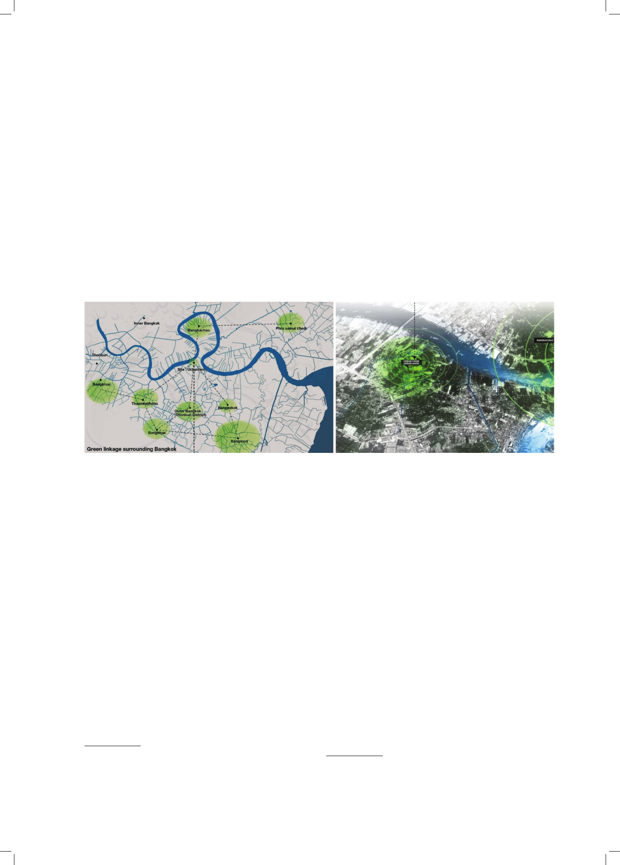
“Urban Farm Urban Barn” design for Bangkok (Thai-
land) with its 20 million inhabitants is connected with cre-
ating integrated nets of farmlands in the territory of the
existing city, which are supposed to provide the inhabitants
Zrównoważone strategie rewitalizacji zdegradowanych
terenów miejskich uwzględniają możliwości wprowadzania
farm produkcyjnych. Realizacje tych projektów są w fazie
eks perymentów: testowania technologii produkcji pod ką -
tem ekonomicznej opłacalności i wpływu na środowisko.
Przywrócenie więzi miasta ze wsią w formie tzw. wio-
sek miejskich stanowi istotne założenie rewitalizacji te -
renów zdegradowanych, poprzemysłowych oraz slumsów
i faveli w megamiastach, odwołujące się do poczucia
wię zi mieszkańców ze społeczeństwem agrarnym.
Projekt „Urban Farm Urban Barn” dla liczącego 20 mln
mieszkańców Bangkoku (Tajlandia) zakłada stworzenie
na terenie istniejącego miasta zintegrowanej sieci terenów
uprawnych, które mają zapewnić większe możliwości za -
Il. 6. „Nature City”. Jedna z prób kontynuacji idei miasta-ogrodu w XXI w. – „amerykański sen o mieście” [8]
Fig. 6. “Nature City”. One of the attempts to continue the idea of garden city in the 21
st
century – “American City Dream” [8]
Il. 7. Artificial Biotic Corridors,
eko-miasteczko turystyczne,
Syrakuzy, Włochy, 2005.
Widok z lotu ptaka. Projekt:
AION, Aleksandra Jaeschke
i Andrea Di Stefano [21]
Fig. 7. Artificial Biotic Corridors,
eco-tourist town Syracuse, Italy,
in 2005. Aerial view. Project:
AION, Aleksandra Jaeschke
and Andrea Di Stefano [21]
Agropolis. Część I. Nowa Atlantyda /Agropolis. Part I. New Atlantis 75
with greater possibilities of fresh food supplies and the
more efficient distribution through sales centres located in
the immediate neighbourhood. A model design of a city
farm and a sales centre of village and city agricultural prod-
ucts was situated in the territory of a former textile factory.
On the plot which is 1.4 hectares in area, a production farm
which meets the needs of the eco-centre was situated. The
adapted structures fulfil the gastronomic, commercial and
production functions and constitute an element of the nets
which are planned for the whole metropolis of city farms.
Basically, a prototype net of city farms is to restore self-
sufficiency and balance between consumption and food
production in the metropolitan area [22]. Enterprises of
this type constitute a specific continuation of agrarian cul-
ture in the territory of cities and are strongly supported by
people who mostly come from village areas [22] (Fig. 8).
opatrzenia ludności w świeżą żywność oraz sprawniejszą
dystrybucję poprzez centra sprzedaży zlokalizowane
w bez pośrednim sąsiedztwie. Modelowy projekt farmy
miejskiej i centrum sprzedaży produktów rolnych wiejsko-
-
miejskich usytuowano na terenie dawnej fabryki włó-
kien niczej. Na działce o powierzchni 1,4 ha zlokalizo wa-
no gospodarstwo produkujące na potrzeby ekocentrum.
Ada ptowane obiekty pełnią funkcje gastronomicz ne, hand-
lowe
i produkcyjne, stanowiąc element sieci plano wanych
dla całej metropolii farm miejskich. Prototypowa sieć
farm miejskich ma w założeniu przywracać sa mo wy star-
czalność i równowagę między konsumpcją a pro dukcją
żywności na obszarze metropolitalnym [22]. Tego typu
przedsięwzięcia stanowią swoistą kontynuację kultury ag -
rarnej na terenie miast i mają duże poparcie ludności wy -
wodzącej się w dużej części z terenów wiejskich [22] (il. 8).
Il. 8. Bangkok – koncepcja lokalizacji farm miejskich na terenach poprzemysłowych. Projekt firmy Isavaret Tamonut, TTH Trading Co., Ltd z Tajlandii [22]
Fig. 8. Bangkok – a location concept of city farms in the post-industrial areas. Design by Isavaret Tamonut, TTH Trading Co., Ltd from Thailand [22]
Projekty przekształceń miast w celu równoważenia
relacji między środowiskiem naturalnym i zabudo wa nym
polegają w większości na koncepcjach wy pełniania
niezagospodarowanych i zdegradowanych terenów far-
mami miejskimi. Koncepcja miast o nazwie CPULs
17
,
dą żąca do zmiany ich wyglądu na zdecydowanie natura-
listyczny, zakłada tworzenie sieci farm produkcyjnych na
terenach istniejącej zieleni miejskiej oraz w miejscach
wolnych od zabudowy i zdegradowanych. Powstające na
tych terenach farmy są formalnie i programowo podobne
do ogrodów miejskich [23]. Architekci Bohn & Viljoen
zaproponowali tego typu innowacyjne roz wią zanie –
sieci farm połączonych ze sobą zielonymi korytarzami –
na terenach Hawany, Londynu i Middles brough (il. 9).
Charakterystycznym przykładem układu korytarzowe-
go farm miejskich jest projekt dla Toronto o nazwie „Feed
Toronto: Growing the Hydrofields”
18
. Bazuje on na za ło-
17
CPULs – Continous Productive Urban Landscape (Ciągłe Pro-
duk cyjne Krajobrazy Miejskie) [23].
18
Projekt konkursowy „Feed Toronto: Growing the Hydrofields”
wykonany w 2010 r. przez zespół: Drew Adams, Fadi Masoud, Karen
May, Denise Pinto and Jameson Skaife [24].
Designs of transforming cities in order to balance the
relations between the natural and the developed environ-
ment consist mainly in concepts of fulfilling undeveloped
and degraded areas with city farms. The concept of cities
called CPULs
17
, which seeks to change their appearance
to a naturalistic one, assumes establishing production
farm nets in the territories of the existing city green areas
and in the places free of developments and in degraded
areas. Farms, which are set up in these areas, are formally
similar to city gardens and they follow their programme
[23]. Architects Bohn & Viljoen proposed an innovative
solution of this type – nets of farms connected with one
another by means of green corridors – in the areas of
Havana, London and Middlesbrough (Fig. 9).
“Feed Toronto: Growing the Hydrofields”
18
design for
Toronto is a characteristic example of a corridor system of
city farms. It is based on the assumption that the city
farming should be realised first of all in the public green
17
CPULs – Continuous Productive Urban Landscape [23].
18
Competition design “Feed Toronto: Growing the Hydrofields”
was produced in 2010 by Drew Adams, Fadi Masoud, Karen May,
Denise Pinto and Jameson Skaife [24].
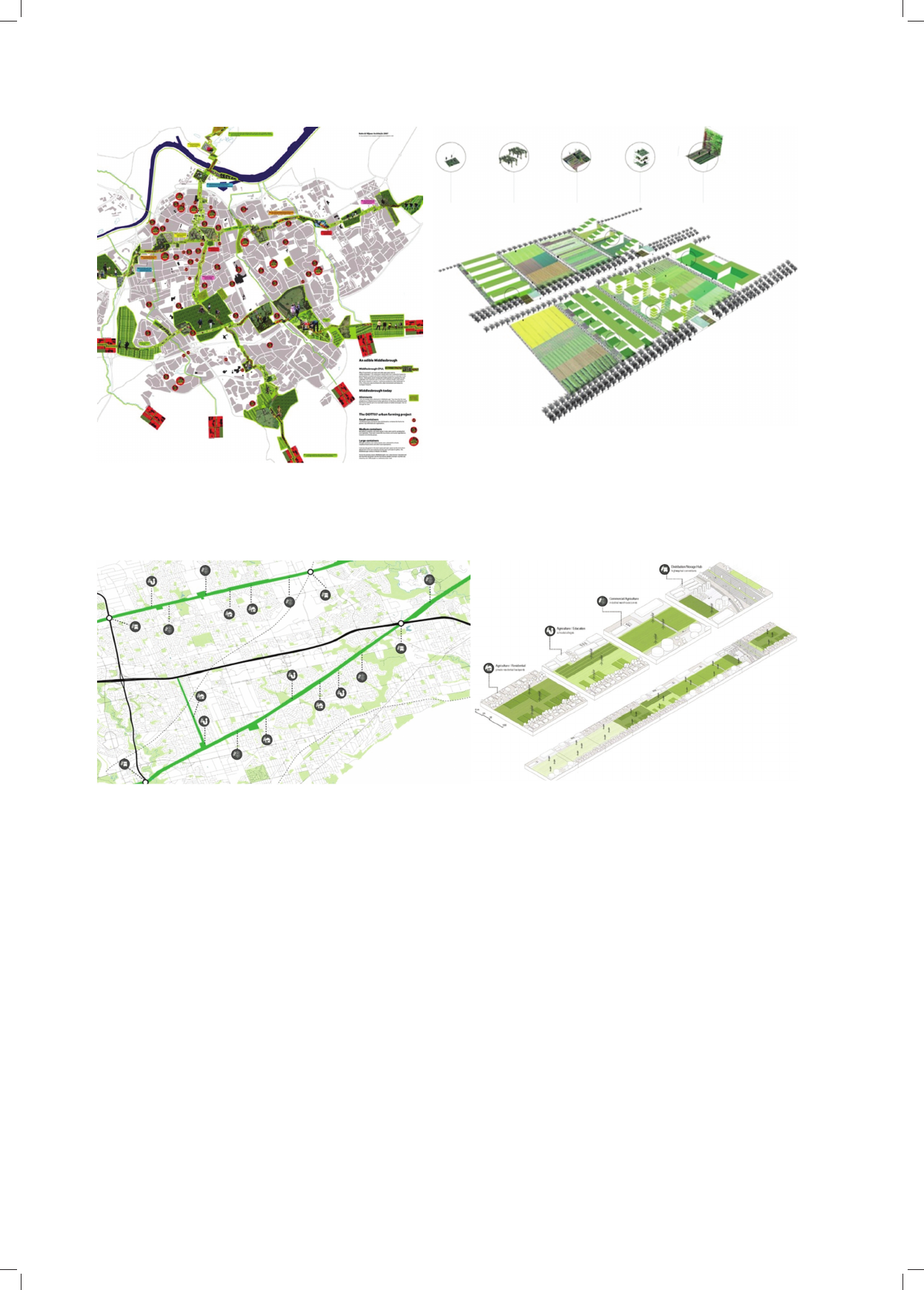
76 Bogusław Wowrzeczka
areas in the form of “corridors of agricultural produc-
tion”. A corridor system has an open character with a pos-
sibility to add new elements and then expand them. It is
a flexible solution which allows the adaptation to chang-
ing needs of inhabitants (Fig. 10).
In an area of 3200 hectares there are plans to build
“hydro corridors” which are differentiated in terms of
types of crops and which adapt to the needs of the deve-
lopment situated along the corridors. In this design typo-
logy of farms is subordinate to functional zones through
which corridors run: residential areas farms, farms in
school and university areas, farms in industrial and ware-
house areas as well as crossings with the transport infra-
structure [24].
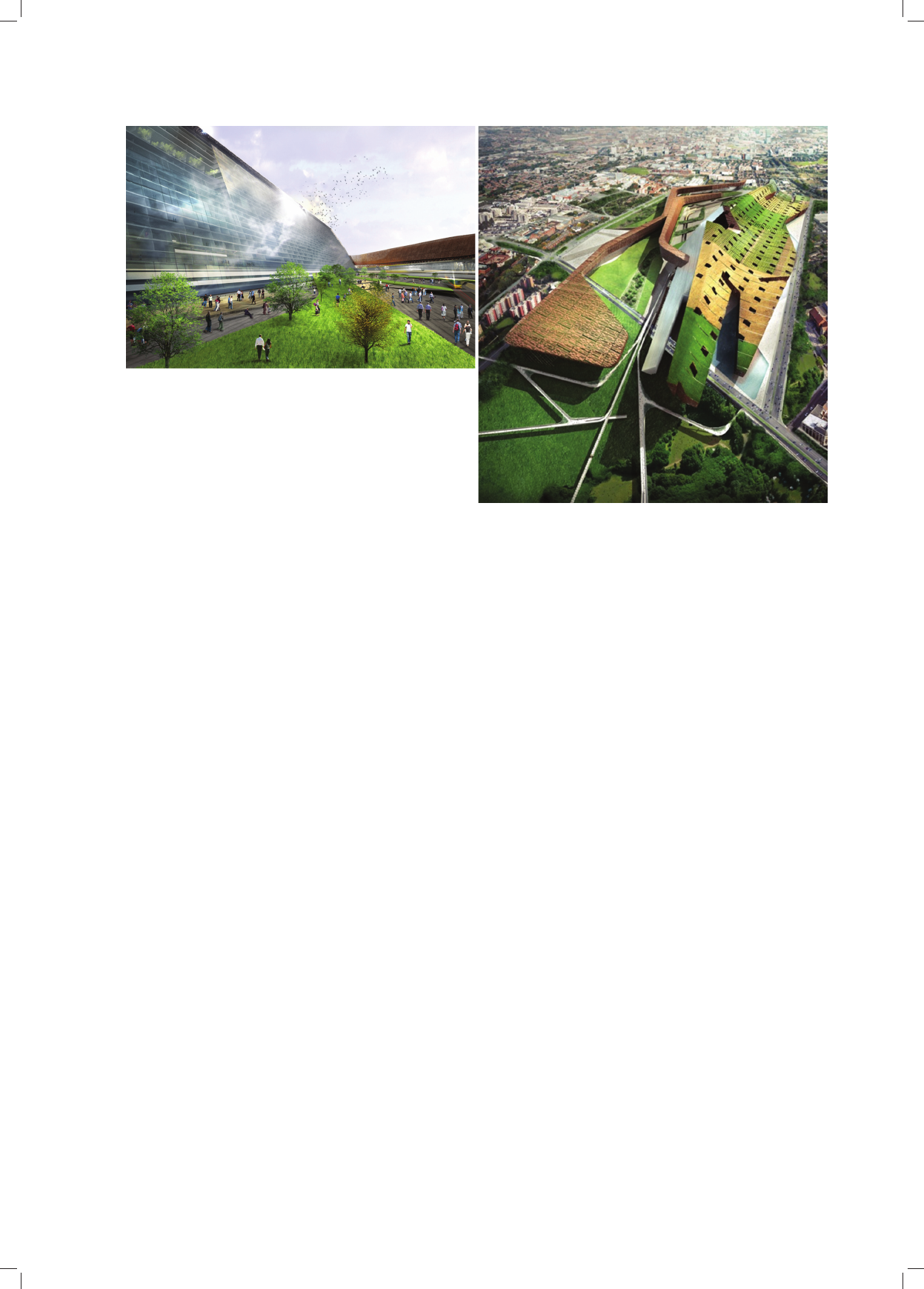
A radical design of redeveloping the historical centre
peripheries of Milano proposes a self-sufficient city com-
żeniu, że miejskie rolnictwo powinno być reali zo wane
przede wszystkim na terenach zieleni publicznej w formie
„korytarzy produkcji rolniczej”. Układ korytarzowy ma
charakter otwarty z możliwością dodawania nowych ele-
mentów i ich powiększania. Jest to rozwiązanie elastycz-
ne pozwalające na dostosowanie się do zmie nia jących
potrzeb mieszkańców (il. 10).
Na powierzchni 3200 ha przewidziano „korytarze
wod ne” zróżnicowane pod względem rodzaju upraw
i do stosowujące się do potrzeb biegnącej wzdłuż zabu-
dowy. Typologia farm jest w tym projekcie podporząd-
kowana strefom funkcjonalnym, przez które przecho -
dzą koryta rze: farmy terenów mieszkaniowych, terenów
szkół i uczel ni, farmy w strefach przemysłowych, ma -
gazyno wych, i skrzyżowań z infrastrukturą trans porto-
wą [24].
Il. 9. Middlesbrough – koncepcja wprowadzenia farm miejskich na tereny wolne od zabudowy oraz tereny poprzemysłowe [23]
Fig. 9. Middlesbrough – a concept of introducing city farms into the areas free of developments and also into post-industrial terrains [23]
Il. 10. Projekt „Feed Toronto” – korytarze farm w strukturze miasta i przykładowe typy horyzontalnych farm miejskich:
farma zintegrowana z zabudową mieszkalną, ze szkołą, z supermarketem i z terenem przemysłowym [24]
Fig. 10. “Feed Toronto” Design – corridors of farms in the city structure and exemplary types of horizontal city farms:
a farm integrated with a residential development, school, supermarket and industrial area [24]
Agropolis. Część I. Nowa Atlantyda /Agropolis. Part I. New Atlantis 77
plex with city farms which constitute the basic source of
agricultural products [14]. On the one hand, the structure,
which is situated in the peripheries of the historical cen-
tre, is to be a self-sufficient residential and production
unit, while on the other hand, it is to be integrated spa-
tially with the tissue of the existing centre and in accor-
dance with the programme by offering mainly green areas
of recreation and crops. In this way, it supplements the
missing park areas in the centre (Fig. 11).
Agricultural areas were situated on the slope elevated
over the existing terrain and curved to the south. At the
foot of the slope a residential and service development for
25 000 people was located. The patchwork of plants is
based on the principle of using ideal places for each spe-
cies in relation to the sun exposition conditions and water
retention. The plants, which vegetate well in dry soil con-
ditions, grow on a higher place of the curved surface of
the area, whereas the plants which need moister soil grow
in the lower area [24]. The mega-structure design should
be considered difficult in terms of its realisation and the
one which requires considerable financial expenditures.
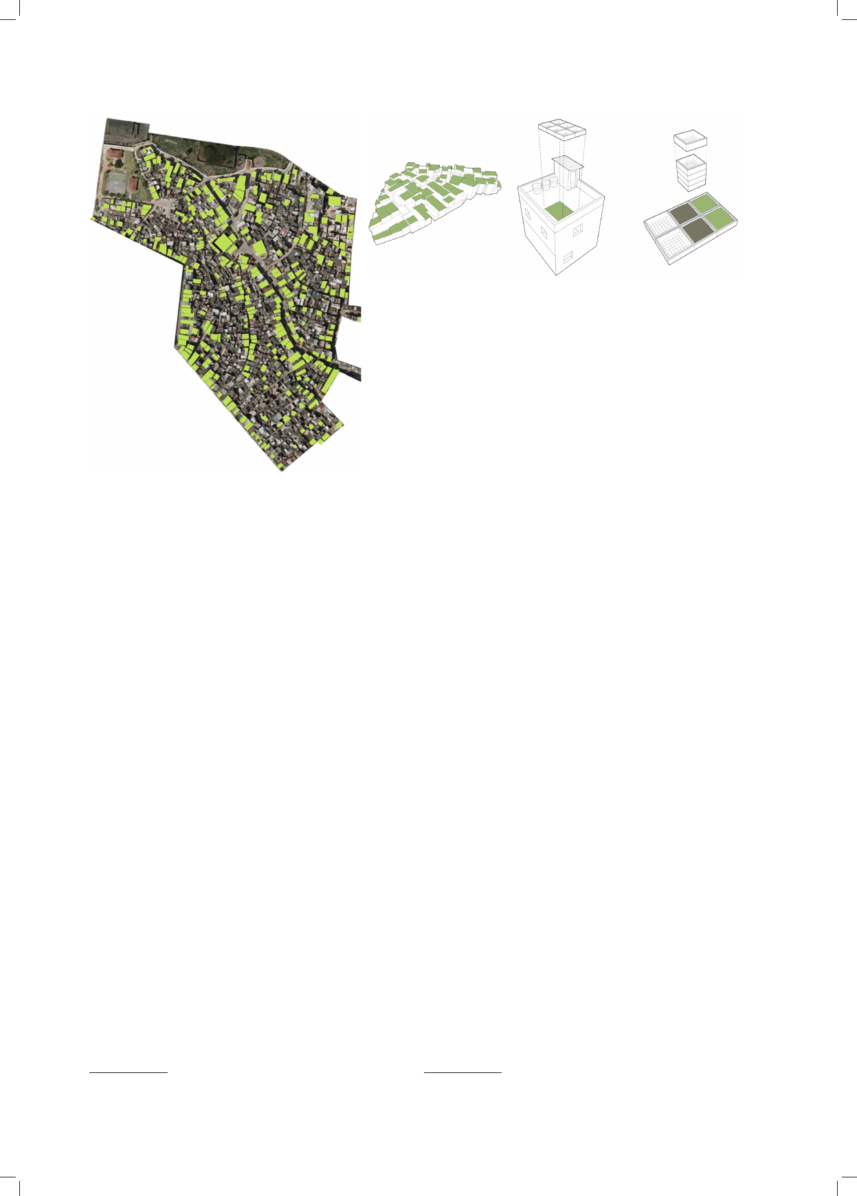
Transformation designs of favelas development focus
on propositions of taking advantage of roofs for cultivat-
ing crops, i.e. the areas of favelas are situated on steep
slopes, which provides the possibility to use a terrace
form of cultivation.
The design “Favela Farm” in Rio de Janeiro (Brazil)
by Oliver Leech assumes creating terrace production gar-
dens on slopes and roofs of buildings [25]. The obtained
products would be supplied to the inhabitants of favelas
and also for sale. Due to low initial costs, this concept
stands a chance of success and it may constitute a signifi-
cant supplementation of supplying favelas with agricul-
tural products (Fig. 12) [25].
A rapid growth of population in the Nile Delta, in
particular around Cairo and Alexandria (Egypt), forces
Radykalny projekt rewitalizacji obrzeża historycznego
centrum Mediolanu przewiduje stworzenie samowystar-
czalnego zespołu miejskiego z farmami miejskimi stano-
wiącymi podstawowe źródło zaopatrzenia w produkty
rol nicze [14]. Struktura usytuowana na obrzeżach hi sto-
rycz nego centrum ma stanowić z jednej strony samo wy-
starczalną jednostkę mieszkalno-produkcyjną, z drugiej
zaś integrować się programowo i przestrzennie z tkan ką
istniejącego centrum, oferując głównie zielone te reny rek-
reacji i upraw. Tym samym uzupełnia brakujące w cen-
trum tereny parkowe (il. 11).
Tereny rolnicze zostały umiejscowione na podniesio-
nym ponad teren istniejący i wygiętym w kierunku po -
łudnio wym stoku. Pod stokiem usytuowano zabudowę
mieszkalno-usługową dla 25 000 osób. Patchwork hodo-
wanych roślin jest oparty na zasadzie wykorzystywania
idealnych miejsc dla każdego gatunku, w odniesieniu do
wa runków ekspozycji słonecznej oraz retencji wody. Roś
-
liny, które dobrze wegetują w suchych warunkach gle -
bowych, są położone wyżej na wygiętej powierzchni
te
renu, podczas gdy te, które potrzebują bardziej wil got-
ne go podłoża, znajdują się w dolnym obszarze [14]. Pro-
jekt megastruktury należy uznać za trudny do realizacji
i wy magający sporych nakładów finansowych.
Projekty przekształceń zabudowy faveli koncentrują się
na propozycjach zagospodarowania dachów pod uprawy:
tereny faveli są zlokalizowane na stromych zbo czach, co
daje możliwość korzystania z formy tarasowej upraw.
Projekt Olivera Leecha „Favela Farm” w Rio de Janerio
(Brazylia) zakłada tworzenie tarasowych ogrodów pro-
duk cyjnych na zboczach oraz dachach budynków [25].
Otrzy mywane z nich surowce przeznaczone byłyby dla
mie szkańców faveli oraz na sprzedaż. Koncepcja ze wzglę-
du na niskie koszty początkowe ma szanse reali zacji
i może stanowić istotne uzupełnienie zaopatrzenia faveli
w produkty rolne (il. 12) [25].
Il. 11. Projekt Milano Stadt Krone 2030 (Studio Shift):
warstwa uprawna i ogrody od strony południowej [14]
Fig. 11. Milano Stadt Krone 2030 Design (Studio Shift):
topsoil and gardens in the south [14]
78 Bogusław Wowrzeczka
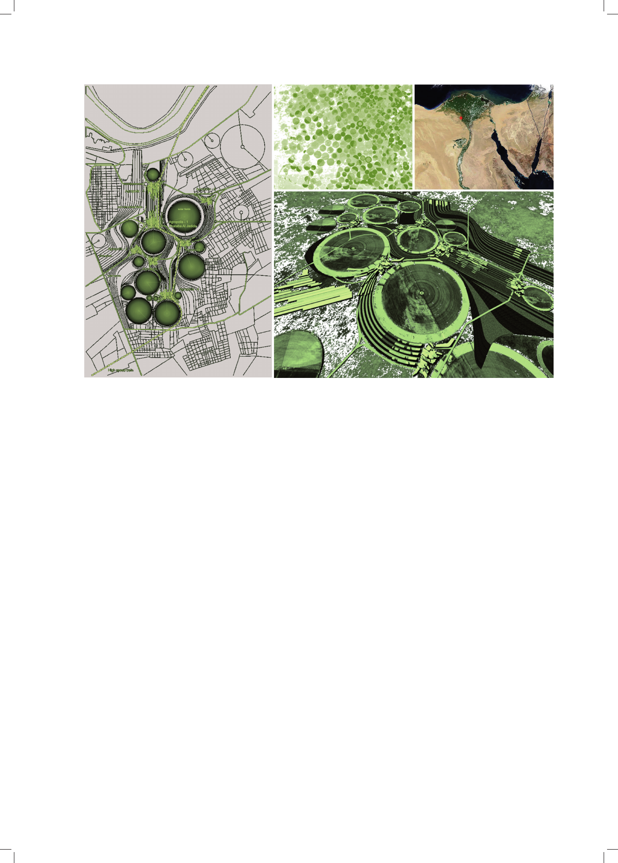
Szybki wzrost liczby ludności w delcie Nilu, zwłaszcza
wokół Kairu i Aleksandrii (Egipt), zmusza setki tysięcy
ludzi do zamieszkiwania na pustyni w zamkniętych kon-
dominiach dla bogatych albo w powstających w sposób
nie kontrolowany slumsach. Khataba (Al Jadida) jest pro-
pozycją stworzenia sieci osiedli na obszarze delty Nilu –
samowystarczalnych pod względem produkcji żywności
i energii. Koncepcja zakłada linearno-kołową ich struk-
turę morfologiczną
19
. Liniowo rozciągające się przestrze-
nie zabudowane łączą powierzchnie upraw oparte na op -
tymalnym w tym klimacie wzorcu uprawy tworzonej na
rzu cie koła. Zabudowa o zróżnicowanej in ten sywności
i standardzie wykorzystuje tereny pomiędzy okręgami,
które obecnie nie są użytkowane. Zakłada się recykling
odpadów i wykorzystanie energii słonecznej do zaspoko-
jenia potrzeb energetycznych osiedla (il. 13) [26].
Porównanie rozwiązań przestrzennych farm miejskich
na terenach rewitalizowanych pozwala na stwierdzenie,
że typologia układów zagospodarowania przestrzennego
pokrywa się w wielu przypadkach z typologią form mia-
sta, może jednak też stanowić odrębną formę. Najczęściej
w koncepcjach miast nowych występują rozwiązania cen-
tralne i linearne, w miastach istniejących zaś są to formy
korytarzowe, formy wyspowe oraz punktowe: wertykalne
lub horyzontalne, w układzie sieciowym lub nieregular-
nie rozproszonym na dużym obszarze.
Koncepcje agromiast i przekształceń istniejących
struktur miejskich w agromiasta powstały na gruncie teo-
rii miasta zrównoważonego i stanowią nową jakość
w roz woju urbanistyki. Traktowanie miasta jako samo-
wy starczalnego organizmu produkującego żywność dla
19
Konkurs na miasto samowystarczalne, Kair, Egipt. Zespół pro-
jektowy: marcosandmarjan [26].
hundreds of thousands of people to live in the desert in
closed condominiums for the rich or in slums which are
built in an uncontrolled way. Khataba (Al Jadida) is
a proposition of building residential housing nets in the
area of the Nile Delta – self-sufficient in terms of food
and energy production. According to the concept, its mor-
phological stru cture is to be linear and circular
19
. The
developed areas, which spread linearly, connect the areas
of crops that are based on an optimal in this climate model
of culti vation on the projection of a circle. The develop-
ment of a di verse intensity and standard takes advantage
of the areas between circles which are not used at the
moment. The con cept also assumes waste recycling and
solar energy use to meet energy needs of the housing
estate (Fig. 13) [26].
A comparison of spatial solutions of city farms in the
revitalised areas leads to the conclusion that the typology
of land development systems in many cases coincides
with the typology of city forms, however, it may also con-
stitute a separate form. Most often in the concepts of new
cities there are central and linear solutions, whereas in the
already existing cities corridor, island and point forms can
be observed, i.e. vertical or horizontal in the net system or
irregularly scattered within a large area.
The concepts of agro-cities and transformations of the
existing city structures into agro-cities were developed on
the basis of a sustainable city theory and constitute a new
quality in the development of urban planning. Treating
a city as a self-sufficient organism which produces food
for its inhabitants is an evolutionary continuation of
Howard’s idea of garden cities based on new principles of
19
Self-sufficient city competition, Cairo, Egypt. Design team:
marcosandmarjan [26].
Il. 12. Favela w Rio de Janeiro – koncepcja farm na dachach budynków;
uprawy warzyw i owoców w pojemnikach z recyklingu [25]
Fig. 12. Favela in Rio de Janeiro – a concept of farms on roofs of buildings;
growing fruit and vegetables in recycled containers [25]
Agropolis. Część I. Nowa Atlantyda /Agropolis. Part I. New Atlantis 79
sustainable spatial and economic development. New
designs of self-sufficient cities on the water with algae
farms by Vinncent Callebaut [27] constitute one of the
possible options of this evolution in the future, which in
this way realise a utopia of New Atlantis where:
In orchards and gardens we know how to [...] artifi-
cially cause flowers and fruits to grow earlier or later
than normally, while plants germinate, start to produce
buds and bear fruit faster than it follows from their nature.
We can make trees and other plants bigger than normal
and their fruits more splendid, more pleasant and varied
as regards taste, smell, colour and shape than an ordinary
species [...]. Using methods known to us, we make numer-
ous plants sprout and grow without a seed. We are also
able to develop plants that are completely new and
unknown, different from the common ones and transform
one plant species into another one [28].
Translated by
Bogusław Setkowicz
swoich mieszkańców jest ewolucyjną kontynuacją Ho -
wardowskiej idei miast-ogrodów, opartą na nowych zasa-
dach zrównoważonego rozwoju przestrzennego i gospo-
darczego. Powstające projekty samowystarczalnych miast
na wodzie z farmami alg morskich Vinncenta Callebauta
[27] stanowią jedną z możliwych opcji tej ewolucji
w przy szłości, urzeczywistniając tym samym utopię
Nowej Atlantydy, na której:
Umiemy w […] sadach i ogrodach sztucznie sprawiać,
iż kwiaty i owoce rozwijają się wcześniej lub później niż
w czasie właściwym, a rośliny kiełkują, puszczają pączki
i owocują prędzej, niż wynika to z ich natury. Możemy
uczynić, by drzewa i inne rośliny były większe niźli nor-
malnie, a owoc ich okazalszy, przyjemniejszy i odmienny
pod względem smaku, zapachu, barwy i kształtu od ga -
tunku zwyczajnego […]. Znanymi nam metodami dokonu-
jemy, iż liczne rośliny wschodzą i wyrastają bez nasienia.
Jesteśmy również w stanie wyhodować rośliny zgoła
no we i nieznane, róż
niące się od pospolitych, oraz prze-
mie niać jeden gatunek rośliny w inny [28].
Il. 13. Khataba Agropolis (Egipt) – koncepcja samowystarczalnego zespołu w delcie Nilu [26]
Fig. 13. Khataba Agropolis (Egipt) – a concept of a self-sufficient unit in the Nile Delta [26]
Bibliografia /References
[1] Waldheim Ch., Notes Toward a History of Agrarian Urbanism.
Design Observer Winterhouse, http://places.designobserver.com/
feature/notes-toward-a-history-of-agrarian-urbanism/15518/
[accessed: March 2013].
[2] Gutowski B., Przestrzeń marzycieli. Miasto jako projekt utopijny,
Warszawa 2006, http://www.miastoidealne.sztuka.edu.pl/filozofia_
miasta_miasto_jako_projekt_utopijny.pdf [accessed: May 2013].
[3] Register R., Ecocity Berkeley: Building Cities for a Healthy
Future, North Atlantic Books, Berkeley 1987.
[4] Hall P., Megacities, World Cities and Global Cities, The First
Megacities Lecture, Rotterdam 1997, http://www.megacities.nl/
lecture_1/lecture.html [accessed: March 2013].
[5]
Kostof S., The City Shaped: Urban Patterns and Meanings Through-
out History, Little, Brown and Company, Boston 1991, 38–39.

80 Bogusław Wowrzeczka
[6] Miasto-ogród, http://pl.wikipedia.org/wiki/Miasto-ogród;
[accessed: February 2013].
[7] Bruno Taut, http://en.wikipedia.org/wiki/Bruno_Taut; [accessed:
April 2013].
[8] Barliant C., Collinge A., Urban Farmers, „ICON” 2012, No. 104,
64–69.
[9] Bullivant L., Masterplanning Futures, Routledge, New York 2012.
[10] Budniak M., EXPO 2010. Zielone miasto – lepsze miasto, „Green²”
2010, nr 4, 18–21.
[11] Palej A., Farmy miejskie – przedsięwzięcia wspomagające stra-
tegie zrównoważonego rozwoju miast, „Czasopismo Techniczne”
2010, z. 14, „Architektura” z. 6-A2, 40–44.
[12] Koering D., Floating Permaculture, „I’ARCA” 2012, No. 276,
52–55.
[13]
Carrot City, http://www.ryerson.ca/carrotcity/ [accessed: May 2013].
[14] Milano Stadt Krone 2030 Farm Gap 2010 R. Forum (AUFO)
Milano, Comune di Milano. Studio Schift: Mario Cipresso,
Andrew Kim, Alex Fishman, Dana Mangahis, Marisol Mejia,
Stephen Morton, http://www.studioshift.com/index.php?/master-
plan/milano-stadt-krone-2030/ [accessed: March 2013].
[15] Gorgolewski M., Komisar J., Nasr J., Carrot City: Designing for
Urban Agriculture, Monacelli Press, Crown Publishing Group,
New York 2011.
[16] Fehrenbacher J., MVRDV’s PIG CITY, „INHABITAT”, 06/15/06,
http://inhabitat.com/mvrdvs-pig-city/ [accessed: February 2013].
[17] Work Architecture Company: Plug Out, http://work.ac/plug-out/
[accessed: January 2013].
[18] Vinnitskaya I., D.I.Y Urbanism: Almere Oosterworld/MVRDV,
„ArchDaily”, 22 April 2012, http://www.archdaily.com/227503
[accessed: May 2013].
[19] Autonomous City, First Prize, Arizona Challenge, Drew Adams,
Fadi Masoud and Daniel Ibañez, http://www.adams-masoud.com/
index.php?/projects/autonomous-city/ [accessed: April 2013].
[20] Jaeschke A., Stratyfikacja pól i sieci. Aion: Campus Urbisi
Artificial Biotic Corridors, „Green²” 2010, nr 3, 17–31.
[21] Artificial Biotic Corridors co-resort, Research project Siracusa,
Italy, 2004–2005, research team: Andrea Di Stefano, Aleksandra
Jaeschke, http://www.a-i-o-n.com/index.php?p=020 [accessed:
April 2013].
[22] Urban agriculture and factory conversion, Bangkok, Thailand,
http://www.holcimfoundation.org/T1400/A11APsiTH.htm
[accessed: April 2014].
[23] CPULs – Continous Productive Urban Landscape, http://www.
ryerson.ca/carrotcity/board_pages/city/CPULs.html [accessed:
February 2013].
[24] Adams D., Masoud F., May K., Pinto D., Skaife J., Feed Toronto:
Growing The Hydrofields, http://www.adams-masoud.com/index.
php?/projects/feed-toronto-growing-the-hydro-fields/ [accessed:
March 2013].
[25] Leech O., Favela Farm, http://unitsixteen.com/2013/02/09/favela-
farm-oliver-leech/ [accessed: April 2013].
[26] NeoArch Neoplasmatic Architecture – the blog of Marcos Cruz,
http://marcoscruzarchitect.blogspot.com/2009/01/khataba-al-jadi-
da-agropolis.html [accessed: March 2013].
[27] Callebaut V., Algae Farm and Bio-Hydrogene Airship, http://vin-
cent.callebaut.org/page1-img-hydrogenase.html [accessed: May
2013].
[28] Bacon F., Nowa Atlantyda, tłum. W. Kornatowski, http://sady.up.
krakow.pl/antfil.bacon.nowaatlantyda.htm [accessed: March 2013].
Streszczenie
Współczesne strategie tworzenia zrównoważonych ekosystemów miejskich stały się podstawą dla nowych koncepcji miasta, w których zaciera się
różnica między funkcjami dotychczas będącymi domeną terenów wiejskich i miejskich – miasto staję się miejscem produkcji rolniczej. Taka forma
przekształceń struktury funkcjonalno-przestrzennej miasta stanowi nową koncepcję kontynuacji idei integracji środowiska naturalnego z miastem
– XIX-wiecznej utopii miasta-ogrodu Ebenezera Howarda, której pierwowzorem była Nowa Atlantyda Francisa Bacona (XVII w.).
Słowa kluczowe: utopia, miasto-ogród, farma miejska, tereny poprzemysłowe, rewitalizacja
Abstract
Contemporary strategies for creating sustainable urban ecosystems have become the basis for a new concept of the city in which the distinction
between the functions blurs although they once were the domain of rural and urban areas, and the city becomes a place of agricultural production.
This form of transformation of the urban structure represents a new continuation idea of integration of the environment and the city – 19-century
utopian Garden City Ebenezer Howard, whose prototype was Francis Bacon’s New Atlantis.
Key words: utopia, a city garden, urban farm, post-industrial areas, revitalization