2020
2(62)
DOI: 10.37190/arc200210
Introduction
The importance, history, and past investigations of the
UNESCO World Heritage Site of El Fuerte de Samaipata
have already been studied by numerous scholars [1]–[9].
A more comprehensive current study of former research is
included in the same issue of this journal
1
. Here, we will
concentrate on describing particular sectors of the rock in
light of the results of our multidisciplinary documentation
project carried out in the years 2016–2019.
* ORCID: 0000-0003-0623-8071. Faculty of Architecture,
Wrocław University of Science and Technology, e-mail: jacek.kosciuk@
pwr.edu.pl
** Italian Centre for Pre-Columbian Archaeological Studies
and Research in Nazca (Peru).
*** ORCID: 0000-0003-4137-0799. Centre of Andean Studies
of the University of Warsaw in Cusco (Peru).
**** ORCID: 0000-0001-5442-3947. Faculty of Architecture,
Wrocław University of Science and Technology.
***** Italian Centre for Pre-Columbian Archaeological Studies
and Research in Nazca (Peru).
1
Cf. M. Ziółkowski, El Fuerte de Samaipata in the light of current
research, in the same issue of “Architectus”.
Jacek Kościuk*, Giuseppe Orefici**, Mariusz Ziółkowski***,
Anna Kubicka****, Rosario Muñóz Risolazo*****
Description and analysis of El Fuerte de Samaipata
in the light of new research,
and a proposal of the relative chronology
of its main elements
Opis i analiza El Fuerte de Samaipata
w świetle nowych badań
oraz propozycja względnej chronologii
jego głównych elementów
Applied techniques and methods
During this project, we used several methods to doc-
ument the site – 3D terrestrial laser scanning (TLS)
2
and
multisensory close-range digital photogrammetry
3
for the
whole site, as well as structured light scanning for the
most important petroglyphs
4
. The data from TLS and
digital photogrammetry were collected during the eld-
work season in June and July 2016, and from structured
light scanning in July 2017. All data were compiled in
the Laboratory of 3D Scanning and Modeling at the De-
partment of History of Architecture, Arts and Technol-
ogy at Wrocław University of Science and Technology.
2
Cf. J. Kościuk, B. Ćmielewski, M. Telesińska, A. Kubicka, 3D
terre strial laser scanning of El Fuerte de Samaipata, in the same issue
of “Architectus”.
3
Cf. B. Ćmielewski, I. Wilczyńska, C. Patrzałek, J. Kościuk, Digi-
tal close-range photogrammetry of El Fuerte de Samaipata, in the same
issue of “Architectus”.
4
Cf. J. Kościuk, M. Telesińska, M. Nisztuk, M. Pakowska, Docu-
mentation of the most important petroglyphs by structured light scanning
and analysis of the most damaged petroglyphs by vPTM and vRTI meth-
ods, in the same issue of “Architectus”.
80 Jacek Kościuk, Giuseppe Orefici, Mariusz Ziółkowski, Anna Kubicka, Rosario Muñóz Risolazo
The results of the data compilation were raster orthoim-
ages (monochromatic and in RGB) with a resolution of
1 mm for photogrammetry and 10 mm for TLS. For both,
dierent hill-shading algorithms were used to emphasise
characteristic features of the rock surface. This proved
extremely important in the next stage of work, when or-
thoimages were used to prepare vector plans for the entire
rock, including all its terraces, niches, reservoirs, canals,
and petroglyphs. Replacing raster references during on-
screen vectorisation facilitated the interpretation of details
invisible on colour imagery or, on the contrary, provided
additional information for the grayscale terrain model.
Vector maps obtained courtesy of Albert Meyers, the head
of the German research project at Samaipata carried out
by the University of Bonn from 1992 to 1997, were also
very helpful when interpreting the most eroded parts of
the rock [9, p. 28, Fig. 9]. At this stage of our project, we
also consulted all previous topographical plans. The vec-
tor plan resulting from this back-oce work was brought
to the site during the 2017 eldwork season to check for
possible omissions or misinterpretations. The nal plan,
together with raster references, is now available in open
geographic information system (GIS)
5
format
6
.
Since the part of Samaipata rock that has been surveyed
in detail measures roughly 110 × 240 m, it is technically
impossible to present it on one illustration in this paper.
5
Unless otherwise stated, all illustrations are by J. Kościuk. The
le gend for the graphics on the plans can be found on page 78.
6
I. Wilczyńska, P.B. Dąbek, B. Ćmielewski, J. Kościuk, Integra-
tion of project results on a GIS platform and its impact on conservation
strategies, in the same issue of “Architectus”.
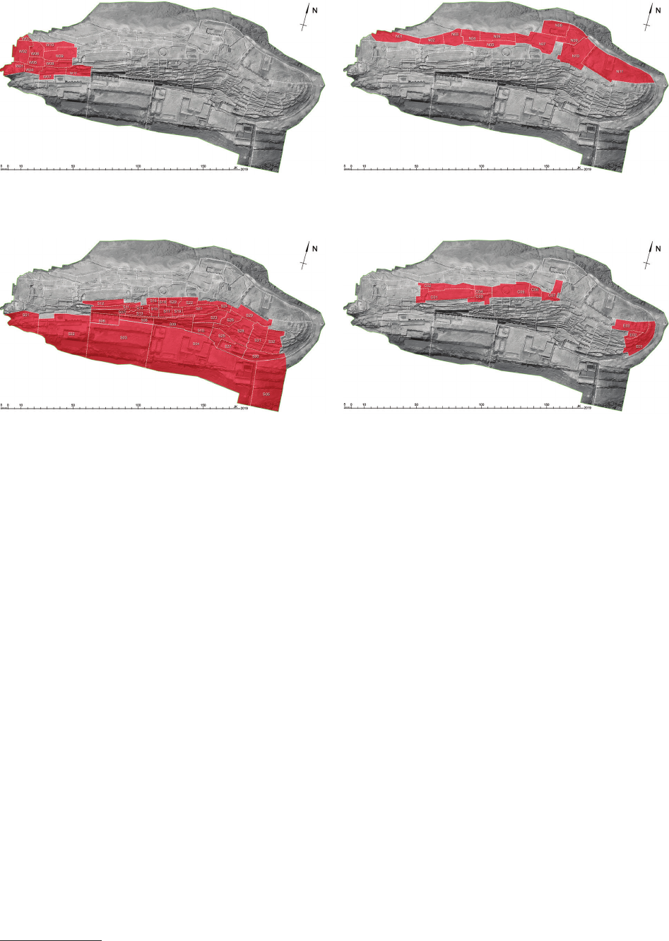
Therefore, the site has been divided into ve areas. Each
area, according to principal morphological, and to some
degree, functional, features, was then split into several fur-
ther sectors. Each sector name starts with the letter den-
ing its rough location – “W” for the western part (Fig. 1),
“N” for the northern part (Fig. 2), “S” for the southern part
(Fig. 3), and “C” for the central and “E” for the eastern
parts (Fig. 4). Sector names are then completed with num-
bers. These numbers begin at “01” for each of the ve are-
as of the site and follow on sequentially from this.
Results and discussion
The description of the results will follow the naming
convention described above. It will start with the western
part of the site; then it will cover the northern and southern
slopes of the rock, continue with the central sectors, and
terminate with the easternmost end of the rock.
Western part of the rock
Sector W01
This sector lies in the westernmost part of the rock,
just below and behind the modern viewing platform
erected for visitors (Fig. 1). In this sector, earth has ac-
cumulated and covers the natural rock. Three circular
structures and an L-shaped fragment of a wall, all con-
temporary reconstructions made of stone and clay, are
extant there. Since the main aim of the project was to
document and analyse original, Incan or pre-Inca carv-
ings on the rock, this sector is out of the scope of this
paper and is mentioned only for the sake of completeness.
Fig. 1. The western group of sectors of the rock
5
Fig. 3. The southern group of sectors of the rock
Fig. 2. The northern group of sectors of the rock
Fig. 4. The central and eastern groups of sectors of the rock
ElFuertedeSamaipatainthelightofnewresearch / ElFuertedeSamaipatawświetlenowychbadań 81
Sector W02
Sector W02 lies directly northward from sector W01, and
it gently slopes downwards to the east (Fig. 5). The eastern
limit of sector W02 forms a well-dened edge with trac-
es of two triangular recesses in its southern part. Close to
the western border of the sector, two raised terraces can be
seen. The area further to the west is currently unexcavated,
and earth, as well as small bushes, are possibly covering the
next sequence of terraces. The slope of this sector provides
perfect conditions for spectators watching events and cel-
ebrations in the central part of the rock located to the east.
A line of circular holes (ca. 16 cm in diameter) drilled
into the rock marks the northern extent of sector W02.
These are easily distinguishable from natural cavities in
the sandstone, which are typically ellipsoid in shape. The
circular holes are irregularly spaced with distances from
ranging from 0.4 m to 1.2 m. According to our interpreta-
tion, they were used to place the wooden posts of a quin-
cha wall that was once standing there
7
.
Sector W03
This triangular sector lies to the north of the quincha
wall line (Fig. 5). The remaining borders are the natu-
ral(?), very eroded edge of the rock (north-eastern border)
7
Cf. J. Kogut, J. Kościuk, A. Kubicka, Interpretation of traces of
hypothetical quincha walls in Samaipata, in the same issue of “Archi-
tectus”.
Fig. 5. Sectors W01–W06
82 Jacek Kościuk, Giuseppe Orefici, Mariusz Ziółkowski, Anna Kubicka, Rosario Muñóz Risolazo
and the north-western extent of the excavated area where
the rock is still visible. The only anthropogenic feature
in this sector is a small natural cavity in the rock that
might have been used as an oering (libation) hole, as it
has traces of an intensely eroded channel running to it.
Sector W04
Sector W04 lies directly to the east of sector W01,
and it slopes downwards to the south (Fig. 5). The south-
western part is covered with accumulated earth, while the
face of the natural rock is exposed on the remaining part
of the sector. A line of natural cracks in the rock marks
the northern limit of the sector. A similar crack, this time
north–south orientated, divides the sector into two parts.
Aside from traces of what might once have been a small
rectangular shelf, there are no other identiable signs of
intentional shaping of the rock in the western part of the
sector. Many more traces, although extremely eroded, are
found in the eastern section. In the northern area of the
eastern section, a shallow terrace ca. 1.2 m wide cuts into
the slope of the rock. Its upper edge marks the northern
extent of this part of the sector. Another east–west orien-
tated terrace, this time only ca. 0.75 m wide, is located
further towards the south.
In the northern part, the eastern boundary of the sec-
tor corresponds with a step leading down to a wide ter-
race located further to the east, while in the southern part,
a row of four round holes drilled into the surface of the
rock mark the edge of the sector. The arrangement of
these holes strongly resembles those found in the northern
part of sector W02. Thus, we interpret them as traces of
another quincha wall. We do not exclude the possibility
that this hypothetical quincha wall continued further in
a north-eastern direction, and climbed the narrow terrace
described above.
Sector W05
The main feature of this sector is a spacious (ca. 8.5
× 6.0 m), roughly horizontal platform with well-dened
edges on its northern and eastern side (Fig. 5). In the cen-
tral part of this platform, a circular shape (roughly 2.25 m
in diameter) rises ca. 10 cm above the platform level. In
the centre of this shape, very weather-beaten traces of
a gural petroglyph are extant. Earlier research described
it as a representation of a felid – possibly a puma or jag-
uar. Today, it is dicult to see the gure, let alone assign it
to a particular subspecies. However, with some help from
virtual polynomial texture mapping (vPTM) and virtual
reectance transformation imaging (vRTI) techniques,
it was possible to recognise a shape suggesting the rep-
resentation of a puma. Nevertheless, this interpretation
must be treated with great caution since the surface of the
petroglyph is highly eroded and additionally disturbed
by mosses and lichens. Further doubts are raised when
comparing our reconstruction with a drawing by Alcide
d’Orbigny en Ponce from 1832, where the schematic rep-
resentation of the puma(?) is turned 180 degrees (Fig. 6).
On the other hand, in the textual description of the draw-
ing clearly representing animalistic gures, d’Orbigny
writes Dentro de esta hipótesis, sería lícito creer también
que las medias lunas FF de la parte baja representarían
los primeros y los últimos cuartos de la luna, andando de
este a oeste [1, p. 1465] so perhaps the gure in question
is rotated in order to t his hypothesis.
The rough rock surface, especially around the north-
western edge of the circle, may suggest that the gure has
been intentionally recut (and perhaps also erased) by later
occupants of the site. This observation may point to the
pre-Inca origin of this petroglyph.
One can get a similar impression by analysing the very
shallow carvings of two T-shaped reservoirs(?) located
south of the petroglyph. They are visible only on the hill-
shaded 3D model without texture, as texture obscures
the weak traces of these shapes. These carved reservoirs
show further evidence of a second phase of rock shaping,
as the upper edge of the northern terrace of sector W04
cuts into the eastern reservoir. Thus, both carved reser-
voirs can be attributed to the pre-Inca phase of the shaping
of the rock.
The western edge of the central platform of W05 has
two steps. The rst one forms a roughly 50 cm-wide bench
elevated ca. 12–25 cm above the main platform level. It
continues along the northern edge of the sector and runs
until it reaches a narrow channel connecting this sector
with sector W06. The position of this channel corresponds
with a natural crack in the rock, and probably this connec-
tion between both the sectors is also of late provenance.
The second step on the western edge of the central
platform consists of two recesses cut into the slope. The
Fig. 6. Fragment of drawing by Alcide d’Orbigny en Ponce from 1832
(reproduced from [9, p. 25, Fig. 5])
ElFuertedeSamaipatainthelightofnewresearch / ElFuertedeSamaipatawświetlenowychbadań 83
northern one is smaller (60 × 80 cm) and forms a small
seat, while the southern one is much more spacious and
has a less regular shape. Further to the west lies a at area
that extends until another step about 25 cm in height.
Sector W06
This sector lies directly north of sector W05 and is very
similar (Fig. 5). Its central part is also a large (6.5 × 10.5 m),
roughly horizontal platform with a gural petroglyph em-
bedded into a circular shape raised above the platform
level. However, in this case, the circle is surrounded by
a ca. 35 cm-wide and 15–25 cm-deep channel that directs
water to the north.
The gural representation is relatively well preserved,
and the silhouette of a sneaking felid (possibly a jaguar)
is easy to recognise. The petroglyph gives some evidence
that it was altered in later periods. The channel surround-
ing it might be a later addition or at least have been recut.
Further to the north-west in sector W06 lies the area
where, according to the earlier investigators [5], a rep-
resentation of a coiled snake was once clear. Today, no
traces of it can be seen. Using vPTM and vRTI tech-
niques, we were able to identify at most a vague outline of
a snake crawling towards the north-west. We did not nd
any archival photographs that could indisputably conrm
that there was a depiction of a coiled snake. Instead, we
found the opposite – d’Orbigny in his drawing from 1834
(Fig. 6) clearly shows, although schematically, a snake
crawling towards the north-west. However, this random
possible coincidence does not prove the correctness of
our reconstruction. The preserved traces are so indeci-
pherable that they also allow for several other interpreta-
tions. Despite this, the one proposed here seems to be the
most reliable.
In this area of the sector, there are traces of another
small channel running to the east and joining the other
channel at a position where yet another channel joins from
the west. All three channels disperse water down the slope
in a north-western direction, across the line of a hypothet-
ical quincha wall.
The main platform of sector W06 is well dened from
the south and the west. Its southern border is a 6 m-wide
edge separating sectors W06 and W05. To the west, there
is a bench (roughly 50 cm wide) elevated ca. 12–25 cm
above the main platform level – similar to that in sector
W05. Two small (roughly 30 × 60 cm) symmetrical seats
have been cut into the upper edge of the back of the bench.
Further to the west lies a 3 m-wide at area that continues
until another step about 50 cm high.
In the middle of the western margin of the platform,
roughly adjacent to the gural petroglyph, a spacious
(ca. 2.5 × 2.5 m) recess with three nearly vertical sides at
least 70 cm high cuts into the slope. At present, the bottom
of this recess lies ca. 0.5 m below the level of the central
platform, but this might be due to local erosion of the rock
or later modications. The original bottom surface of the
recess is still visible on the western side in the northern
and southern corners. It is ca. 30–40 cm higher than the
level of the central platform. One can only speculate about
the original function of this recess. Perhaps it was a kind of
ceremonial seat associated with rituals celebrated around
the two petroglyphs in the central part of this sector.
The eastern margin of sector W06 is not as sharply de-
ned as the western one. Only a very shallow step, not
more than 20 cm high, separates it from neighbouring
sector W09. Since this step cuts into a at area where
there was once a representation of a rhea (ñandú), the
main platform of sector W06 must have been arranged
(or recut) in later periods, with the rhea representation
pre-dating it. The same applies to the central platform of
sector W05. Its north-eastern corner also cuts into the area
of the rhea representation. This observation does not ex-
clude the possibility that the representations of the rhea,
puma or jagu ar are contemporary and that the two central
platforms of sectors W05 and W06 were recut when all
three petroglyphs already existed. However, due to the
dierences in the state of preservation of particular petro-
glyphs, we are inclined to suggest that the representa-
tion of the jagu ar(?) amended an earlier, probably pre-
Inca petroglyph.
Sector W07
This sector shares its western border with sector W04
(Fig. 7). Accumulated earth covers its southern, lowest
part. The original rock emerges further to the north in two
steps. The rst one leads to an irregularly shaped platform
raised roughly 1 m above the southern, lowest part of this
sector. It forms an east–west elongated trapezium. The
second step leads to a rectangular (ca. 2.4 × 17 m) plat-
form situated ca. 60 cm higher. The southern edge of this
platform is highly eroded due to natural cracks in the rock.
At the back of this platform, there is a sharp step more
than 1.5 m high separating this sector from sector W08
in the north. A stairway with at least ve steps located in
the centre of the platform probably facilitated movement
between both sectors.
In the east, another stairway marks the border of the sec-
tor. This one is much longer, and consists of 14 steps ena-
bling access to sector S02, located further down the slope.
Sector W08
Sector W08 can be divided into three distinct parts
(Fig. 7). The westernmost part that neighbours sector
W05 does not show any traces of intentional shaping. Its
incline towards the south is disturbed by several parallel
natural cracks. In the north of the central part, three small
(ca. 1 × 2.5 m) platforms can be found. These could be
a continuation of the stairway that reaches this point from
sector W07 below.
In the eastern part of the sector, two terraces, nearly
10 m long, are extant. The lowest one, which is more than
3 m deep, can be directly accessed from the stairway on
the border between sectors W07 and W11. In front of the
last step of this stairway, an oval shape (ca. 2 × 1.4 m)
protrudes ca. 15 cm from the surface of the terrace. We
consider this to be an eroded, intentionally destroyed, or
unnished petroglyph – possibly gural. Since all of the
gural petroglyphs identied on Samaipata rock are asso-
ciated with traces of water used for rituals performed there,
our interpretation is further supported by the
presence of
84 Jacek Kościuk, Giuseppe Orefici, Mariusz Ziółkowski, Anna Kubicka, Rosario Muñóz Risolazo
shallow traces of what might be a small basin in front of
the petroglyph.
Behind the remains of the petroglyph, four steps lead
to the upper terrace, which is about 1 m high. On both
sides of the steps, there are narrow benches not more than
0.5 m deep.
Sector W09
Sector W09 is situated on the top of the western part
of the rock (Fig. 8). Its surface is slightly inclined to the
west (the dierence in height between the eastern and the
western part is ca. 1 m), and on its northern and southern
edges, rapidly slopes down. It borders sector W06 in the
west, sector W08 in the south, and sector W10 in the north.
The western side of a north–south oriented wall across the
top of the rock is the eastern border of sector W09. The
southern section of this wall runs through a ca. 35 cm-
deep reservoir that collects rainwater. Thus, the wall must
be of a later origin.
Although the wall is a modern reconstruction, sev-
eral lines engraved and still visible on the rock surface
well attest its original shape and dimensions. Three nich-
es are extant on each side of the wall. The niches look-
ing to the west have double recesses. This is typical in
Incan architecture, which clearly points to the origin of
this wall.
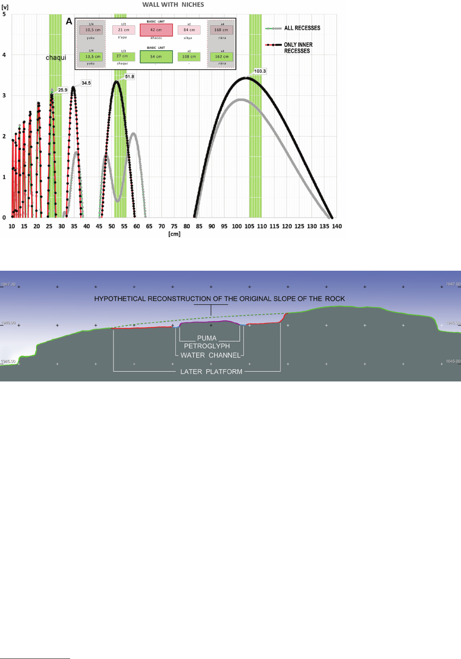
Since the modern reconstruction well follows original
dimensions, the Incan provenance of the wall can be fur-
ther conrmed using the cosine quantogram metrological
analysis of niches. When comparing dimensions of all the
recesses (Fig. 9), the results are inconclusive. However, if
we limit our investigation only to the inner small recesses,
the resulting quantogram matches units of measurement
typical for Incan buildings of high prestige, as proposed
by Anna Kubicka in her doctoral thesis [10].
Two other elements in this sector can however be at-
tributed to the pre-Inca period – the already mentioned
representation of the rhea in the western part and a cir-
cular depression in the eastern part of the sector. Of the
depression, only its eastern edge – a small, ca. 3 cm-high
step – can be identied, but this is enough to reconstruct
its diameter as ca. 4 m. No traces are left on the surface
of this depression that might point to its function. It is
too shallow to have been used only as a place to collect
rainwater, but perhaps it once housed another (gural?)
petroglyph in its centre. If so, this must have been entire-
ly erased by later occupants of the site – probably dur-
ing the same time that a T-shaped platform with a small
Fig. 7. Sectors W07 and W08
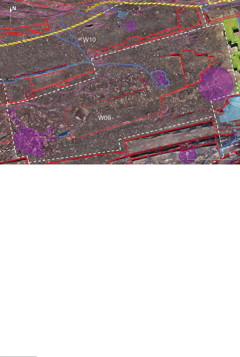
ElFuertedeSamaipatainthelightofnewresearch / ElFuertedeSamaipatawświetlenowychbadań 85
recess pointing to the east was carved. The outline of this
platform overlaps the reconstructed extent of the circular
depression. The petroglyph representing the rhea has also
probably been intentionally hammered out. Our attempts
to reconstruct it using vPTM and vRTI ended only with
a general suggestion about the size and orientation of the
gure. Generally, this suggestion is similar to the sche-
matic icon on d’Orbigny’s drawing (Fig. 6). There, the
gure of the rhea is shown in an entirely dierent manner
than all other petroglyphs, which, as we can see today, are
bas-relief. Can this dierence in the way of depicting the
rhea on d’Orbigny’s drawing mean that in this case, we
are dealing with a sunken relief? If so, this might be one of
the reasons that it has completely disappeared
8
.
The central part of sector W09 has been further re-
shaped during the last phases of occupation. A shallow,
Z-shaped platform cuts into the rock surface. In the middle
of the eastern, roughly square part of this platform, a rep-
resentation of another felid (possibly puma) is carved in
bas-relief. A at water channel surrounds it. This channel
continues further down the slope in a north-western direc-
tion (Fig. 8). A rounded hole (ca. 25 cm in diameter) drilled
into the rock in front of this petroglyph might have been
used for oerings. It seems that the petroglyph was created
together with the platform around it. The highest points of
the “Puma(?)” petroglyph are well below the reconstructed
8
Our attention was drawn to this possibility by Marta Pakowska.
line of the ridge of the rock from the time before the plat-
form was carved (Fig. 10). Thus, the wall with niches, the
Z-shaped platform, and the puma representation could all
be attributed to the period of Inca occupation of the site.
Another oering hole has been cut into the rock at the
western end of the Z-shaped platform, in front of the place
where the rhea is no longer extant. A small channel con-
nects it with a natural crack in the rock that is more than
35 cm deep.
Sector W10
Sector W10 forms a nearly horizontal platform (ca.
5 × 28 m) on the northern slope of the rock (Fig. 8). The
quincha wall already described marks the northern ex-
tent of the sector. Two steps starting on a nearly square
(ca. 2.5 × 3 m) platform in the south-western corner of the
sector probably facilitated movement between this sector
and sector W09 in the south, as there is nearly 1 m dier-
ence in height between these two sectors. The steps lead
directly to the area where the representation of the rhea
was once extant. This observation goes hand in hand with
our previous remark about the earlier provenience of this
petroglyph.
In front of the platform with steps, a water channel
ca. 6 m long and 0.5 m wide cuts into the surface of the
rock. It collects water running down from the puma petro-
glyph located in sector W09. The second branch of water
owing from sector W09 goes directly to the north and
splits into two streams.
Fig. 8. Sectors W09 and W10
86 Jacek Kościuk, Giuseppe Orefici, Mariusz Ziółkowski, Anna Kubicka, Rosario Muñóz Risolazo
The eastern part of sector W10 is organised dierently.
Although in the far east, there is a platform similar to that
found at the western end, the southern and northern bor-
ders dier. A ca. 50 cm-wide bench runs along the south-
ern edge. A small (ca. 1 × 1.5 m) platform or possibly seat
projects from the middle of this bench. In front of it, trac-
es of an extremely eroded petroglyph are extant. Again,
using vPTM and vRTI, we were able to identify this as
the representation of an animal that has caught a snake’s
head with its snout. Another snake is grabbing the tail of
the rst one, and yet another, emerging from a hole in the
rectangular centre of the whole scene, is catching the tail
of the second one. This complicated layout of four inter-
acting animals covers approximately 1 m
2
. It has no par-
allel on Samaipata rock. The representation of the main
animal is also very untypical and points rather to being
carved during the pre-Inca period. It does not resemble the
puma or jaguar petroglyphs on the rock
9
. An oering hole
9
Attempts to identify the species suggest that it is the white-nosed
coati (lat.: Nasua narica; local names: pizote, antoon, tejón), the only
similar animal from the area, known as a snake catcher. Cf. https://
en.m.wikipedia.org/wiki/White-nosed_coati [accessed: 15.03.2019].
(ca. 25 cm in diameter) accompanies this petroglyph in
the west.
The northern perimeter of sector W10 has further pe-
culiarities. Roughly adjacent to the snake-catching petro-
glyph described above, the quincha wall is split into two
parts running parallel for a distance of ca. 2 m. Between
them, traces of a channel directing water down the slope
are visible. The upper part of this channel is ca. 25 cm
wide and has well dened, straight edges. In the middle,
extremely eroded traces of yet another petroglyph repre-
senting a snake crawling up the slope were detected.
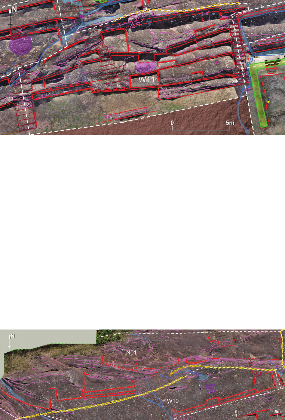
Sector W11
Sector W11 is located at the base of the opposite,
southern slope of the rock (Fig. 11). From the south, it
borders a at area covered with reconstructed remains of
Incan habitation [9].
In the west, the ight of steps already described for sec-
tor W07 separates these two sectors. Similar steps mark
the eastern extent of the sector. There, 18 narrow steps
(ca. 75 cm wide) climb to the north from the foot of the
rock. Traces of other, less regular steps are extant in the
middle of the sector. East of these, an oval shape protrudes
Fig. 10. North–south section across sector W09
Fig. 9. Cosine quantogram
analysis of the wall with niches.
A – The double system of Incan
units of measurement proposed
by A. Kubicka
[10, p. 171, ryc. 114]
ElFuertedeSamaipatainthelightofnewresearch / ElFuertedeSamaipatawświetlenowychbadań 87
10–15 cm from the surface of the rock. It is probably a rel-
ic of another petroglyph that is impossible to see today.
The presence of a small platform to the north of this shape
renders this interpretation even more likely.
Further to the north, irregularly arranged terraces and
platforms are probably the result of many modications
that the rock underwent during various phases of occu-
pation.
The southern area of sector W11 is divided into three
distinct units. Four double-recessed, square niches deco-
rate the face of the central part that protrudes to the south.
A narrow, 50 cm-wide bench continues to the west. The
back of the bench, which is ca. 75 cm above the bench level,
is decorated with eight small, square niches. To the east
of the double-recessed niches, a small platform (ca. 1 ×
2.5 m) cuts into the slope. A sequence of four, rectangular
terraces can be seen in the easternmost part of the area.
In front of the four double-recessed niches, there is
a 50 cm-wide and 3.50 m-long possible fragment of a wall.
Its eastern and western extents are not clear. It may be the
remains of the front wall of a roofed room that once exist-
ed in this place, but no conrmation of such a hypothesis
has been found in any of the archaeological reports.
Northern part of the rock
Sector N01
Sector N01 is located in the western part of the northern
slope of the rock, on the edge of the area covered with vege-
tation (Fig. 12). The sector comprises three dierent zones:
– A small plateau in the south-western part shaped as
a system of at-stepped terraces;
– A steep slope running latitudinally in the central part
of the sector at the foot of which traces of ve dierently
sized terraces are preserved;
– A at zone in the northern part that marks the north-
ern extent of currently identiable traces of anthropogenic
shaping of the rock.
The dierence in levels between the southern and
northern zones reaches 1.5 m in some places. In the steep,
Fig. 11. Sector W11
Fig. 12. Sector N01
88 Jacek Kościuk, Giuseppe Orefici, Mariusz Ziółkowski, Anna Kubicka, Rosario Muñóz Risolazo
eastern part of the slope, where the dierence in levels is
particularly signicant, six narrow, not more than 40 cm
wide, steps have been carved. They lead directly to the
foot of a quincha wall running along the upper edge of the
slope. Either they precede the construction of this wall,
or they were hewn in the rock when the wall ceased to
exist. They could also have been used only during the con-
struction of the quincha wall. The very negligent manner
of execution may speak in favour of the last interpretation.
In three places, at rainwater channels intersect sector
N01. They drain water from sectors W06, W10, and C02
located higher up the slope.
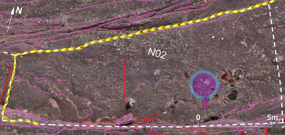
Sector N02
Sector N02 is a continuation of the lowest, at part of
sector N01 (Fig. 13). The quincha wall mentioned above
surrounds it from the north, west, and partly from the
south. The southern boundary is a steep, nearly 1.5 m-high,
cli that separates this sector from sector C02.
In the eastern, almost at part of sector N02, there
are relics of an indecipherable petroglyph in the form of
a round disk about 1.5 m in diameter. The disk was once
surrounded by a ca. 25 cm-wide water channel. The dif-
ference in elevation between the centre of the disk and the
surrounding channel does not exceed 10 cm. In the vicin-
ity, a few oering holes have been drilled into the rock.
The only other features of anthropogenic origin are a small
fault across the sector and the outline of a ca. 2.3 m-wide
platform at the foot of the cli.
Sectors N03 and N04
The topography of sector N03, which is located further
to the east, is similar to sector N02. Its northern border is
the continuation of the quincha wall traversing the slope
of the rock that descends towards the north (Fig. 14).
A terraced rock edge almost 2 m high marks the southern
border of this sector.
In the northern part of the sector, no traces of inten-
tional carving of the rock have been found. A sequence
of parallel natural cracks running east to west cuts this
sloping surface. In the higher, southern part of this sector,
three at terraces bear traces of intentional shaping. The
overall state of preservation of the rock in this sector does
not allow for a more conclusive interpretation of these
terraces. However, one can get the impression that the
layout of the terraces is a continuation of the layout of the
much more well preserved terraces in sector N04 located
to the east.
Sector N04 has a clearer layout (Fig. 14). The line of
circular holes that we interpret as traces of a quincha wall
again marks its northern border, while a more than 60 cm-
high, sharp step delimits its southern perimeter. Between
these two borders, four terraces are arranged. To the east,
they end at a narrow stairway ca. 70 cm wide. Seventeen
steps negotiate nearly a 3 m dierence in height between
the northernmost terrace of N04 and sector N05 located
further to the south.
The southernmost terrace in sector N04 is trapezoidal in
shape, but the remaining three are rectangular, and their per-
fectly parallel edges suggest one coherent concept of layout.
Sector N05
This sector (Fig. 15) has the shape of an irregular, elon-
gated, polygon (ca. 6 × 40 m). It is located on the northern
slope of the rock, just to the south of sectors above sectors
N04 and N06. The main elements of sector N05 are three
terraces, 2.5–3.5 m wide, falling gently towards the west.
The dierences in levels between terraces do not exceed
30 cm.
The most interesting element of this sector is the trace
of a rounded shape, located in the northern part of the sec-
tor, protruding 5–15 cm from the surface of the terraces.
Only one-quarter of the original shape has survived, but
it is enough to reconstruct the extent of the whole shape,
Fig. 13. Sector N02
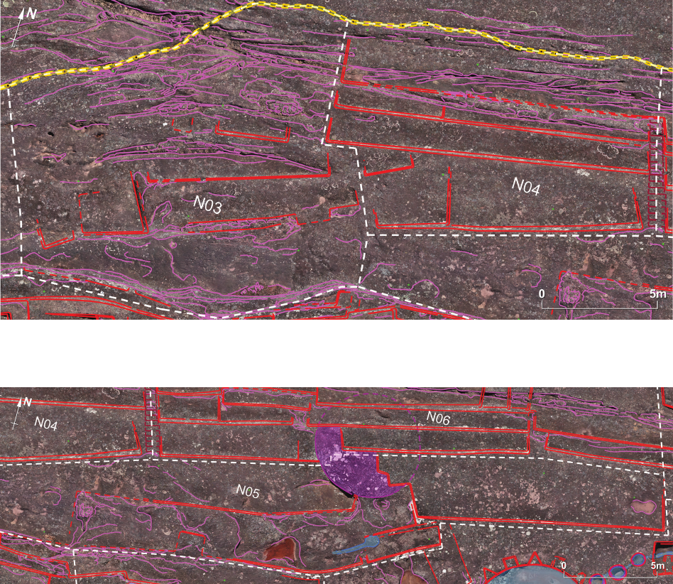
ElFuertedeSamaipatainthelightofnewresearch / ElFuertedeSamaipatawświetlenowychbadań 89
which must have been over 5.5 m in diameter. The re-
maining three-quarters of the shape was destroyed when
the eastern and western terraces of sector N05 and the ter-
races of sector N06 in the north were carved. Undoubt-
edly, this is a relic of an earlier phase of carving the rock
surface – probably the pre-Inca one. Perhaps the eastern
part of the central terrace of sector N05 belongs to the
same chronological phase.
There are no traces on the surface of the circular
shape clear enough to attempt a reliable reconstruction
of the petroglyph that may have been carved here. Local
height dierences (no more than a few centimetres) on
the shape surface suggest that there may once have been
a gural representation. It would have been one of the
largest known petroglyphs in Samaipata had it survived
to this day, comparable in size only to the “Choir of the
Priests” carving situated slightly further south-east in
sector C05.
Sector N06
Sector N06 (Fig. 16) is similar to sector N04. A long
set of steps separate both the sectors. The northern and
southern borders of sector N06 are respectively also the
quincha wall and the sharp step of the rock. Between two
and four terraces step down the slope in a northern di-
rection. Since the slope of the rock also inclines to the
west, some terraces are split into horizontal sections sep-
arated by steps 10–30 cm high. The surface of the lowest,
northern most terrace is disturbed by a series of parallel,
natural cracks running east to west.
The eastern boundary of the sector is marked by the
place where the last traces of the quincha wall vanish. It
should be stated, however, that the easternmost section of
sector N06 shows continuation with neighbouring sector
N07. The division is therefore arbitrary in this case.
Sector N07
Four dierent areas constitute this sector (Fig. 17): an
area alongside the sector’s northern border, ve platforms
in the centre that step down to the west, two spacious plat-
forms located to the south, the southern edge with a se-
quence of narrow shelves and two water reservoirs(?), and
an irregularly shaped platform at the westernmost end of
the sector.
Fig. 14. Sectors N03 and N04
Fig. 15. Sector N05
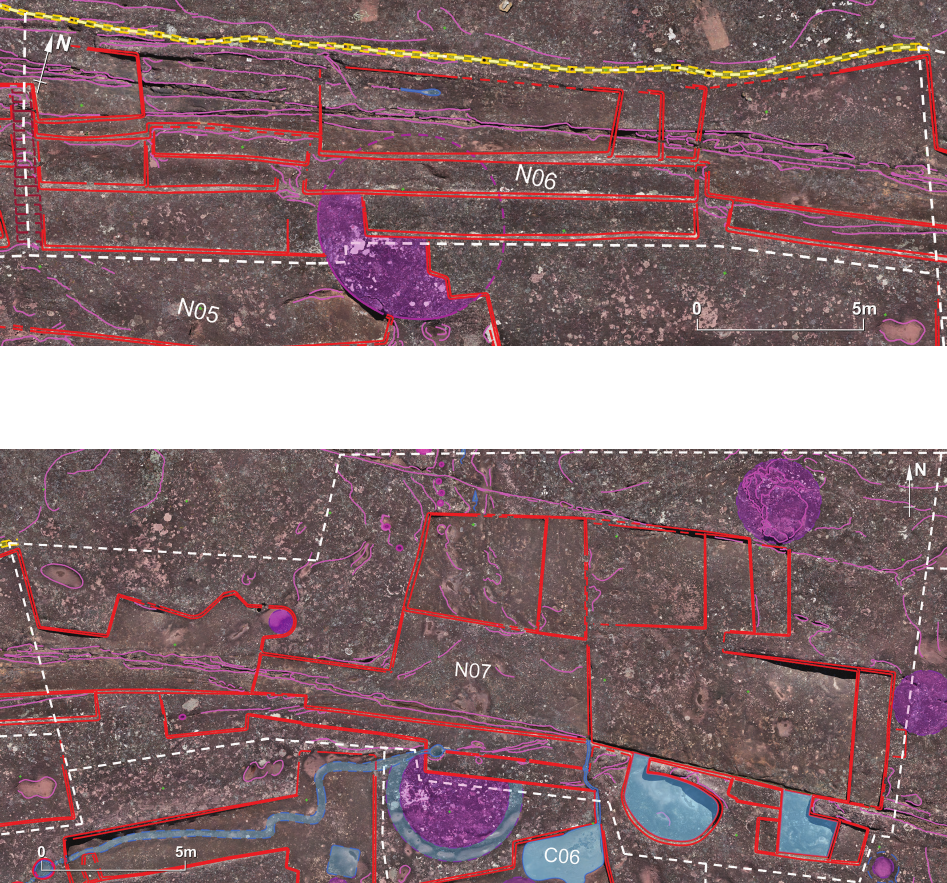
90 Jacek Kościuk, Giuseppe Orefici, Mariusz Ziółkowski, Anna Kubicka, Rosario Muñóz Risolazo
Two natural cracks cut the whole area. The smaller one
runs alongside the northern edge of the sequence of ve
platforms. The much deeper, southern crack is a continu-
ation of a series of ssures running alongside the northern
slope of the rock, already known from sectors N04 and
N06.
The northern, irregular edge of the westernmost plat-
form has no parallel on the whole rock, as all other plat-
forms are trapezoidal or rectangular in shape with angles
nearing 90°. It might be that this platform did not get n-
ished, thus can be associated with the last stages of the
rock being carved. The question of whether this was dur-
ing the last pre-Inca phase or the last stage of Inca activity
remains open. A semi-circular recess in the eastern part of
the platform looks, however, like it has been carved inten-
tionally. Very unclear traces suggest that once this could
have been a circular (ca. 60 cm in diameter) protrusion
raised a few centimetres above the surrounding surface –
perhaps another petroglyph.
The levels of all platforms in sector N07 have been
shaped so that rainwater ows towards the northern,
lowest platform, and thus down the slope (Fig. 18). This
observation also applies to two recesses, one elliptical
and the other L-shaped, cut into the southern edge of sec-
tor N07. The inclination of the bottoms of these recesses
excludes the possibility that they could be reservoirs for
collecting rainwater – any water on the bottom of both
recesses would have immediately owed to the lower
platform. Such a situation leads to the supposition that
both recesses were supposed to remain dry, even if water
was in use here. It is not possible to point to more spe-
cic functions that both recesses could have served, but
they could have been related to rituals in the “Choir of the
Priests” located about 25 m to the west, or more likely,
with rituals in sector C06 adjacent from the south.
Since the southern edge of sector N07 cuts into an
earlier circular petroglyph, a fragment of which can be
found in sector C06, we can conclude that the platforms of
Fig. 16. Sector N06
Fig. 17. Sector N07
ElFuertedeSamaipatainthelightofnewresearch / ElFuertedeSamaipatawświetlenowychbadań 91
sector N07 as well as the recesses came from a relatively
late, probably Inca phase of carving the rock.
In the north-eastern corner of sector N07, an irregular,
roughly circular protrusion can be interpreted as traces of
another petroglyph whose original form cannot be recog-
nised today. Its diameter was probably up to 3 m.
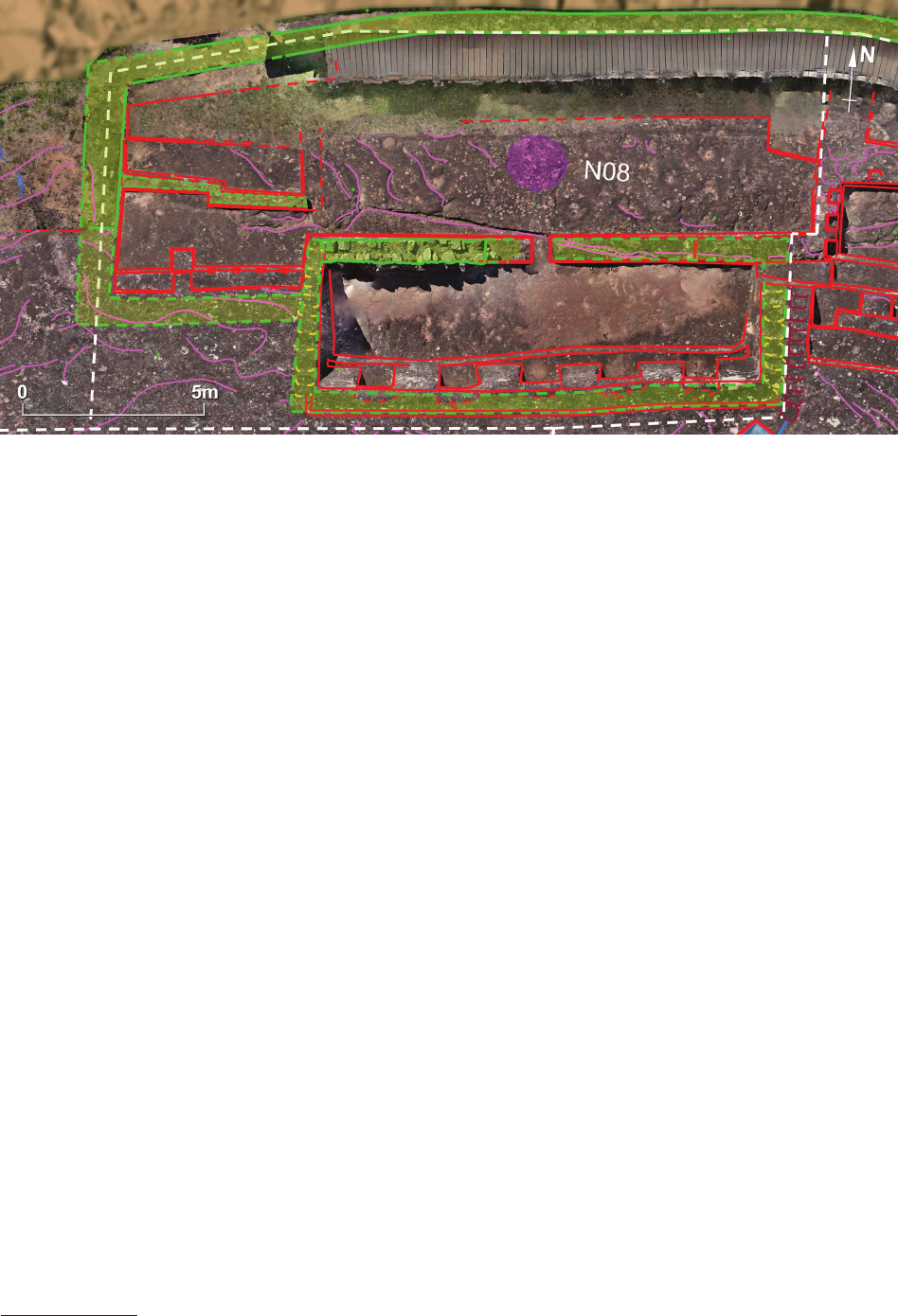
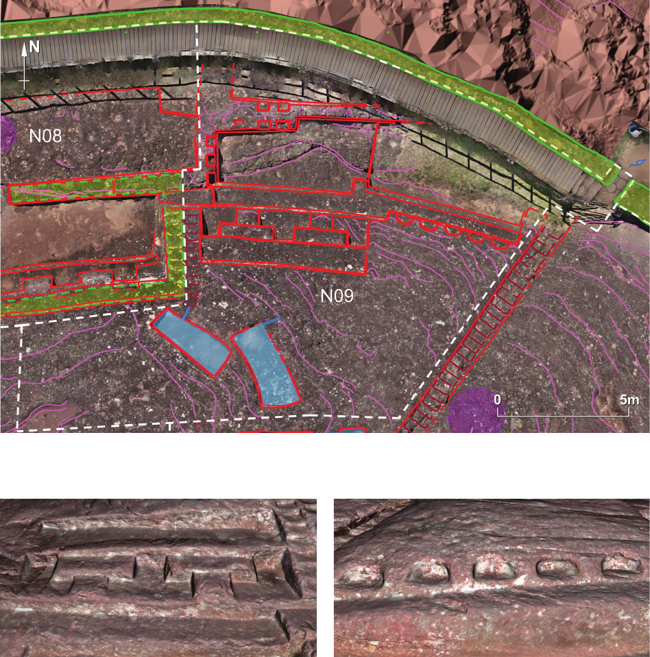
Sector N08
Sector N08 (Fig. 18) is located on the edge of a steep
northern slope and in the northernmost part of the rock where
traces of intentional human activity are still preserved. It
is one of the most architecturally interesting sectors.
Three distinctly separate units can be distinguished
here. The most important is that of what is known as the
“Temple of Five Niches”. It was once a roofed building
measuring ca. 5 × 13.3 m. From the northern side, its front
wall is still preserved. The lower part of it survived only
as a 25–35 cm protrusion from the rock surface. The upper
part is a ca. 60 cm-thick wall constructed from unshaped
stones with local soil as a binder. Although partially
reconstructed, the stone wall is still visible in the western-
most part of the temple front.
A narrow, ca. 50 cm-wide passage in the centre of the
front wall leads to the single room (ca. 2.5 × 11.5 m) of
this building. Its oor is a carefully levelled rock surface.
Additionally, the back wall of the room has been carved in
the natural rock. A well levelled bench, ca. 30–40 cm high,
extends for the whole length of this wall. In the upper part
of the wall, ve niches (0.99–1.07 × 1.70 m) are regularly
distributed. The back wall of the niches is semi-circular,
so their depth varies from 45 to 75 cm.
Metrological analysis
10
of the width of the niches and
the distances between them indicates that in the process
10
Again, the cosine quantogram method was used for metrological
analysis.
of their planning, a basic unit of measurement was used
whose metric value corresponds to 54.5 cm. This obser-
vation ts with the results of the metrological research on
the Machu Picchu sanctuary, indicating the use of such
a measurement in buildings of high prestige [10], and
conrms assumptions about the Incan provenance of the
“Temple of Five Niches”.
The natural rock on the rear side of the room extends
30–50 cm above the niches, so the total height of the back
wall of the room reaches 2.6 m in some places. On the
top of this back wall is a 60 cm-wide shelf with shallow,
irregular elliptical depressions – apparently troughs for
stone blocks of the upper-most part of the back wall of the
room. However, no single block has survived, and we do
not have any indication of the height of this extension of
the wall. We can only estimate that it was at least 40–50 cm
– just enough to put canopy beams over the entire room,
since there is no doubt that the building was once roofed.
In his study, Rolando Marulanda [11, p. 47, Fig. 25]
came to similar conclusions as ours given above. How-
ever, his hypothetical reconstruction assumes the exist-
ence of a gable roof. Due to the lack of a typical channel
draining rainwater from the southern roof slope, such a re-
construction seems doubtful. A single-pitched roof seems
more likely – similar to the one proposed by Boero Rojo
[12, p. 90, Fig. 45]. However, the latter reconstruction does
not take into account the existence of a stone front wall
of the building, and Rojo erroneously interprets its traces.
Irregular elliptical depressions (troughs for stone blocks)
are visible on the top of the side walls of the room. Due
to the nature of the slope of the rock, the tops of the lower
parts of the side walls that are carved in the natural rock
are also sloping. As a result, the troughs for the stones in
the side walls are similar to roughly cut steps. However,
they should not be confused with them. The real steps are
on the east side of the building and run parallel to the line
of troughs.
Fig. 18. Sector N08
92 Jacek Kościuk, Giuseppe Orefici, Mariusz Ziółkowski, Anna Kubicka, Rosario Muñóz Risolazo
In front of the “Temple of Five Niches”, a spacious,
roughly horizontal, platform (5.5 × 14 m) has been cut into
the rock. In the centre, in front of the entrance to the room
with ve niches, traces of another circular petroglyph
have been identied, but the poor state of preservation
prevents any attempts to identify the nature of this petro-
glyph. From the northern side, the platform is limited by
a reconstructed stone wall standing on the edge of the cli.
The eastern border is another protrusion that is 30–40 cm
higher than the surface of the rock and separates this sec-
tor from neighbouring sector N09.
To the west, the platform borders a group of four ter-
races separated by a Z-shaped protrusion. The three north-
ernmost terraces were probably open to the sky, while the
last one most likely functioned as a separate room, cov-
ered by a roof. The only entrance was from the east, at
the corner of the room – a feature not typical for Incan ar-
chitecture. It should be noted, however, that the traces al-
lowing for the hypothetical reconstruction of the southern
and western walls of this room are not as apparent as in
the “ Temple of Five Niches”, so the existence of a roofed
room here cannot be taken for granted.
The most interesting element in this part of sector N08
is the southern wall of the highest terrace, which, accord-
ing to our hypothesis, was roofed. The wall consists of two
parts separated by a rectangular projection. The smaller,
western part is devoid of decorations. In the eastern part,
however, four small niches (ca. 25 × 28 cm) with charac-
teristic double recesses have been arranged symmetrically
(Fig. 19). Here, too, metrological analysis indicates the
use of an Incan unit of measurement typical for high-pres-
tige buildings – this time, due to the smaller dimensions
(13.3 cm) of the niches, this is yuku [13] – a fractional
part of the previously identied unit of measurement [10].
This observation can be considered as further conrma-
tion that the relics in sector N08 relate to the Incan phase
of occupation of El Fuerte de Samaipata.
Sector N09
Sector N09 (Fig. 20) consists of three separate areas.
Remnants in the northernmost area form a T-shaped pro-
trusion elevated 20–40 cm above the rock surface. This
separates the sector from sector N08 in the west and at
the same time divides the lowest, northernmost unit of
this sector into two parts. Several small niches or seats
(ca. 30 × 45 cm) are preserved in this protrusion. Six of
them face a bigger, rectangular area (ca. 2.5 × 6.0 m) and
two others point to the north, where much smaller and less
regu
lar space has been arranged. The form and the way
this T-shaped protrusion has been carved into the rock are
very similar to the bottom part of the front wall of the
“Temple of Five Niches”. Perhaps, here too, it served as
a foundation for a stone wall that stood on it. However,
clear traces allowing for a convincing reconstruction of
the shape of the rooms that could have been separated by
such a wall are missing. Besides, it is highly possible that
either the original intention was abandoned or the original
form of this protrusion was disturbed by later work in the
central part of the area.
There, two distinct groups of rock carving can be dis-
tinguished. The bigger, more westerly located carving
con sists of three terraces (ca. 1.0 × 6.5 m) cut into the
northern slope of the rock. The middle terrace has a more
complicated form than the two others (Fig. 21). Two plat-
forms (ca. 52 × 206 cm), each roughly 45 cm high, are set
symmetrically against the back of the terrace. In front of
them, ca. 27 cm-high, rectangular steps (51 × 82 cm) are
placed. The surface of the rock is well nished there and
the edges of the platforms and steps are sharp and well
dened. All this gives the impression that skilled stone-
cutters worked on this area. Metrological analysis of main
dimensions reveals again a unit of measurement typical
for Incan architecture of high prestige
11
.
The lowest of the terraces described above continues
to the east. Approximately 10–15 cm above the surface
of this terrace, ve semi-circular seats (each ca. 60 cm
in diameter) have been carved in its rear wall (Fig. 22).
The semi-circular shape is somewhat surprising, as is
their upper part, which gives the impression of having
never been nished. It is, therefore, possible that work in
this area was abandoned. Perhaps the seats were intend-
ed to be rectangular, and their present shape is a kind of
semi-nished product – the rst stage of carving them.
Since metrological analysis again indicates the use of
units of measurement typical of Incan high-prestige ar-
chitecture, one can risk the hypothesis that the work was
interrupted in the last phase of Inca presence at El Fuerte
de Samaipata.
On the slope above the terraces to the south, traces of in-
tentional carving are limited to only two rectangular water
11
This time, the results obtained were more unambiguous than in
the “Temple of Five Niches”. Measurements of 13.8 [13.5], 26.0 [27.0],
and 50.3 [54.0] cm were detected. Incan units of measurement observed
by Kubicka [10] in the central part of Machu Picchu are given in square
brackets.
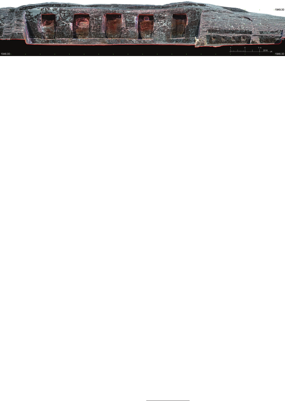
Fig. 19. Sector N08. The northern façade of the “Temple of Five Niches”. Ortho-image from TLS
ElFuertedeSamaipatainthelightofnewresearch / ElFuertedeSamaipatawświetlenowychbadań 93
reservoirs (ca. 1.1 × 3.1 m and 1.25 × 3.35 m). Their depth
does not exceed 7–10 cm. The outlet of the rst of them
leads towards the steps separating sectors N08 and N09.
The second reservoir discharges water to the slope above
the terraces located in the central part of sector N09.
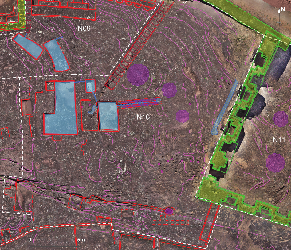
Sector N10
Sector N10 is located east of sector N09 (Fig. 23).
10 m-
long series of 26 steps, each less than 80 cm wide,
separates both the sectors. The eastern border of sector
N10 is an L-shaped wall decorated on both faces with
double-recessed niches.
The main feature of this sector is a group of three water
reservoirs located in the highest, north-western part. The
surface of the largest L-shaped reservoir exceeds 12 m
2
,
but the slope of its bottom and the elevation of the out-
let mean that it could accumulate at most about a quarter
of a cubic metre of water. Water overowing from this
reservoir ran to a much smaller one (0.9 × 1.3 m) located
on the eastern side, and then to another slightly larger one
(ca. 2.0 × 3.0 m). A small intermediate reservoir could act
as a sediment trap where all impurities owing down with
the water could accumulate.
The last of the reservoirs is also very shallow, and
taking into account the fact that its outlet is only 3–4 cm
above the bottom, it could not store more than about
150 litres of water. It supplied water to a carefully carved
channel on its eastern side. The preserved traces of this
channel allow its course to be traced to over a length of
ca. 4 m, but it was probably much longer. The bottom of
the channel has the form of a meandering snake. On both
sides of the channel are shelves about 25 cm wide on
Fig. 20. Sector N09
Fig. 21. Terraces in the central part of sector N09 as recorded with TLS
Fig. 22. Semi-circular niches in sector N09 as recorded with TLS
94 Jacek Kościuk, Giuseppe Orefici, Mariusz Ziółkowski, Anna Kubicka, Rosario Muñóz Risolazo
which a similar meandering pattern has been carved, but
this time as a bas-relief.
From the west, the lowest of the reservoirs is accom-
panied by a small platform (ca. 1.65 × 3.00 m) raised
around 0.5 m above the bottom of the reservoir. Poorly
decipherable traces preserved on the surface of this plat-
form may suggest that another zoomorphic petroglyph
once existed at this place [11, p. 38]. Due to the poor state
of preservation, attempts to reconstruct the form of the
petroglyph should be treated with extreme caution. It can-
not be excluded that the traces are the result of natural
weathering and erosion. This reservation also applies to
two round openings interpreted as oering holes – their
anthropogenic origin is not indisputably conrmed.
Marulanda also puts forward a hypothetical reconstruc-
tion of a building (a temple, as he calls it) erected on the
slope above the lowest reservoir and the accompanying
platform [11, Fig. 28, p. 50]. Similarly to the “Temple
of the Five Niches”, placing the walls of such a building
on a slope would require preparation of a proper base on
the ground (troughs for the lowest row of stones), so that
the foundation part of the walls would not slip down the
slope. No such traces can be found today, which makes
the whole hypothesis disputable.
Near to the reservoirs, almost entirely blurred edges of
subsequent recesses and small platforms or niches can
be observed. To the east of the reservoirs, there are also
traces of numerous oering holes and three circular petro-
glyphs. Their poor state of preservation prevents any in-
terpretation.
Traces of articially shaped surface are also extant in the
natural rock crack along the southern border of the sector.
Perhaps it was used as another channel to drain rainwater.
Sector N11
A few traces of pre-Hispanic activity can be found in
the area bordered from the west and south by an L-shaped
stone wall decorated on both faces with double-recessed
niches (Fig. 23). These include traces of two round petro-
glyphs in the western part that are hard to interpret, and
very eroded edges of two terraces in the eastern part. The
remains of a rectangular building (ca. 6–12 m) standing
in the central part of the sector were built during the His-
panic phase.
Fig. 23. Sectors N10 and N11
ElFuertedeSamaipatainthelightofnewresearch / ElFuertedeSamaipatawświetlenowychbadań 95
Central part of the rock
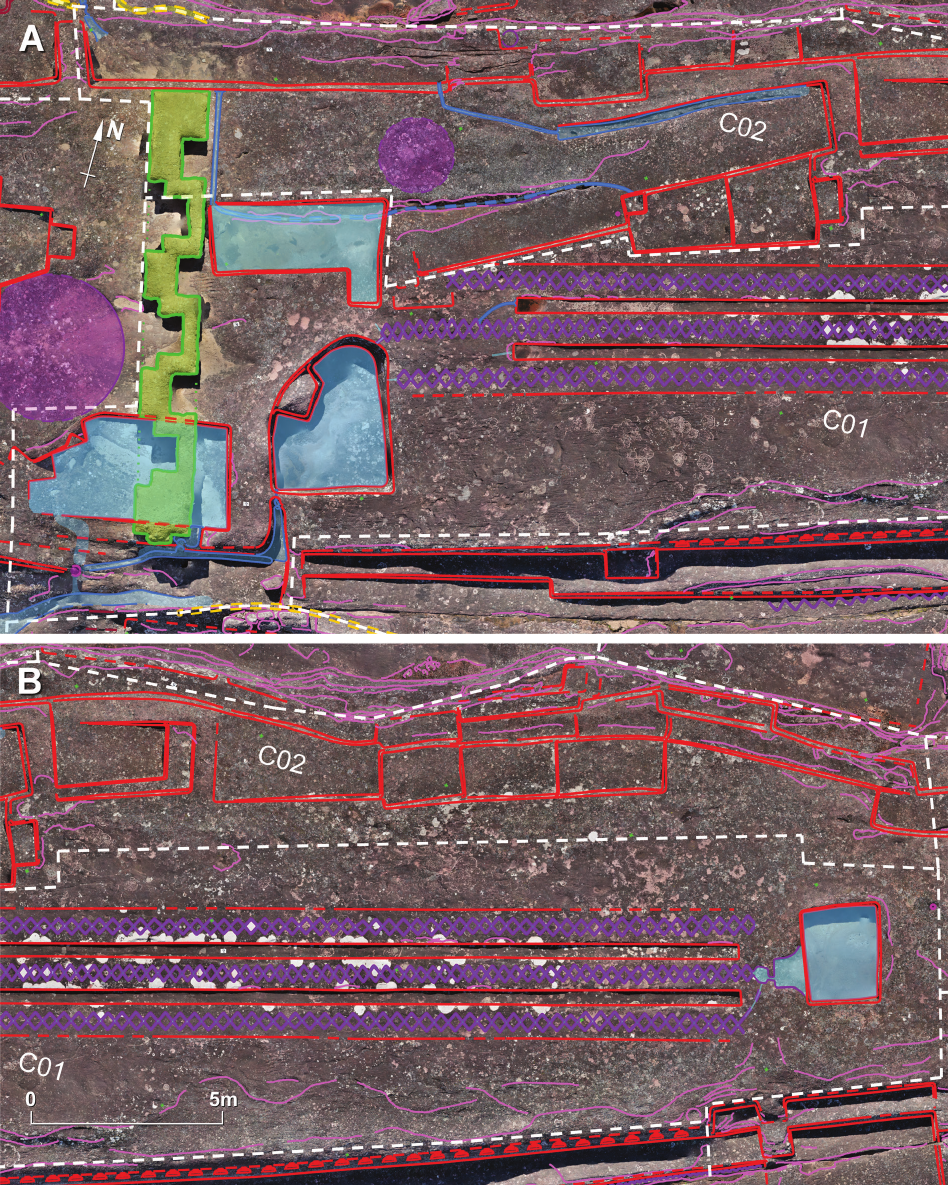
Sectors C01 and C02
Sector C01 (Fig. 24A, B) is located on the ridge of the
rock, east of a transverse wall decorated with double-re-
cessed niches. Three water reservoirs are located in the
westernmost, lowest part of this sector. Most probably, the
L-shaped northern one belongs to the later Incan phase of
carving Samaipata rock. It links with the sequence of shal-
low terraces in sector C02, from where it is also supplied
with water. In turn, the south-western reservoir, across
which the transverse wall decorated with double-recessed
Fig. 24. Sectors C01 and C02: A – the western part; B – the eastern part
96 Jacek Kościuk, Giuseppe Orefici, Mariusz Ziółkowski, Anna Kubicka, Rosario Muñóz Risolazo
niches has been built, is evidently of earlier origin and
might be associated with the remains of the circular petro-
glyph from sector W09. The third, south-eastern reservoir
has a semi-oblong form and is ca. 1 m deep. It could have
held nearly 10,000 litres of water if only the outlet in its
south-western corner was closed.
The last reservoir is part of a more signicant arrange-
ment called the “Big Snake” or “Rattlesnake”. The most
characteristic feature of this arrangement is three stripes,
each almost 30 m long, covered with rhomboid decora-
tions imitating the pattern on the back of a rattlesnake. Be-
tween the stripes, two channels have been cut into the rock
– both slightly shorter (ca. 26.8 m long), 36–30 cm wide,
and only 10–12 cm deep. The whole design is recessed
1–2 cm below the surrounding surface of the rock. This
creates additional shadows along the longer edges, em-
phasising the entire composition.
The rhomboid pattern is essentially a system of shallow
channels, 1–2 cm deep and ca. 2 cm wide. Water from the
reservoir (with a capacity of ca. 2,000 litres) located in the
highest, eastern part of the sector (Fig. 24B) could ow
into them. There are well-preserved traces of a shallow
channel facilitating supplying the middle stripe with wa-
ter. Slightly less well preserved is a small channel that
directed water to the southern stripe. Although the east-
ern end of all three patterns is well preserved, no traces
have been discovered of a channel leading to the northern
stripe.
The western ends of the stripes are in a much worse
condition. The northernmost is partially erased by shallow
terraces (and possibly steps) in sector C02, so there is no
evidence of where water running through it could have
been directed. The most extended stripe is the middle one.
It ends with a short channel directing water to the already
mentioned semi-oblong reservoir, as does the southern-
most one.
It is worth noticing that the geometry of each of the
rhomboid patterns diers, resulting in a dierent number
of rhombuses in each. Supposing that the western extent
of all stripes ended at more or less the same position, there
would have been 85 rhombuses in the northern stripe,
101 in the middle, and 81 in the southern one. These dif-
ferences could have had a signicant role if one assumed
that the whole system could have been used for magical
divination purposes. By knowing the number of shapes
in each of the patterns, it was possible to predict in which
of them water would appear rst at the western end when
simultaneously poured into their eastern ends.
Sector C02 (Fig. 24A, B) runs parallel to the northern
border of sector C01 described above. It consists of two,
and in some places three, levels of terraces located on the
southern slope of the rock. They descend towards the east.
Fig. 25. Sectors C03 and C04
ElFuertedeSamaipatainthelightofnewresearch / ElFuertedeSamaipatawświetlenowychbadań 97
The largest of them, located in the eastern part at the base
of the wall with double niches (Fig. 24A), has an elon-
gated, complicated shape and several interesting features.
Along its northern edge runs a channel draining water to
the next, lower level of terraces. A similar channel runs
along the southern border of the sector, but this time it
discharges water to the already mentioned L-shaped res-
ervoir. There are faint traces between both channels that
can be interpreted as relics of an earlier petroglyph that
existed here before this terrace was cut into the surface
of the rock.
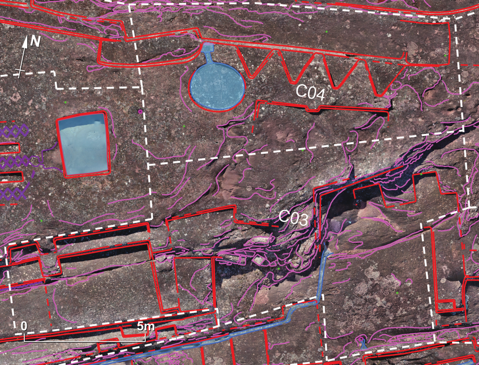
Sectors C03 and C04
Both sectors are located east of sectors C01 and C02.
The western part of sector C03 (Fig. 25) might be con-
sidered as a continuation of sector S12, but its character
is dierent. There are still two terraces descending south-
wards, but there are none of the double-recessed niches
that are characteristic for sector S12. This is also where
the petroglyph in the form of a meandering snake ends
after running for more than 20 m alongside the middle ter-
race of sector S12. Further to the east, the arrangement of
terraces is less regular, and the original layout is dicult
to identify due to the highly eroded surface of the rock and
many natural cracks that pass through this area. It is, how-
ever, evident that there, on a bigger platform located in the
eastern part of this sector, a long channel begins that runs
to the west alongside the northern border of sector S11.
Sector C04 occupies the northern part of the ridge of
the rock and descends in a northern direction in two ter-
raced steps. The most characteristic features are four tri-
angular recesses (or possibly seats) facing the north and
an oval reservoir located to the west of them. The recesses
have the shape of equilateral triangles with sides about
1.5 m long. The inside and outside corners are chamfered.
Although such recesses can be found in other sectors (for
example, W05, S10, S13, S14, S29, E01, and E02), their
character diers from the forms typical for Incan architec-
ture. Therefore, they might belong to an earlier phase of
the carving of Samaipata rock.
The oval reservoir has a diameter of about 2 m, and its
depth does not exceed 30 cm. The shape of the rock surface
in the immediate surroundings excludes the idea that this
place could have acted as a reservoir for rainwater ow-
ing there. Its bottom part is also slightly inclined towards
the north, where a channel leading to the lower terrace is
located. It could have served as a water reservoir only if
this channel was blocked o and water was poured there
manually.
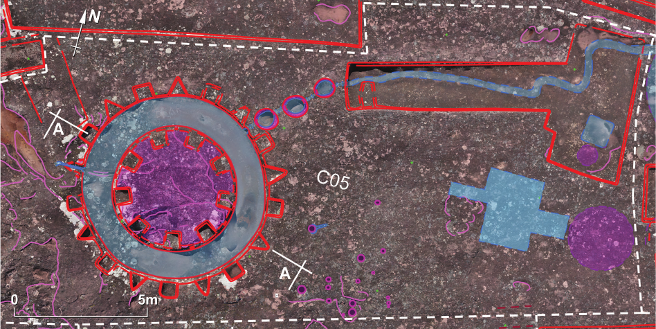
Sector C05
Sector C05 (Fig. 26) is situated on the ridge of the rock,
almost at the highest part of it. It is here that the most fa-
mous, symbolic petroglyph is located – the “Choir of the
Priests”. The main element of the whole composition is
a circular channel with an outer diameter exceeding 7 m
and a width of just over 1 m. It surrounds a central, circu-
lar section (diameter of about 4.75 m) which at the highest
point is raised about 75 cm above the bottom of the chan-
nel. The outer edge of the circular section is decorated
with nine square niches or seats (roughly 65 × 65 cm)
cut nearly 40 cm into the rock. On the vertical surface
between each niche, traces of small (15 × 15 cm) square,
double-recessed niches are extant.
Outside the circular channel, there is an alternating pat-
tern of nine square (also ca. 65 × 65 cm) and nine triangular
seats (or possibly recesses) that could have had a decorative
function. The latter are in the form of equilateral triangles
with sides of ca. 75 cm and they are embedded less deep-
ly into the rock surface than the square seats. The whole
arrangement, when looked at from above, resembles a so-
lar symbol, although solar symbology is not particularly
Fig. 26. Sector C05
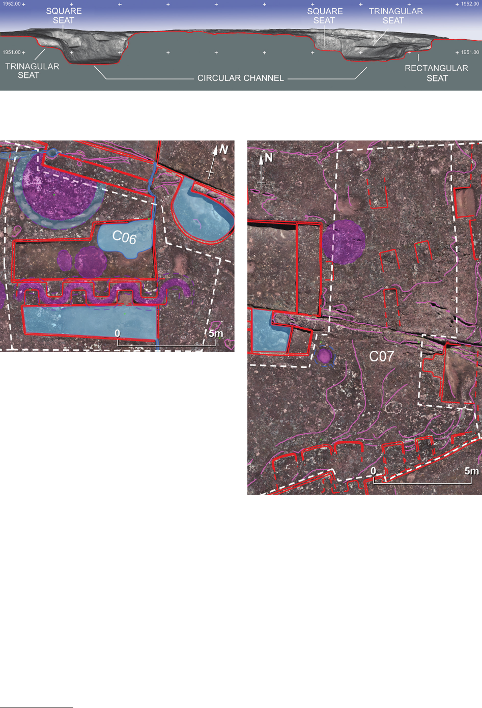
98 Jacek Kościuk, Giuseppe Orefici, Mariusz Ziółkowski, Anna Kubicka, Rosario Muñóz Risolazo
common in this region of South America. Much more typ-
ical for the area would be a representation of a feline. Very
weak trace of what once might have been such a symbol
preceding the sculpturing of the “Choir of the Priests” can
be seen in the central part of the sector (Fig. 27).
The bottom of the circular channel is inclined slightly
northwards so that the water that accumulates there ows
into a channel drilled below the surface of the rock. The un-
derground part of the channel is over 4 m long, and it does
not follow a straight line. This observation may explain the
function of three oval openings spaced evenly along this
channel – each of them with a diameter of at least 75 cm.
They were to facilitate drilling short, ca. 50 cm long, sec-
tions of the underground channel between the openings.
They may have also provided some ritual functions in the
celebrations performed here.
The channel leads to a T-shaped reservoir located in
the north-east of the sector. Its shape is connected to Pan-
American ancestral cosmological symbolism and is par-
ticularly common in the Amazonian area
12
. It is possible
that this reservoir that collects the water coming from the
“Choir of the Priests” was modied, and it erased some
older gures in bas-relief, of which we can still identify
12
One of the most characteristic examples can be found in Pantia-
colla in Peru.
some traces in its deepest parts (on its western and eastern
sides). A shallow meandering channel has been cut in the
bottom of this reservoir to direct the ow of water to its
north-east corner. Several round holes (10–30 cm in diam-
eter) are extant east of the “Choir of the Priests”. Further
to the east, very light traces of a cross-shaped water res-
ervoir are still preserved. Additionally, close to the border
with sector C06, a very low oval protrusion suggests the
remains of yet another petroglyph.
Sector C06
Two large water reservoirs are the main feature of this
sector (Fig. 28). From these, water drains to either the
southern or northern slope of the rock. On the bottom of
the northern, L-shaped reservoir, highly eroded traces of
two (or possibly only one) petroglyph are visible.
Fig. 27. Section A-A across the “Choir of the Priests”
Fig. 29. Sector C07
Fig. 28. Sector C06
ElFuertedeSamaipatainthelightofnewresearch / ElFuertedeSamaipatawświetlenowychbadań 99
The most interesting feature of this sector is evidence
of a large sculpture of a snake that separates both the res-
ervoirs. It has been modied, probably during the Inca
occupation, into a sequence of small niches or seats to
hide the original ophidian form. Three of the seats are
facing towards the north, and another three southward.
Once, the snakelike egy had its head directed to the
east, but it has been intentionally(?) erased after its shape,
as a symbol related to the cult of water, was deformed by
the abovementioned seats. It is possible that the faint trac-
es of the snake on the opposite, western side of the gure
are also its erased parts.
Remains of the one of the biggest round petroglyphs
(ca. 3.75 m in diameter) occupy the northern part of this
sector. It was split in half when platforms of neighbouring
sector N07 were sculptured.
Sector C07
Sector C07 (Fig. 29) lies where the top of the rock be-
gins to drop slightly eastwards. Only very faint traces of
one circular petroglyph on the border with sector N07,
and four, small rectangular platforms in the centre part,
remain. All of them, judging from their state of preserva-
tion and interference with evidently latter carvings, can be
attributed to the earlier, possibly pre-Inca phases of carv-
ing Samaipata rock.
On the southern margin of this sector, on the southern
slope of the rock, traces of six slightly better preserved
niches are extant. They seem to form two separate groups.
The three niches on the western side are roughly of the
same dimensions. The other three are narrower, but the
distances between them are wider. Both groups were
probably carved during two dierent phases, but there is
neither evidence of the sequence of their execution, nor
any hints to attribute them to the Inca or pre-Inca period.
Southern part of the rock
Sectors S01–S05
Sectors S01–S05 are located on the at area at the foot
of the southern slope of the rock. Four housing complex-
es can be identied there. They were examined in detail
during work by the German Samaipata Archeological
Research Project (Proyecto Arqueológico en Samaipata,
PIAS) [9]. According to the results of these investigations,
all of the housing complexes, except the central, U-shaped
group of buildings that is dated to the post-Conquest pe-
riod, were built during the Inca phase of occupation. All
these sectors are outside of the scope of this study, which
is limited to Samaipata rock itself.
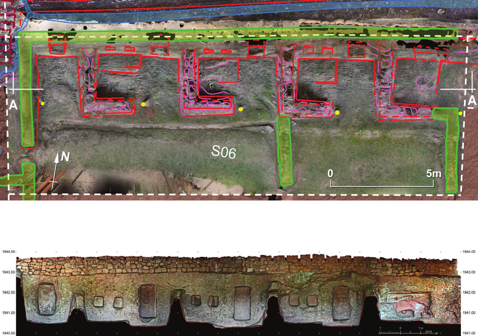
Sector S06
The architectural structures that constitute sector S06
are carved in the lithic wall at the base of the southern
slope of Samaipata rock (Fig. 30). They consist of ve
units that evidently were once roofed (Fig. 31). The roof,
Fig. 31. Section A-A across sector S06
Fig. 30. Sector S06
100 Jacek Kościuk, Giuseppe Orefici, Mariusz Ziółkowski, Anna Kubicka, Rosario Muñóz Risolazo
today convincingly reconstructed, rests on one side on
a wall built on the slope of the rock. The front side of the
roof is supported by single row of wooden posts.
The three central units, measuring roughly 4 × 2 m,
have a very similar layout. From the west and south, the
units are enclosed by an L-shaped wall. A more than 2 m
wide entrance provides access to each room. On the back
wall, opposite these entrances, rectangular niches (75–80
× 160–167 cm) have been carved. These are accompanied
by a pair of smaller (roughly 50 × 50 cm), almost square
niches or blind windows, under which platforms protrud-
ing ca. 25 cm from the oor level are located. It seems that
originally the oors of these units as well as the platforms
were sculptured directly into the rock. In the same way,
the L-shaped walls separating individual units were exe-
cuted, or at least their lower parts. The upper parts might
have been built as stone rubble walls.
The easternmost and westernmost units show dierent
layouts. The westernmost is smaller (only ca. 2 × 3 m),
and it lacks a front wall. On the centre of its back wall is
one rectangular niche without a platform in front of it. The
easternmost unit has undergone several modications.
From the west and south, it is enclosed by an L-shaped
wall analogous to the kind already described. However,
there is no access from this side. It has been blocked by
a later stone rubble wall and a new entrance has been
arranged from the east by pulling down a stone wall that
once existed there. The negative of this wall is still vis-
ible on the back wall of this room. The presence of the
platform in the north-western corner of the room suggests
that the back wall might have been arranged in a similar
way as in the three central units. Unfortunately, it has been
badly damaged by treasure hunters, so its original layout
cannot be unambiguously reconstructed. Originally, there
was clearly no large rectangular niche here, as can be seen
today. Preserved traces suggest one, ca. 2 m long and
50 cm high, niche placed ca. 80 cm above the mentioned
stone platform. This niche might have had extensions in
its lower part, so its shape resembles the letter “T”. The
lower part of the back wall is so badly damaged that such
reconstruction must remain only hypothetical.
Rectangular-shaped niches, and in some cases with
a kind of enthasis, are not typical for Incan architecture.
This kind of form is more related to Tiwanacota tradition
than to Inca. This whole sector is often referred as the
“Sacristy”.
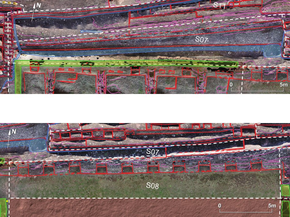
Sector S07
The main feature of this sector is a ca. 80 m-long ramp
enabling movement between western and eastern sectors
of the rock (Fig. 32). It runs just above sectors S06, S08,
and S09, and connects two ights of steps – the western
Fig. 32. Sector S07
Fig. 33. Sector S08
ElFuertedeSamaipatainthelightofnewresearch / ElFuertedeSamaipatawświetlenowychbadań 101
one located between sector W011 and S07, and the eastern
steps on the border between sectors S09 and S23. This
ramp, also played an important role in draining rainwa-
ter. Along its entire course runs a channel collecting water
from the terraces located above.
Sector S08
Sector S08 is located at the foot of the southern slope
of the rock (Fig. 33), east of sector S06. It seems that the
sculpting of this part of the rock began after the comple-
tion of sector S06, but this is only a technological phase;
it does not necessarily reect subsequent cultural chang-
es. From a formal point of view, sector S08 presents an
almost vertical wall, over 3 m high and almost 25 m long,
with 10 roughly rectangular niches carved at equal inter-
vals (Fig. 34).
The niches are slightly bigger than those of sector S06.
Their width ranges from 105 to 112 cm while their height
is between 180 and 200 cm. Their shape is however not
uniform. Some are nearly rectangular, in some cases we
can see a kind of enthasis in the middle, and one of them
is trapezoidal in shape. This variety of shapes does not
point to any specic period, but the overall impression is
similar to that of sector S06. Above this set of niches, the
long ramp leading from sector S07 continues in an eastern
direction
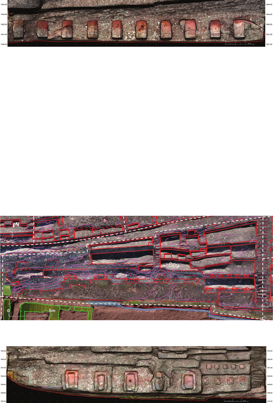
Sector S09
Sector S09 (Fig. 35) can be divided into two zones:
the lower one located at the foot of the southern slope of
the rock and the upper one stretching up to the long ramp
constituting sector S07.
In the lower zone, which is an almost vertical wall
2.3–3.5 m high, three separate groups of niches can be
distinguished (Fig. 36). The rst group adjoins the almost
11 m-long series of steps connecting the foot of the rock
Fig. 34. Front view of sector S08
Fig. 35. Sector S09
Fig. 36. Front view of sector S09
102 Jacek Kościuk, Giuseppe Orefici, Mariusz Ziółkowski, Anna Kubicka, Rosario Muñóz Risolazo
with the eastern end of sector S07. They are four small
(68–72 cm wide and 77–81 cm high) double-recessed
niches of a trapezoidal shape, which is characteristic of
Incan architecture. The front wall where these niches are
located is almost 6 m wide and ca. 2.3 m high, and n-
ishes with a nearly horizontal ca. 1.25 m-wide platform
from which the next slightly inclined wall extends by
ca. 1.6 m. Five smaller (49–54 × 54–58 cm) niches are
placed symmetrically on this wall, conversely to the lower
row of niches where only four are extant. This asymmetry
might be the result of a later modication in this sector.
In the central part of the 2.5–3.5 m-high wall, the front
wall is retracted by more than 1 m and three large (1.56–
1.59 × 2.35–2.45 m) double-recessed niches have been
carved here. They are rectangular rather than trapezoidal
and all of them have been altered in some way by robbers.
Nevertheless, the niches have the look of being never ful-
ly completed.
Further to the west, the front wall of sector S09 is again
retraced by ca. 0.5 m. Another two double-recessed niches
are placed there. Their width corresponds with the niches
from the central part of the wall, but they have a slightly
smaller height of between 2.29 and 2.34 m. Their shape is
even less regular, and the inner recesses also look unn-
ished. Perhaps the carving of the front part of this sector
was interrupted by the collapse of Incan control related to
the arrival of the Spaniards.
In front of all these three groups of niches are three at
platforms carved in the solid rock. From the south, they
are bordered by a channel draining rainwater. All three
platforms are located approximately 2 m lower than the
area directly to the west (sector S08). The dierence in
levels is overcome by narrow (ca. 60 cm wide) steps con-
necting both sectors.
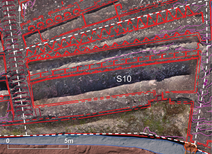
The upper zone of sector S09 consists of a sequence
of irregular terraces that climb up a further 5 m until they
reach the eastern end of the ramp in sector S07. At least
ve platforms are furnished with niches or seats that vary
in size. Four of these platforms are in the eastern part of
this zone, which is separated from its western counterpart
by a long, ca. 4.5 m, sequence of steps that also leads to
the ramp in sector S07. It seems that these steps may be
from an earlier time than the three groups of niches in the
lower zone, which are clearly from the Incan period. The
inclination of these steps may correspond to the original,
virgin slope of the rock from the period before rst terrac-
es and platforms were cut in.
It looks like in this area, the base of the rock underwent
decisive changes, most probably in the Inca epoch. How-
ever, the possibility that some of these modications were
made during the Chané occupation of the site cannot be
excluded.
Sector S10
Another unnished part of Samaipata rock can be
found in sector S10 (Fig. 37), directly to the east of the
steps separating this sector from sector S09.
There might have been similar steps on the eastern bor-
der of sector S10, but the highly eroded rock surface in
this area render a convincing interpretation impossible.
A room more than 13 m long and 2 m wide is located in
the lowest, southern part of the sector. The room was cut in
into the slope of the rock, so its roughly horizontal oor is
solid rock. The lower part of its southern wall, which is more
than 1 m wide, was sculptured into the solid rock. There are
no indications as to whether the upper part of this wall was
ever built, but evidently the intention was to build it, like
in other cases, from unshaped stones set on clay mortar.
The entrance, less than 70 cm wide, that leads to this
room is decorated with double-recessed jambs that point
to an Incan origin and the importance of this room. Two
shallow steps are placed in the entrance passage.
Fig. 37. Sector S10
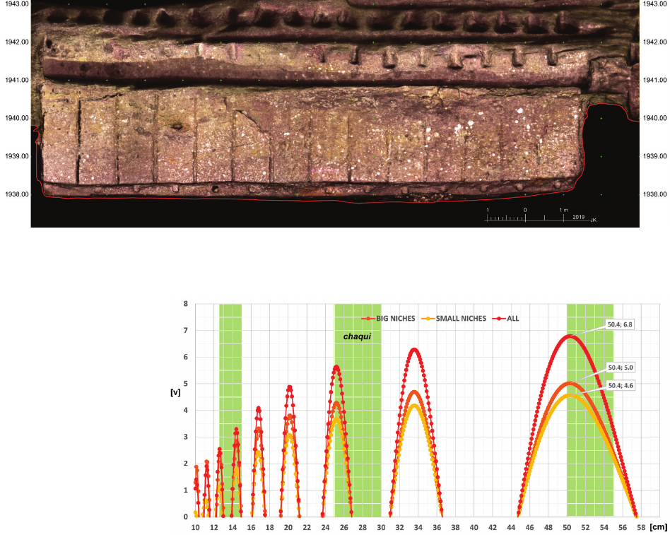
ElFuertedeSamaipatainthelightofnewresearch / ElFuertedeSamaipatawświetlenowychbadań 103
On the back wall of the room, which is nearly 3 m
high, several vertical grooves (6–7 cm wide) are placed
in nearly equal intervals ranging from 95 to 105 cm. The
most plausible interpretation is that the grooves mark the
edges of niches that were planned to be carved there but
were never nished. A small bench (ca. 30 cm wide and
ca. 40 cm high) runs alongside the base of this wall. On
the vertical face of the bench, a sequence of small square
(ca. 17 × 17 cm) niches has been carved – nearly perfectly
in between the ends of the grooves above (Fig. 38). Mis-
alignment does not exceed 1.5 cm.
When applying the cosine quantogram method for ana-
lysing distances between grooves marking the edges of fu-
ture big niches and the distances between the centres of the
small square niches below, we nd a unit of measurement
of 50.4 cm, which might have been used to lay out their
plan (Fig. 39). According to Kubicka’s studies on Machu
Picchu metrology [10, p. 171–175], units of measurement
between 50 and 55 cm are typical at Machu Picchu for
high-prestige buildings. This observation ts well with the
entrance adorned with double-recessed door jambs.
On the back wall of the room, which is nearly 3 m high,
several vertical grooves (6–7 cm wide) are placed in near-
ly equal intervals ranging from 95 to 105 cm (Fig. 38).
The most plausible interpretation is that the grooves mark
the edges of niches that were planned to be.
We can presume that this room was planned to serve
some important functions. As such, it was undoubtedly
intended to be roofed – probably with a one-pitched roof
sloping south. The shelf, almost 1 m wide, above the back
wall of the room could have been successfully used to
support rafters whose other ends would have rested on the
front wall. This room has several features that suggest it
was built during the Inca occupation of the site. The fact
that it was never completed suggests that construction
may have been interrupted due to the fall of Inca rule in
these areas.
Two terraces, nearly 15 m long, located in the upper
part of sector S10 are decorated with rows of triangular
recesses. Although triangular recesses are not foreign
to Incan architecture [14], these decorative patterns are
probably of earlier, pre-Incan origin. The lower terrace is
decorated with 17 small (ca. 50 cm wide and 30 cm deep)
triangular niches. A total of 18 much bigger and deeper
(ca. 80 × 70 cm) niches decorate the upper terrace.
Sectors S11 and S12
Sectors S11 and S12 lie in the central part of the south-
ern slope of the rock, to the north of sector S07 (Fig. 40).
Together with the latter, they form three long, east-rising
ramps connecting sectors located in the western and east-
ern parts of Samaipata rock.
Fig. 39. Cosine quantogram
analysis of niches in the back
wall of the room in the lowest
part of sector S10.
Green areas mark the Incan units
of measurement found by
A. Kubicka [10, pp. 171–175]
as typical for high-prestige
buildings at Machu Picchu
Fig. 38. The back wall of the room in the lowest part of sector S10
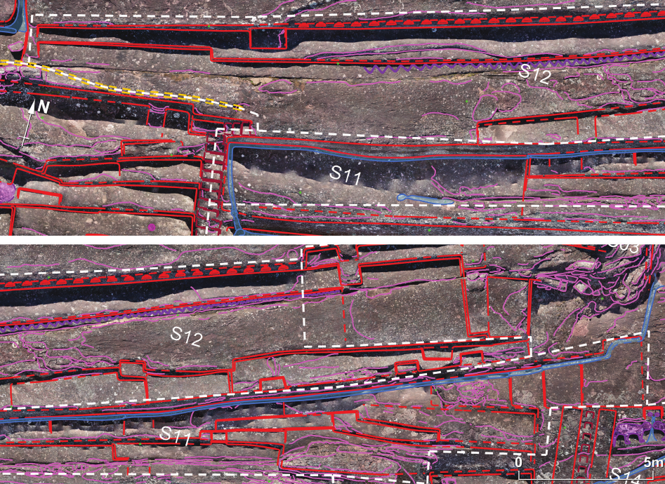
104 Jacek Kościuk, Giuseppe Orefici, Mariusz Ziółkowski, Anna Kubicka, Rosario Muñóz Risolazo
The steeply rising, over 38 m long, sector S11 is di-
vided by a series of terraces that help overcome a height
dierence of over 5 m between the sector’s eastern and
western ends. Along the rear wall of this sector, which is
over 2 m high, there is a channel draining rainwater from
sectors C03 and C04. Next to the series of steps consti-
tuting the western border of sector S11, this channel con-
nects to its counterpart in sector S07.
Sector S12 (Fig. 40) lies ca. 1.8 m higher than sector 11.
It has a similar length to its southern neighbour, but it is
much wider. In the middle, its width exceeds 4.5 m. A series
of ve narrow (1–1.5 m wide) irregular platforms rising east
have been cut into the southern edge of the sector, except
in the western end. Another platform (0.5–1.3 m wide) runs
alongside the sector’s northern border, at the foot of a near-
ly vertical wall ca. 2 m high that separates this sector from
the ridge of the rock (sector C01). This platform rises not
more than 15–20 cm above the central part of the sector.
Along the southern edge of this platform runs a narrow, at
least 21 m long, meandering channel resembling a crawl-
ing snake. Originally, it was probably much longer, but its
western part has vanished due to rock erosion.
There are 34 square, double-recessed niches evenly dis-
tributed on the vertical surface of the already mentioned
back wall. They are all severely eroded, so their dimen-
sions can be only roughly estimated as around 30 × 30 cm.
The average distance between the niches is 63.7 cm, which
with a good approximation corresponds to three values
of the Incan yuku unit of measurement
reconstructed as
12–14 cm [13]. This observation, along with the distinc-
tive, double-recessed niches, may again indicate Incan
origin. At the western end of sector S12, alongside its
southern edge, are four round openings (ca. 13.5 cm in di-
ameter) very reminiscent of the holes for the posts of the
quincha wall located on the northern slope of the rock. Per-
haps a similar structure was also erected here.
Sector S13
Sector S13 (Fig. 41) is located to the north of the cen-
tral part of sector S07, and consists of several roughly
horizontal platforms elongated in an east–west direction.
The lowest platform, which is not more than 1 m wide,
runs alongside the southern border of the sector and is
elevated roughly 2 m above the surface of sector S07.
Above the western end of the lowest platform, three seats
(ca. 90 × 60 cm) are overlooking the plaza in front of the
“Sacristy” (sector S06). The seats are separated by pro-
trusions ca. 1.15 m wide projecting from the back wall of
the platform.
The uppermost platform borders sector S14 and consist
of two sections. The most interesting is the western one.
Its distinguishing feature is a set of ve triangular recesses
(or possibly seats) attached to each other. Small (30 × 60 cm)
steps are in front of each seat. This part of sector S13 is
Fig. 40. The western (A) part and eastern (B) part of sectors S11 and S12
B
A
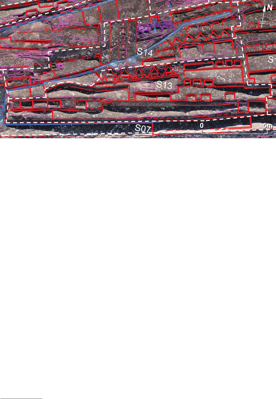
ElFuertedeSamaipatainthelightofnewresearch / ElFuertedeSamaipatawświetlenowychbadań 105
likely to be of an earlier, pre-Incan origin but triangular
niches are also known in Incan architecture [14].
The eastern section of the northernmost terraces con-
sists of small platforms with two sets of small, triple seats
– one in the upper, north-eastern corner and the other in
the lower, south-western corner of the platform. Between
the uppermost and the lowest platforms, there is an irreg-
ular arrangement of single and double seats – all looking
to the south.
Sector S14
Sector S14 is located up the rock, directly above sector
S13 (Fig. 41). A channel that diagonally crosses the slope
from the north-eastern corner of this sector and terminates
with a small cascade at the westernmost end divides the
sector into two parts. At the western end of the channel,
water runs down from a height of almost 2.5 m into a shal-
low pool at the foot of the rear wall of sector S07.
The most spectacular feature of the upper part of this
sector is the well-known representation of two felines (pu-
mas?) facing each other. A small (45 × 70 cm) rectangular
depression above the heads of the felines resembles the
face of a creature (possibly a feline head as seen from the
front) from whose mouth originates a channel leading be-
tween the heads of both pumas
13
.
Two at gutters 65 cm wide border the “Double
Puma(?)” petroglyph on its western side. Both of them ter-
minate with two elliptical pools along the channel run-
ning below the petroglyph. Between the gutters, a ca. 35 cm-
wide ight of steps has been cut into the rock surface.
Similar steps might have once existed further to the west,
but the degree of rock erosion does not allow for unambig-
13
Cf. J. Kościuk, M. Ziółkowski, M. Pakowska, Formal and ico-
nographic analysis and interpretation of the most damaged petroglyphs,
in the same issue of “Architectus”.
uous interpretation there. West of these gutters and steps,
alongside the channel, a series of irregular platforms and
seats are extant.
It is dicult to unequivocally interpret whether both of
the elements described above (“Double Puma(?)” petro-
glyph and two gutters with accompanying steps) were
carved at the same time, or were created and functioned in-
dependently. Nevertheless, both of the elements had a very
great signicance in the liturgical life of Samaipata, as can
be attested by their predominant position on the southern
slope of the rock, in front of the terraced plaza located below.
The south-eastern section of sector S14 (below the
diagonal channel) consists of three rows of platforms.
The most spacious (ca. 1.20 m deep) is the southern one.
A nearly 1 m-wide protrusion divides it into two equal
parts. Three narrow (ca. 50 cm wide) platforms extend
west of it. The highest platform is only partially preserved.
The diagonal channel cuts its western part.
The middle platform has the form of a set of ve trian-
gular recesses (or possibly seats). They are slightly smaller
than those in the neighbouring sector S13. It is possible that
this sequence of triangular recesses once extended further
to the west, but later on, one of the platforms neighbouring
from the west (that split by the channel) was cut into it.
The last, northernmost platform consists of four rectan-
gular seats separated by narrow (ca. 20 cm wide) protru-
sions. The area gives the impression of being of an earlier
origin. At the western end of this platform, there are traces
(just the corner) of the next seat, but the diagonal channel
has disturbed it.
To summarise, one can speculate that the oldest part of
this sector is the set of triangular recesses and perhaps the
platform above them with the series of rectangular seats.
The next chronological group would be the set of three
narrow platforms, the northernmost one cutting into the
triangular recesses. The diagonal channel that disturbs
Fig. 41. Sectors S13 and S14
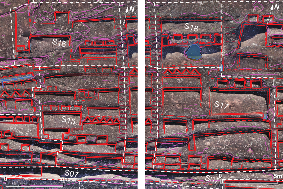
106 Jacek Kościuk, Giuseppe Orefici, Mariusz Ziółkowski, Anna Kubicka, Rosario Muñóz Risolazo
both the set of rectangular recesses in the uppermost
platform and the three narrow platforms on the western
side probably constitutes the third chronological phase.
The chronological relationship between the “Double
Puma(?)” petroglyph (together with the two gutters and
steps to the west) and the diagonal channel is not clear. Since
the cult of water and venerating felines go well together in
Andean cultures, both the parts are ideologically and func-
tionally combined. However, there is no physical evidence
conrming that both were actually executed together.
Sectors S15 and S16
Sectors S15 and S16 (Fig. 42) border sectors S13, S14,
and sector C03 in the west. The eastern edge of both sec-
tors is a 12 m-long series of steps leading from the top of
the rock down the slope. However, these steps reach nei-
ther the base of the slope nor even the ramp of sector S07.
They could have served to enable movement between the
signicant petroglyph the “Choir of the Priests” located
in sector C05 on the top of the rock and sectors S15–S18
below, thus they would have played an essential role in the
rituals performed there.
Sector S15 is a complex system of platforms, seats, and
recesses. It does not give the impression of being a homo-
geneous creation, but looks rather like the result of many in-
dependent activities not necessarily far apart in time. How-
ever, among this rich diversity of forms, some elements
are particularly striking due to their thoughtful layout.
Two symmetrically placed rectangular seats separated
by a protrusion nearly 1 m wide are extant in the lowest
part of the sector. Above these is another set of ve trian-
gular recesses (seats?) with a broad platform in front of
them. West of this platform is an even broader platform
with four nearly uniform rectangular seats placed above it.
The last interesting feature is a small platform located di-
rectly to the west of the two symmetrical, rectangular seats
in the lower part of this sector, just on the edge of a 1 m-high,
nearly vertical rock fault. Two recesses were added to the
back of this platform, giving the platform an unusual T-like
shape. The uppermost platforms bordering sector S16 no
longer give the impression of a thoughtful layout, although
they are also equipped with one or two rectangular seats.
Sector S16 (Fig. 42), located further up the rock, bor-
ders sector C05 in the north and it does not have a consist-
ent layout. Only in its south-eastern corner is one deliber-
ately planned feature. Three rectangular seats are placed
30 cm above two narrow, only ca. 35 cm-deep platforms,
which look like they may have been wide steps.
Sectors S17–S20
Sectors S17 and S18 (Fig. 43) are on the eastern side of
the long steps leading down from sector C05. In the east,
they border two dierent sets of steps separating them
from neighbouring sectors S19 and S20.
Sector S17, located further in the south than sector S18,
consists of several platforms of dierent sizes and shapes.
However, it can be divided into three groups showing some
common features and traces of a more orderly layout.
Two small trapezoidal platforms separated by a cen-
trally placed 1 m-wide projection are located on the steep
Fig. 43. Sectors S17 and S18Fig. 42. Sectors S15 and S16
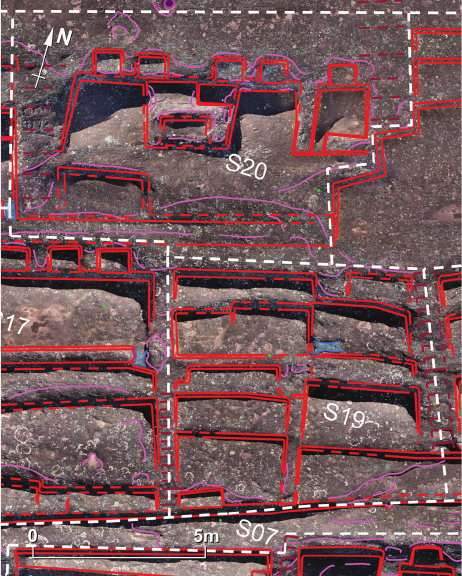
ElFuertedeSamaipatainthelightofnewresearch / ElFuertedeSamaipatawświetlenowychbadań 107
edge to the north of the long ramp of sector S07. West
of these, the same design is repeated twice, although on
a much smaller scale.
Each of the two terraces lying above the trapezoidal
platforms is divided into unequal parts by very eroded
ledges 60 cm wide – perhaps relics of two steps used to
negotiate the relatively large dierence in levels between
the terraces. A similar ledge separates two spacious plat-
forms located above these terraces. To the west, four trian-
gular seats with two descending platforms in front of them
is the next important feature of sector S17. Particularly
interesting is, however, the eastern platform. Three deep,
rectangular recesses are set into the wall behind the plat-
form at regular intervals. At the same time, the southern
edge of the platform is raised ca. 15–20 cm.
Using analogies with some constructions at the foot of
the southern slope of the rock (sectors S06, S27, and prob-
ably W11) and with the “Temple of Five Niches” (sector
N08 on the northern slope), one can conclude that this
platform was once walled up and probably also roofed.
In this case, the traces on the eastern and western sides
of this platform should be interpreted not as steps, but as
foundations for the upper part of the structure built of rou-
ble stones.
Located to the north of sector S17, sector S18 (Fig. 43)
is an example of a homogeneous complex with a clear
layout. Its main feature is the set of three equal rectangular
seats raised above the platform in front of them. Two deep
recesses on both sides complete this symmetrical design.
An irregular hole cut into the rock surface in front of the
middle seat seems to be a later addition.
Sector S19, situated east of sector S17 and to the north
of the long ramp of sector S07 (Fig. 44) has a very uni-
form plan. In its lower part, a narrow strip running from
north to south and raised above the neighbouring plat-
forms separates three pairs of terraces. Located above
this, another pair of platforms is devoid of such a parti-
tion. It appears again in the highest part of the sector, but it
is much broader here and both terraces dier signicantly
in width. Except for a small recess in the south-western
corner of the lowest terrace, no other special features like
seats or benches can be found in this sector. Most likely,
the whole of sector S19 was created from one concept,
and it probably comes from the same period as the adja-
cent sectors of S17 and S21.
Sector S20 (Fig. 44) shows a much more appealing
layout. A big seat measuring ca 1.90 × 2.60 m can be
found in the centre of the back wall of its only platform.
The sides and back of this seat are raised, so it resembles
a large stone armchair. Behind it, a deep rectangular re-
cess has been cut into the rock. Two pairs of rectangular
recesses (ca. 70 × 90 cm each) have been cut into the back
wall symmetrically on both sides of this undoubtedly cer-
emonial seat. This symmetry is additionally emphasised
by steps anking the platform on both sides. They en-
abled movement to sector C05, where one of the most
important elements of the rock is located – the “Choir of
the Priests”.
In the middle of the eastern part of this sector, there is
a small (ca. 1.2–1.5 m) space. It is adjacent to small steps
separating this sector from neighbouring sector S22. The
front and western edges of this area are raised, and the
only passage is in the south-western corner. In the back
wall of this “room”, a single recess is centrally placed.
Its size is similar to the recesses adorning the ceremonial
seat. Probably, this “room” was associated with some cer-
emonial rites performed on the platform.
Sector S20 is one of the best sectors for allowing us to
understand the principles of composition that the builders
were guided by, and their attempts to construct possible
functional relationships with neighbouring elements. It is
also preserved in almost complete shape. A small recess
in the south-western corner of the sector may have been
added later. The south-eastern corner was also slightly
modied by a large platform in sector S22 that was anoth-
er later addition.
Sector S21
Sector S21 (Fig. 45) occupies the east–west extended
area at the eastern end of the long ramp of sector S07. It
is accessible by the steps leading down from sector S22
located further to the north. This sector does not have any
regular layout. It consists of sequences of many irregular
terraces, platforms, and recesses. Its present state is rather
the result of many transformations that have altered the
southern slope of the rock.
However, two parts of this sector are particularly inter-
esting. The rst is a trapezoidal platform located across
from the beginning of the steps leading up from the foot
of the rock. Three rectangular recesses have been sym-
metrically cut into its rear wall. This part of the whole
complex distinguishes itself as it seems to have a regular
Fig. 44. Sectors S19 and S20
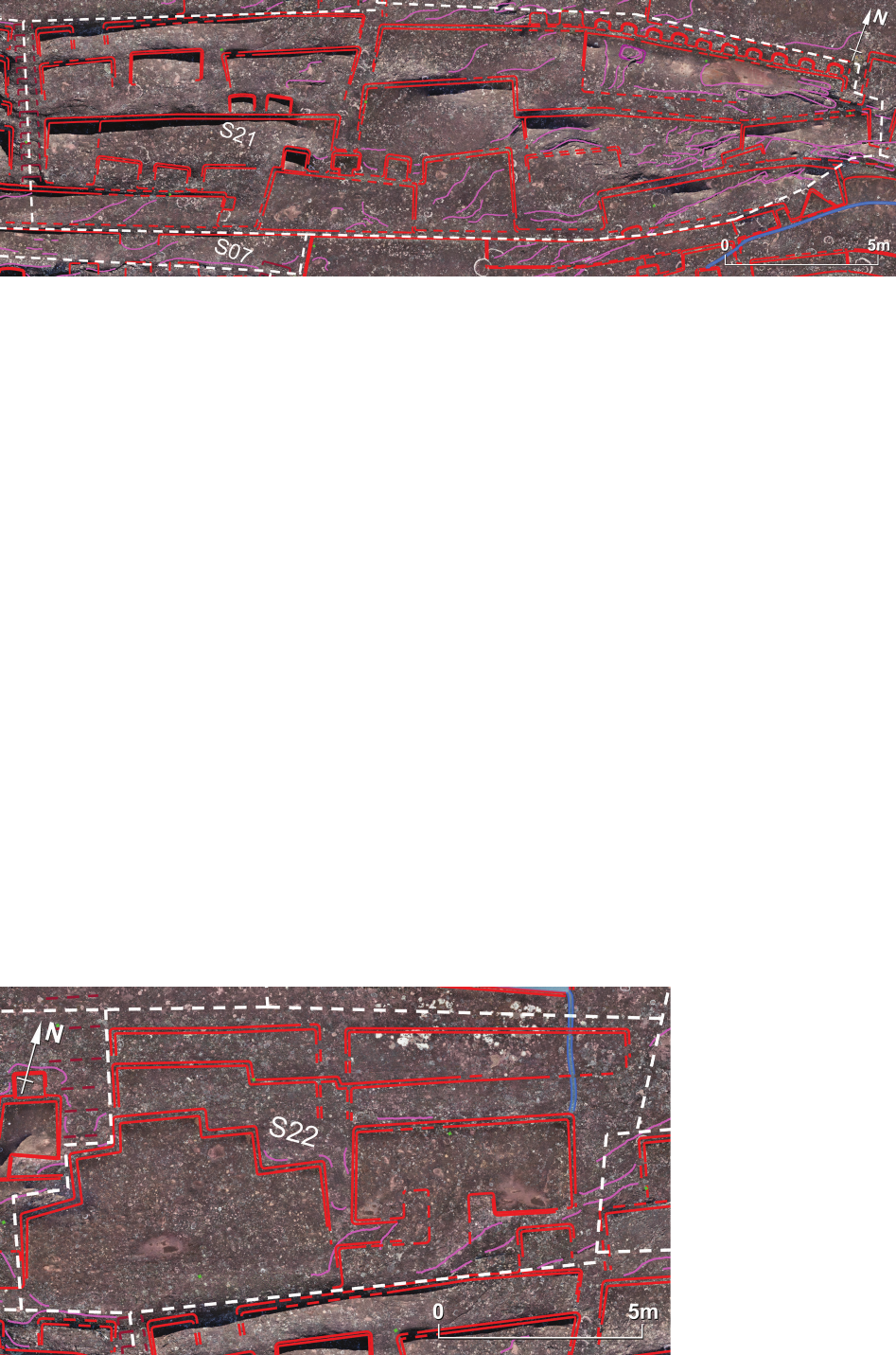
108 Jacek Kościuk, Giuseppe Orefici, Mariusz Ziółkowski, Anna Kubicka, Rosario Muñóz Risolazo
plan. Chronologically, it was created during the most re-
cent – probably Incan – phase of rock transformation.
It was cut into an earlier platform located in the west and
disturbs one of its recesses. Possibly, it also intruded into
a narrow rock ridge leading to the north, located just be-
hind the central recess of the platform in question. This
ridge might be the last remains of earlier steps that once
led down from sectors C06 and C07.
The other interesting part is a ca. 8.5 m-long trapezoidal
platform in the north-eastern corner of the sector. Ten nich-
es of a semi-elliptical shape, untypical for Incan architec-
ture, decorate its back. Close to the western end, eroded re-
mains of what might have been once a small (45 × 80 cm)
petroglyph projects from the surface of the platform.
Sector S22
Sector S22 (Fig. 46) lies to the north of sector S21, and
from the west it borders sector S20. Its layout is dominat-
ed by a spacious (4.5 × 7.5 m) triple-recessed platform. Its
shape bears no similarity to anything else on Samaipata
rock and may resemble half of the twelve-cornered form
commonly known as the Chakana or Andean Cross.
This motif was frequently chiselled in stone or embed-
ded in ceramics and textiles. It can be found in many An-
dean civilisations, including Marcavalle and Pukara cul-
tures, the Tiawanako and Wari civilisations, and nally,
Inca culture, so alone cannot be considered as providing
a conclusive date of construction. How ever, the fact that
this platform cuts into an earlier, well planned and homo-
geneous sector S20 points to a later origin – most likely
that of Inca occupation of the site. An interesting observa-
tion that may also inuence our understanding of the rela-
tive chronology of the site is the fact that the principal axis
of this platform is parallel to the steps that separate sectors
S19 and S21. The orientation of some terraces adjacent to
these steps also corresponds with this axis. Although not
decisive alone, it may suggest a close temporal relation-
ship for all these elements.
Further to the east of Chakana-like platform lies another
small unit with a typical layout. Its plan resembles a small
room rather than any other platform known from Samai-
pata rock. A central passage leads to the C-shaped unit,
which is surrounded by raised sides upon which rouble
stone walls might have once been erected. However, no
traces of such are in evidence to support this hypothesis.
Four terraces of an earlier origin are located on two
parallel platforms (each about 1 m deep) above the Chaka-
na-like platform and C-shaped room.
Fig. 45. Sector S21
Fig. 46. Sector S22
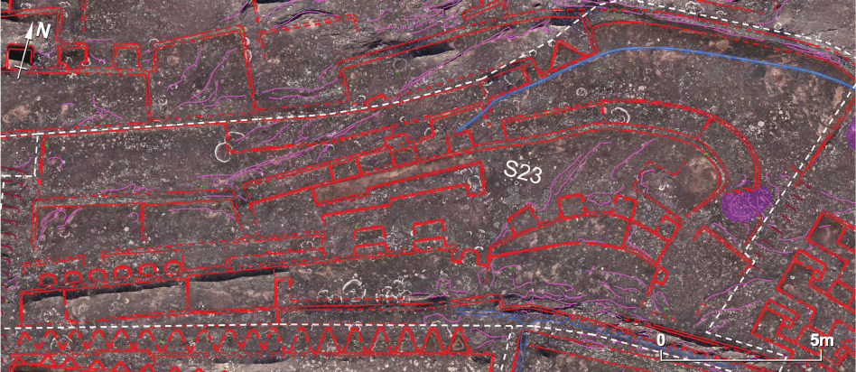
ElFuertedeSamaipatainthelightofnewresearch / ElFuertedeSamaipatawświetlenowychbadań 109
Sector S23
Sector S23 (Fig. 47) extends to the east of the steps that
separate it from sectors S07 and S09. It consists of several
smaller units – each of them of a dierent layout, so as
a whole, it cannot be treated as one coherent complex. The
single name of “sector S23” was given to all these units
only for ease of description.
A long terrace divided into ve platforms extends
along the southern border of this sector. A small channel
collects water at its base. On the back of this terrace, one
can distinguish four dierent units. The rst from the west
is a set of six semi-circular seats (roughly 30 × 50 cm in
size) embedded into the rear wall of the rst two plat-
forms. Their axial distances range between 79 and 81 cm,
and might t well with the Incan unit of measurement
sikya [13], [15]. Further to the east, two benches over 3 m
long and ca. 45 cm deep are placed on top of each other.
They are framed on both sides with roughly 1 m-long sec-
tions of rear wall without any decoration. The next unit
consists of two pairs of short benches (ca. 90 cm wide and
30 cm deep), again on top of one another. This sequence
of dierently arranged seats ends with an elliptical recess
framed with two buttresses projecting from the rear wall
of the terrace. This recess, which looks more like the low-
er part of a niche than a regular seat, is orientated in a dif-
ferent direction to the seats already described. Its line of
sight orientation points in the same direction as the seats
of sectors S15–S20 located further to the west.
The back wall of the remaining, eastern part of the low-
est terrace of sector S23 is curved and follows the natural
shape of the original rock surface at this part. As a con-
sequence, the line of sight axes of four roughly square
(ca. 60 × 60 cm) seats cut into the back wall intersect just
at the lower, southern border of the sector. We do not
know whether this had any signicance or if it was only
the result of natural conditions, but it bears a distant sim-
ilarity with the circular “Orchestra” from the western part
of sector S25 (Fig. 49).
Behind these four seats lies another curved platform.
Its backside is equipped with three curved benches with
the same orientation as the lower seats. The easternmost
bench disturbs the earlier, now completely indeciphera-
ble, remains of an oval petroglyph in bas-relief. Back to
the west, three rectangular seats are cut into the back of
the platform. On the western side, they are anked by yet
another bench. Between them and the two pairs of bench-
es below, there is long and narrow protrusion from the
surface of the platform. Its surface, as well as the surface
of the western end of this platform, is rough and diers
considerably from the relatively smooth and even face at
the eastern part. One of the possible interpretations as-
sumes that the work of shaping the platform was never
completed there. This, in turn, may imply that this part
of the sector dates back to either the arrival of the Inca or
the end of their occupation of the site. The orientation of
all the seats in this sector, consistent with the orientation
of the seats in sector S21, and in particular with the ori-
entation of the Chakana-like platform (sector S22) may
indicate the second of these two possibilities more likely.
Further to the west lie two platforms and a spacious
(ca. 2 × 6 m) terrace above them. At the opposite north-east-
ern corner of this sector, this terrace has its counterpart,
although of a much more irregular shape. A narrow water
channel that starts in the northern part of sector S26 passes
through it diagonally following a natural crack in the rock.
Sector S24
Little can be said about sector S24 (Fig. 48), which is
squeezed between the top of the rock (sectors C07 and
N10) and sectors S21 and S23 on the southern slope of
the rock. It consists of a series of irregular platforms and
terraces with no consistent layout; however, they all seem
oriented in the same direction – towards the same part of
the plaza located to the south of the rock.
The only noteworthy observation in this sector con-
cerns the relative chronology. Two terraces at the eastern
Fig. 47. Sector S23
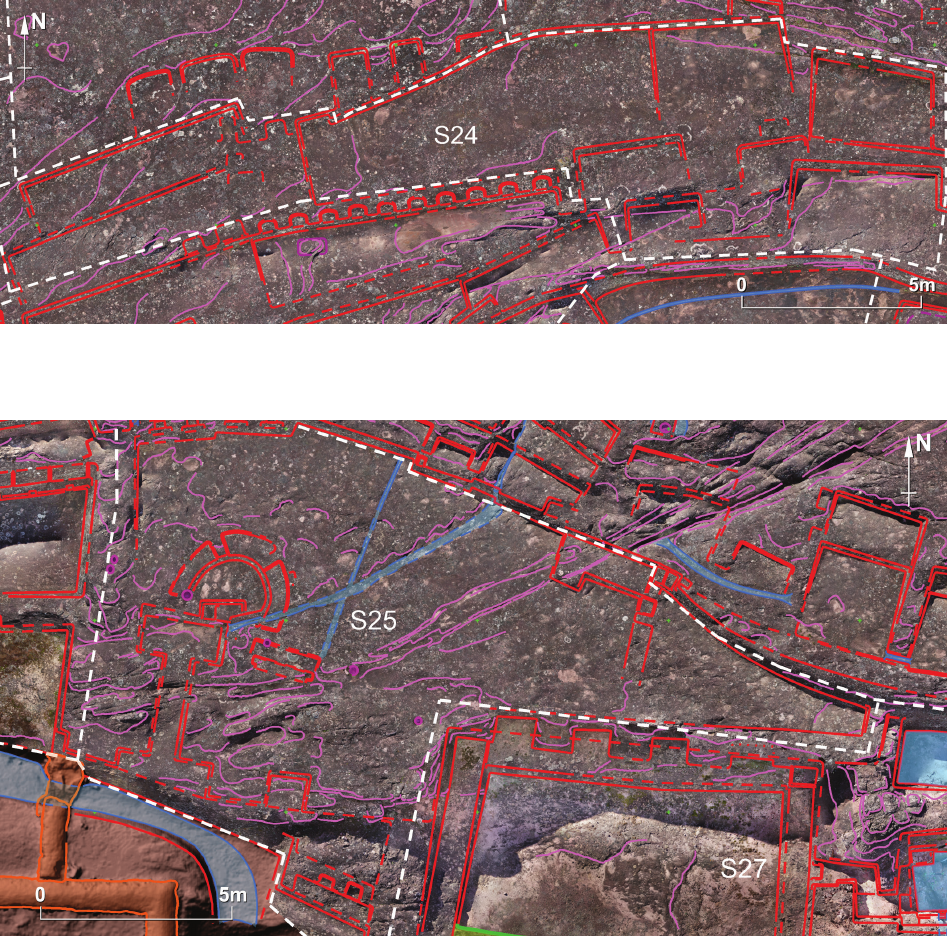
110 Jacek Kościuk, Giuseppe Orefici, Mariusz Ziółkowski, Anna Kubicka, Rosario Muñóz Risolazo
end of this sector seem to be of a later origin since they cut
into small platforms located to the west.
Sector S25
Sector S25 (Fig. 49) lies at the foot of the southern
slope of the rock. From the west, it borders an extreme-
ly eroded ramp climbing up the rock. Perhaps this is the
remains of earlier steps leading to sector S23, but at the
present state of preservation, no traces resembling steps
could be identied. From the north, sector S25 borders
sector S28.
The western end of the southern border of this sector
reaches the foot of the rock and ends with a nearly vertical
rock fault more than 1 m high. Below, but more to the
east, a small (ca. 2.35 × 0.35 m) terrace with two rectan-
gular, unequal recesses is set. Their line of sight orienta-
tion strongly resembles that of platforms and seats from
sector S26 located higher up the rock. Still further to the
east, the western part of neighbouring sector S27 cuts into
the at, hori zontal platform constituting the central part
of sector S25.
An interesting feature of the western part of sector S25
is a semi-circular “Orchestra” (roughly 2 m in diameter)
accompanied by three benches at the back. No other ar-
rangements of this kind have been found on Samaipata
rock. Small rectangular recesses cut into the front part of
the “Orchestra” do not t the design and might be a later
alteration.
In front of the “Orchestra” are highly eroded traces of
a shallow, double-T-shaped depression. It abruptly ends at
the southern part of the rock. It seems the vertical face of
the rock was cut down there when the U-shaped building
from the colonial period was erected in the eastern part of
sector S04.
Fig. 48. Sector S24
Fig. 49. Sector S25
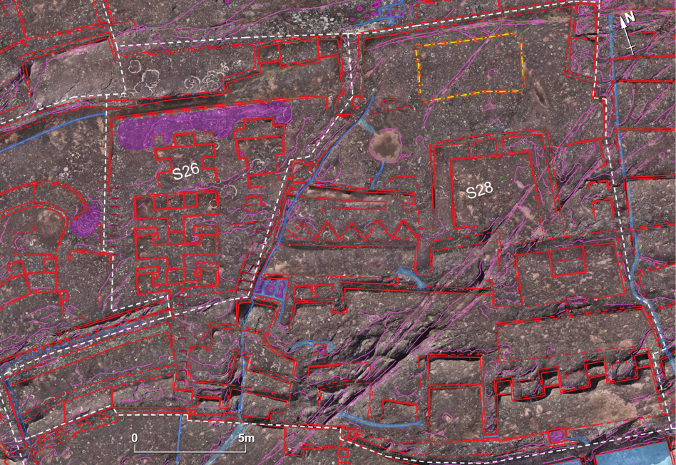
ElFuertedeSamaipatainthelightofnewresearch / ElFuertedeSamaipatawświetlenowychbadań 111
Fig. 50. Sectors S26 and S28
The western part of the central platform of sector S25 is
separated from the rest by a narrow water channel that leads
from the north down the rock. The part of it that lies behind
the “Orchestra” borders a steep rock scarp ca. 1.2 m high
in the north. Four double-recessed niches are equidistant-
ly placed on its western section. This decoration seems to
be an Incan addition to this evidently earlier sector.
Another channel that follows the natural crack in the
rock crosses the platform roughly at the centre. It brings
water from as far as the northern part of sector S28 and
terminates in front of the semi-circular “Orchestra”.
The remaining, eastern part of the central platform in
sector 25 does not bear any features except for a small
L-shaped terrace and very at, unclear traces of what might
once have been a small recess and a bench separating the
slightly raised eastern end of the platform.
Sectors S26 and 28
These two adjacent sectors (Fig. 50) are probably the
most interesting and intriguing parts of Samaipata rock.
Both lie to the north of sectors S25 and S27 and extend up
the rock until the big at area that constitutes sector S29.
The more westerly located sector S26 shows a very
consistent arrangement. Its main part is composed of three
successive platforms climbing to the north. Except for
small modications in the uppermost one, all of them have
an identical layout.
Their main part is a centrally located rectangular
(roughly 50 × 70 cm) seat anked by two raised buttresses
ca. 60 cm wide. Small benches are placed symmetrically
on both sides of these possibly ceremonial seats, except
on the third platform. The symmetrical layout of these
platforms is additionally emphasised by the coaxial steps
leading from the south.
Further to the north, another platform, this time of
a double-T shape, has been cut into the surface of the rock.
A rectangular, centrally located seat is placed at the back
of the platform. Faint traces of smaller seats accompany-
ing this seat on both sides are still noticeable. Directly to
the east, there might once have been a similar platform.
However, its rear side is arranged in a slightly dierent
manner, and the front side is very eroded. The rock sur-
face behind these two platforms is very irregular. It might
be that once a kind of east–west elongated petroglyph ex-
isted there. It must have been of an earlier origin since
both the platforms cut into it.
Behind this elongated petroglyph, there is a corridor,
0.45 m wide, ca. 1 m deep, and more than 5 m long, that
leads from sector S23 to yet another platform situated in
the north-eastern corner of the sector. Three rectangular
seats, the central one bigger and slightly raised, are set
against the back wall of this platform. Both the corridor
and the platform were apparently executed at the same
time as the upper terrace in sector S23.
Nearly ten separate units make up sector S28 (Fig. 50),
located adjacent from the east from sector S26. The rst
unit in the west consists of two terraces towering above
the western part of sector S25. The lowest one is divided
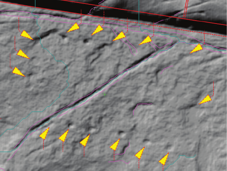
112 Jacek Kościuk, Giuseppe Orefici, Mariusz Ziółkowski, Anna Kubicka, Rosario Muñóz Risolazo
into three platforms, with the side ones being slightly el-
evated. An interesting feature is the rhomboid shape of
platforms, not seen in other sectors. The back wall of this
terrace is 0.7 m high. Even higher (ca. 1 m) is the back
wall of the next terrace adjacent from the north. Such sig-
nicant dierences in levels must have resulted in an im-
pressive cascade of water owing down the channel cut
along the side walls of both platforms.
The next unit of this sector has a very irregular arrange-
ment. Several small, dierently shaped platforms have
been cut to the east and west of the water channel running
from the north. Above the uppermost platform of this unit,
this water channel ows through a small (ca. 1 × 1.5 m)
rectangular reservoir at the bottom of which there are trac-
es of three, no longer identiable, petroglyphs. The whole
layout of this unit seems to be subordinated to the cult of
water, and this is further emphasised by the two rectangu-
lar ceremonial seats adjacent from the east of this unit. In
front of them, in the centre of a small (roughly 50 × 50 cm)
rectangular depression, traces of a rounded (ca. 23 cm in
diameter) oering hole are preserved. A small channel
branching from the area of the three petroglyphs might
have “fed” this oering hole. Below this, traces of some
other terraces, probably created earlier based on the state
of their preservation, are extant.
Two rectangular platforms located further to the east
are much better preserved. In the east, they border a much
bigger unit laid out over three terraces climbing the slope.
The lower one consists of a spacious (ca. 1.7 × 7.3 m) plat-
form with raised western and eastern borders isolating it
from neighbouring units. Four rectangular seats are placed
against the rear wall. Three buttresses, nearly 1.5 m wide,
separate them. Poorly preserved traces of much smaller
seats (ca. 50 × 60 cm) are visible on the top of each of the
buttresses. The front (southern) edge of this platform is
slightly raised so that the rainwater accumulates in a at
rectangular (ca. 60 × 80 cm) reservoir with indecipherable
traces of an oval petroglyph on its bottom. From there,
water passes a small meandering channel and runs down
from the edge of a nearly 2 m-high slope into the reservoir
located below. The level of the next, located further to the
north, terrace is raised for about 1 m. Three steps placed in
the centre of its back wall lead to another terrace that com
-
pletes the whole unit. There, in the centre of its 1.2 m-high
rear wall, two benches are set on top of one another. They
probably played the role of a ceremonial podium towering
over the terraces below.
Located above, the northern part of sector S28 narrows
gradually, squeezing between the neighbouring sectors
S26 and S31. Three further units constituting independ-
ent entities can be distinguished there. The westernmost
one starts with a terrace over 6 m long. The already men-
tioned reservoir with the three unclear petroglyphs on
the bottom attaches at the south-western corner of the
terrace. The rear wall of this terrace is nearly 1 m high
and ve triangular recesses decorate the top of it. Behind,
dicult to interpret traces of two narrow depressions ac-
companied by traces of rectangular recesses (or seats)
are extant. Possibly, these were sculpted earlier than the
triangular decorations. East of this terrace lies a unit of
a much consistent layout. A trapezoidal (ca. 3.0 × 3.7 m)
platform there opens to the south and is surrounded on
three sides by low benches. Two narrow buttresses in
the centre of the northern bench separate a more prom-
inent individual seat. Traces of rectangular recesses (or
possibly seats) to the east might be of an earlier origin,
so the whole unit was probably cut into an earlier (pre-
Incan?) phase.
The uppermost part of sector S28 is occupied by a at,
spacious (more than 5 × 10 m) terrace. Two small plat-
forms in its north-eastern corner facilitate movement up
to sector S29 located ca. 1 m above. Traces of at least
three at depressions in the western part of the terrace are
signs of an earlier decoration that was erased when this
terrace was arranged.
Other vestiges of earlier phases can be found on the cen-
tral part of this terrace. Fifteen round at holes (ca. 10 cm
in diameter), visible only on the hill-shaded mo nochroma-
tic 3D model, form a rectangular enclosure of 2.4 × 4.6 m
(Fig. 51). One possible interpretation assumes the exist-
ence of a small hut here with quincha type walls. Round
marks would then be remnants of the holes for the wood-
en posts of the wall. The hut, if it really existed in this
place, would have to have been from an earlier period
than the present form of this platform. Quincha wall post
holes are usually over 20 cm deep – in this case, levelling
the platform surface has led to almost completely eras-
ing them.
Sector S27
Sector S27 (Fig. 52) lies in the most southerly part of
Samaipata rock. It consists of two functionally distinct
parts that are connected by a special passage.
On the western side of sector S27 is a spacious court
separated from the south by a wall built of stone rubble.
A narrow entrance leads to it directly from the plaza at the
foot of the rock. The rear side of the court is bordered by
a steep edge of the rock and decorated with four niches.
The average width of niches and distances between them
is 105.2 cm, and again, this is a good approximation of
the unit of measurement used according to Kubicka [10]
Fig. 51. Round marks visible on the hill-shaded 3D model
of the central part of the upper terrace of sector S28
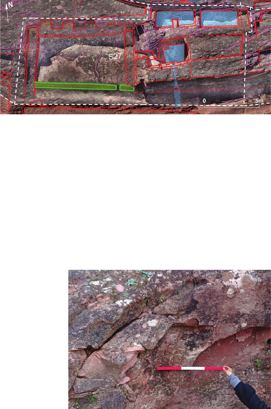
ElFuertedeSamaipatainthelightofnewresearch / ElFuertedeSamaipatawświetlenowychbadań 113
for buildings with the most prestigious function at Ma-
chu Picchu.
Spacious benches surround the court from the west,
north, and east. This courtyard was initially roofed, as is
clear from the presence of the front wall with the well
dened entrance and the side walls rising 2.25 m above
the stone oor inside.
The eastern part of sector S27 had a more utilitarian
function. A set of three deep reservoirs has been cut into
the rock there. The southernmost reservoir, 2 m deep,
collects water overowing from the other two reservoirs lo-
cated up the rock and has an outlet at a level close to its bot-
tom. Interestingly, a special Z-shaped entranceway connects
this reservoir with the court (building?) on the western side.
The side walls of the southernmost reservoir show ma-
ny steps and recesses perhaps facilitating climbing down
Fig. 52. Sector S27
Fig. 53. Andean Cross partially
preserved in a reservoir
in sector S27
(photo by G. Orefici, 25.06.2016)
for inspection and cleaning of the bottom part. On the
northern wall, Giuseppe Oreci found remains of what
might have once been an Andean Cross (Fig. 53). Be-
sides the already mentioned Chakana-like platform, it
is the only example of this symbol found on Samaipata
rock, and probably manifests the inuence of the Tiwan-
aku civilisation or was created during the period of Wari
culture expansion into the area of Bolivia, as can be at-
tested by similar examples found in the areas of Bolivia
and Brazil.
It is then evident that at least the upper part of the res-
ervoir in question had an earlier origin – however, dur-
ing Inca occupation of the site it was probably deepened.
The outlet on its bottom might also be of Incan origin and
probably provided water for the Incan building located di-
rectly to the south.

114 Jacek Kościuk, Giuseppe Orefici, Mariusz Ziółkowski, Anna Kubicka, Rosario Muñóz Risolazo
Sector S29
Sector S29 is located at the top of the rock (Fig. 54). Its
southern margin borders sectors S26 and S28. The north-
ern extent is limited by the eastern wing of an L-shaped
wall with double-recessed niches.
The central part of sector S29 was radically modied
in the Inca era, at the time when the L-shaped wall was
built. The archaeology of this wall was already examined
by the German mission led by Albert Meyers [12]. Ismael
Montero and Joanna Broda also studied it in 2006, determin-
ing that it functioned as an astronomical observatory [16].
On the southern edge of this sector, traces of a present-
ly indecipherable petroglyph can be seen. This petroglyph
is surrounded by narrow water channels and eight small,
irregularly distributed oering holes.
At the eastern border of sector S29, remains of what might
have once been a representation of a meandering snake exe-
cuted in bas-relief are extant. Its overall length of more than
11 m makes it the largest snakelike sculpture on the entire
Samaipata rock. The origin of this image, closely related to
the cult of water and fertility, might go back to the period
when the site was occupied by Chané-Arawak cultures
(ca. between 800 and 1450 AD). During Inca dominance, or
even earlier, the snake gure was severely modied with tri-
angular seats cut into both of its sides. The head of the snake
also completely disappeared, although this was partially
due to intentional erasing and partially to natural erosion.
Some modications were also introduced in the narrow
area between the snake and the eastern end of the L-shaped
wall. Two rectangular seats were cut in with two narrow
(ca. 45 cm wide) steps between them facilitating access
to the area above where several round oering holes are
irregularly distributed. In the present state of preservation,
only a few centimetres are left between the L-shaped wall
and the northernmost seat, making the latter completely
afunctional. Since the rectangular seats seem to have been
sculptured at the same time as the triangular ones, this
suggests that both alterations were executed before the
L-shaped wall was erected.
Sector S30
Sector S30 occupies the south-eastern edge of the rock
and borders sector S27 from the west and sectors S31 and
S32 from the north. A steep slope forms its southern border.
Two elongated terraces have been cut into this slope. Steps
leading from the north provide a secure entrance to the up-
permost terrace. However, there are no traces of any access
to the lower terrace located down the slope. It only had the
technical function of collecting rainwater owing down the
slope and channelling it o the rock. None of the terraces
show traces of any seats or decoration, which may be due
to the very poor state of preservation of this part of the rock.
Sectors S31 and S32
Sector S31 extends between sector S30 in the south and
S29 on the top of the rock (Fig. 55). Two long ights of
steps set ca. 12 m apart delimit its western and eastern
borders. Along the western edge of the sector runs a long
channel that drains rainwater from the top of the rock and
the terraces located below.
Fig. 54. Sector S29
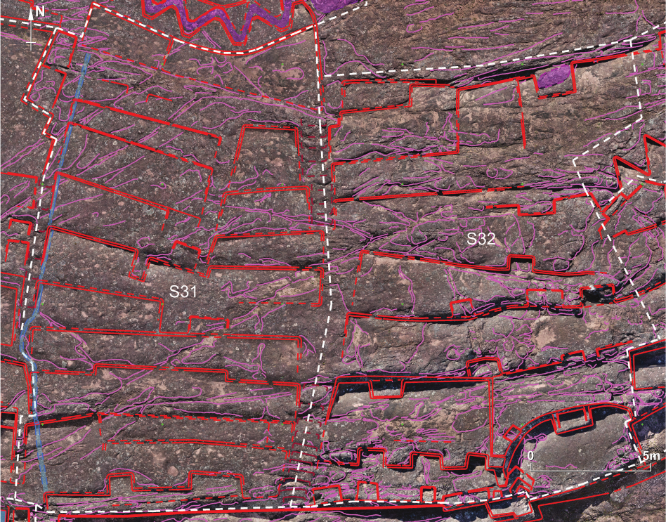
ElFuertedeSamaipatainthelightofnewresearch / ElFuertedeSamaipatawświetlenowychbadań 115
Six consecutive terraces extend across the entire width
of the sector in its lower part. Apart from the southern-
most one, where two rectangular recesses of unequal size
tower above the steep slope, the layout of the terraces
is simple.
The upper part of the sector is divided into two units
separated by a narrow, very eroded strip that might once
have been a ight of steps. Now, no traces of such are
visible. The slightly broader western unit consists of a se-
quence of four towering terraces. Again, their layout is
very simple and except for the rst platform (the lowest
one), no any additional features such as seats or recesses
are present. The eastern unit is composed of four simple
trape zoidal platforms of which the uppermost one is the
narrowest.
Located to the east, sector S32 shows a much more
complicated arrangement (Fig. 55). Two units constitute
its lowest, southern part. The western one consists of two
platforms. The front edge of the lowest one is decorated
with three unequal recesses. A more symmetrical layout
is shown on its rear side, where three recesses have also
been carved, but in a more orderly equidistant manner.
Two of them of an equal size (ca. 0.7 × 1.0 m), while the
last one is much smaller so as to avoid cutting into the
semi-circular unit located to the east. The upper terrace
of this unit is much deeper and extends for more than 3 m
in a north–south direction. A single trapezoidal bench
(or possibly seat) is asymmetrically placed against its
0.8 m-high rear wall.
The second, more easterly unit consists of a semi-cir-
cular platform nearly 6 m in diameter. At its apex, a cer-
emonial seat with raised shorter edges is attached to the
0.8 m high rear wall. There is a small (45
×
65 cm) recess
cut into the upper edge of this wall to the west of the seat.
A similar one probably also existed on the eastern, now
completely eroded side. The front part of this platform has
also already collapsed. Only at its western end are three
rhomboid recesses preserved. They form a diamond-like
pattern that is unusual for Samaipata.
Above these two units is a sequence of several terraces
that extend for the whole width of this sector. The rst two
show an orientation similar to the lower, westerly unit,
although they are probably of an earlier origin since the
last cuts into the central recess of the lowest of these two
terraces. Their much more eroded surface further conrms
this relative dating. The uppermost terraces of sector S32
are dierently orientated and are probably even older than
the middle ones. The surface of the rock is very weath-
er-beaten there, and it is dicult to determine the plan-
ning concept at this part of the rock.
Fig. 55. Sectors S31 and S32
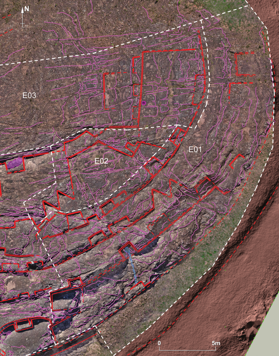
116 Jacek Kościuk, Giuseppe Orefici, Mariusz Ziółkowski, Anna Kubicka, Rosario Muñóz Risolazo
Eastern part of the rock
In this part of Samaipata rock, three separate sectors
can be distinguished: E01, E02 and E03 (Fig. 56). All of
them show traces of very advanced erosion; therefore, lit-
tle can be determined about their original layout. What
can still be seen today is a sequence of terraces along the
arched, eastern slope of the rock.
The only features that may attract more attention are
two sets of double, triangular recesses in sectors E01 and
E02. In sector E02, they ank a big trapezoidal terrace,
to which a smaller, also trapezoidal, platform attaches
Fig. 56. Sectors E01, E02, and E03
ElFuertedeSamaipatainthelightofnewresearch / ElFuertedeSamaipatawświetlenowychbadań 117
from the north. Similar triangular recesses are however
missing on the eastern side of the big trapezoidal terrace.
The other two triangular recesses are in the central part
of sector E01. They have been cut into the rear side of
the eastern end of the middle terrace, but a further contin-
uation of this kind of layout cannot be traced. The surface
of sector E03, as well as the northern part of sector E01,
is very fractured and battered due to harsh climatic con-
ditions at this part of the rock. The less compact structure
of the sandstone rock also contributes to this quickly pro-
gressing erosion.
The only anthropogenic traces preserved in this sector
are two terraces in its eastern part. They are both orien-
tated directly to the east. The more spacious (ca. 5.5 by
more than 7.0? m), lower one has a centrally placed re-
cess in its oblong front edge. The rear side also shows
a symmetrical layout – three small, rectangular benches
of roughly similar size (ca. 0.5
×
1.0 m) have been carved
there at equal intervals. Behind these, a much smaller
(ca. 2.6
×
3 m) platform completes the layout. It seems that
this unit could be from an earlier period than the neigh-
bouring trapezoidal platform from sector E02. Perhaps
two similarly oriented terraces with the same kind of lay-
out once existed in the northernmost part of sector E01.
However, only very faint traces of them have survived,
visible only under the right angle of oblique lighting
Summary and conclusions
Generally, chronological data for rock art are very lim-
ited, and few studies attempt to determine a chronological
sequence for this form of expression. Due to this, it is dif-
cult to obtain reliable data. However, in the last 30 years,
considerable progress has been made in dating some sites.
Studies about archaeological sites in the Cochabamba
Department [17], [18] and from the area of de la Serranía
San José in the Santa Cruz Department [19], particularly
that of Santa María Chica Cave, have shown that for some
kinds of rock engravings and paintings, absolute dating
can be provided.
The relative or absolute chronology of this class of
rock art can be, at least theoretically, established with the
following techniques and methods:
1. Superposition analysis that makes it possible in sev-
eral cases to establish which of the engravings is earlier or
later than others.
2. Stylistic and formal comparative analysis that al-
lows some of the representations to be associated with
ones from other, better dated sites.
3. Analysis of the technique of execution, taking into
account not only the type of rock art (e.g., rock painting,
relief) but also the technologies used to create them, for
example, in the case of reliefs, concave, convex, incised, or
dotted relief. Such analyses may allow particular images to
be linked with specic cultural circles of a known dating.
4. Some techniques for the absolute dating of engrav-
ings such as lichenometry or the analysis of the micro-ero-
sion of the petroglyph surface.
5. Dating of the archaeological contexts associated
with the rock. However, this method only points since
when human presence existed in the investigated area; it
does not determine when the engravings began to be made.
We will start with this last method. Ceramics from the
Formative Period (at least the end of the rst millenni-
um BC) have been found in the excavations carried out
near Samaipata rock [12, p. 79], particularly in the res-
idential area and in the lling of the terraces [20], [21,
p. 121]. However, for the moment, it is not possible to
attribute such an ancient dating to any of the petroglyphs
of the rock.
In terms of absolute dating (point 4 above), there was
some hope that analysing the micro-erosion of petroglyph
surfaces would be useful [22], [23]. Unfortunately, this
method is limited only to crystalline rocks, so at the pres-
ent stage of its development, it cannot be used for the sed-
imentary rock at Samaipata. Lichenometry cannot be used
for various reasons, either. The main one is that the rock
surface has been modied several times by dierent an-
thropic factors, making it practically impossible to deter-
mine places in which lichens began to grow immediately
after the execution of any particular petroglyph. Addition-
ally, the climatic conditions of Samaipata result in a dif-
ferent growth process of lichens compared to, for exam-
ple, North America or Easter Island, where lichenometry
was relatively successful. The third and nal reason is that
there is no calibration curve based on growth rate data for
local lichens at Samaipata [24].
Going back to the rst method, superposition analysis,
chronological dierentiation can be based on observa-
tions of rock shaping phases, marks of intentional recut-
ting, and characteristic formal features. Analysis of those
features makes it possible to create a tentative “relative
chronology” map of the engravings (Figs. 57 and 58). The
main distinction achieved in this map is between “earlier”
and “later” phases (A and B on Figs. 57 and 58). Only in
some cases was it possible to suggest particular features
as “possibly Incaic” (C on Figs. 57 and 58). It is, however,
important to mention that category “B” should not always
be considered as before the Incaic period. Sometimes the
carvings in this category may be modications made in
Inca times but without the typical stylistic features of this
period. From this point of view, one cannot add much more
to the ndings of previous researchers, who dieren tiated
two main stages in the cultural activities at the rock:
– pre-Incaic period, probably divided into dierent
cultural phases,
– Incaic period, of which, apart from the buildings on
top of the rock, the most outstanding feature is the cere-
monial “reorientation” towards the great plaza south of
the rock (see below).
Stylistic and formal comparative analysis, as well as
analysis of the technique of execution of particular en-
gravings (methods 2 and 3 above), bring other problems,
particularly with respect to the pre-Incaic phases of the
shaping of the rock. The diculty in absolute or even
relative dating of carvings at Samaipata rock also arises
from the universality of the occurrence of specic icono-
graphic motifs. Several rock art symbols are common
in the territory of South America, and they are related
to ancestral themes that characterise the Amazonian and
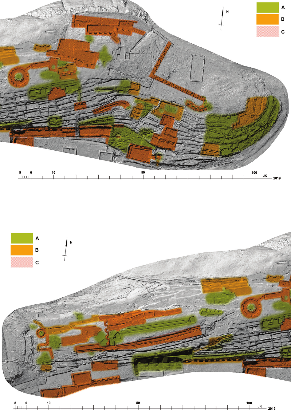
118 Jacek Kościuk, Giuseppe Orefici, Mariusz Ziółkowski, Anna Kubicka, Rosario Muñóz Risolazo
Fig. 57. Eastern part of the rock – relative chronology:
A – earlier;
B – later;
C – possibly Incaic
Fig. 58. Western part of the rock – relative chronology:
A – earlier;
B – later;
C – possibly Incaic
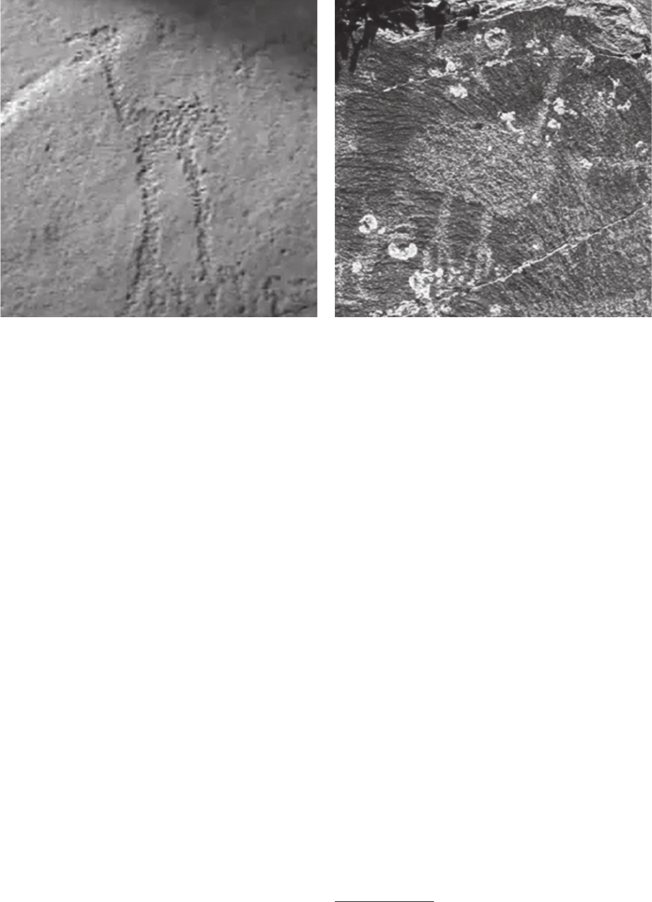
ElFuertedeSamaipatainthelightofnewresearch / ElFuertedeSamaipatawświetlenowychbadań 119
Andean area. For example, representations of serpents
and felines are typical over all the South American terri-
tory, and these iconographic motifs are the most common
expressions of the main divinities of the religious world.
Thus, for example, the meandering snake is found on
the site of the large El Buey rock shelter. Roy Querejazu
Lewis [17] identies the El Buey site as belonging to dif-
ferent moments in the development of several agro-pot-
tery periods and compares them to Yampará ceramics
(1100–1470 AD). However, interpreting the iconography
of the reliefs sculptured on Samaipata rock as belonging
exclusively to the Late Intermediate Period or Late Re-
gional Development (800/1000–1400 AD) seems to be
a bit extreme. There are several examples of reliefs with
serpentine elements, for example on stelae at the Khonkho
Wankane site in the Lake Titicaca Basin [25], which can
be dated back to the Late Formative Period (approximate-
ly 200 BC–500 AD), if not earlier, to the Middle Forma-
tive Period (ca. 800–200 BC).
In Eastern Bolivia, generally, examples of sculpted
rocks related to rituals of water worship and fertility are
most frequent in the vicinity of rivers and at the conu-
ence of them. They are often associated with round holes
serving as oering pits to be lled with rainwater or spe-
cial liquids. This strong association between petroglyphs
and oering holes is also present at Samaipata rock.
As already stated, the gural and geometrical petro-
glyphs found on Samaipata rock do not belong to a sin-
gle chronological moment. We can rather assume that
the sculpturing of these images had an intense dynamic
and that even though they all exist in the same place, the
importance of dierent symbols has varied throughout
time. Therefore, there were probably many more gural
representations sculptured on the rock surface from since
the time that it became a spiritual centre for the local
population. These were added, modied, or erased ac-
cording to the evolution of local beliefs and changes in
associated rites.
Among dierent zoomorphic petroglyphs, those of
snakes are particularly frequent and important. We found
them on the top of the rock as well as in the lower parts.
They are usually in the form of a meandering snake. The
only exception might have been the representation of
a coiled serpent, which, according to historical sources
[5], was located in the western part of the rock, just north
of the two depictions of felids. Today it is dicult to even
identify this spot exactly, let alone recognise the image.
It seems, however, that this petroglyph might have been
rather a representation of a meandering snake
14
, as repre-
sented by d’Orbigny on his drawing (Fig. 6).
Both the representations of felids and the now lost
coiled(?) serpent are coeval and can be possibly dated to
the Late Intermediate Period (ca. 1000–1400 AD). How-
ever, the neighbouring, nowadays completely indecipher-
able, image of a rhea can be of even earlier provenance
since as an exception, it was probably executed in sunk-re-
lief
15
. Known examples representing rheas might be petro-
glyph no. 2 from Tarija, Orozas (Fig. 59), or a pe troglyph
from Poopó, Oruro (Fig. 60). Generally, repre sentations
of rheas can be traced back to as early as the second mil-
lennium BC [27], [28].
On the other hand, all these petroglyphs belong to the
feline-snake-bird triad, which is the most representative
14
Cf. J. Kościuk, M. Ziółkowski, M. Pakowska, Formal and ico-
nographic analysis and interpretation of the most damaged petroglyphs,
in the same issue of “Architectus”.
15
Cf. J. Kościuk, M. Ziółkowski, M. Pakowska, Formal and ico-
nographic analysis and interpretation of the most damaged petroglyphs,
in the same issue of “Architectus”.
Fig. 60. Representation of a rhea (ñandú)
on a petroglyph from Poopó/Oruro
(photo by M. Strecker, March 2012, source: [26])
Fig. 59. Representation of a rhea (ñandú) on a petroglyph no. 2
from Tarija/Orozas (source: extract from YouTube movie,
https://www.youtube.com/watch?v=jXvhVrpvDB0)
120 Jacek Kościuk, Giuseppe Orefici, Mariusz Ziółkowski, Anna Kubicka, Rosario Muñóz Risolazo
for the religious world of the South American area and
for the eastern Bolivian jungle; therefore, despite possible
dierences in sculpturing technique, all of them may have
the same cultural provenance that however cannot be pre-
cisely dated. This type of iconography already existed at
least from the second millennium before our era, and can
be seen in petroglyphs from Argentina, Peru, and Bolivia
[29], [30].
All the gural petroglyphs found on Samaipata rock
are connected to the cult of water. The two felids in the
western part of the rock and the so-called Altar (“Choir
of
the Priests”) are even surrounded by circular water chan-
nels. For other petroglyphs, water channels pass beside or
through the petroglyphs (for example, the “Double Puma(?)”
or “Triple Snake”, both in the eastern part of the rock), or
rounded pits for liquid oerings are located nearby (the
“Big Snake”, “Snake-catching Animal”, or the lost rhea
petroglyphs). The eastern part of the rock is particularly
abundant with this kind of pit. They can be distinguished
from natural openings in the rock by the shape and charac-
ter of the inner surface, and in some cases by the presence
of channels that guide liquid into the holes. Possibly, they
formed part of rituals related to sunrise or water. Similar
circular holes, which were elements of water worship, can
also be seen in the Roca de Mairana [31]. Samaipata rock
also has another type of rounded hole meant for oering
deposits. These are found on the entire surface of the rock
and in particular on the southern and northern sides.
They are also many traces of now indecipherable cir-
cular petroglyphs. Typically, these are between 1.5 and
3 m big, but some of them have a diameter of more than
5 m. They are mostly located on the top of the rock and its
northern slope. As they were erased or even cut through
by later activities (sculpturing terraces, benches, or seats),
they are evidently of an earlier, pre-Incaic origin. The fact
that they bear not only traces of intentional erasing, but
they are generally much more eroded than the other exam-
ples, also suggests a much earlier origin.
The association of circular petroglyphs with earlier
phases of the sculpturing of Samaipata rock may lead to
a conclusion about preferences for circular shapes in ear-
lier periods. However, since there are other, non-circular,
petroglyphs attributed to earlier periods (for example, two
big meandering snakes into which zig-zag seats were cut
during later times), a circular shape cannot be considered
as the only decisive factor in chronological analysis.
The most emblematic gure on Samaipata rock is the
“Big Snake” – the long geometric petroglyph more than
30 m long that is interpreted as a representation of a rattle-
snake. Since generally, the edges of the rhomboid patterns
as well as of the two accompanying gutters are relatively
sharp, this petroglyph has probably not been exposed for
a long time to atmospheric and bio-erosion factors. There-
fore, the most probable dating is not very much earlier
than the Late Intermediate Period. During the Inca period,
this petroglyph lost or changed its symbolic and religious
signicance. A north–south oriented wall erected across
the top of the rock made the petroglyph inaccessible for
viewing from the only place from where it might have
been admired – from the slope of the hill rising to the west.
The earliest anthropogenic traces on Samaipata rock
are to be found on its eastern side. From there, access to
the top of the rock was also the most convenient. Possibly,
this was the oldest main route to the summit of the rock,
from where one could proceed further to the west or down
the southern slope. Several steps, often separating dier-
ent groups of terraces and platforms, facilitated move-
ment down the steep southern slope. Some of these were
modied over time due to the erosion aecting the struc-
tural integrity of the rock and changes in the function of
particular sectors. Modications were also made to other
features sculptured on the rock – oering pits, water res-
ervoirs, seats and benches, as well as many petroglyphs.
The triangular seats(?) that frequently appear on the
rock, often in long rows, are also worth attention. Al-
though this shape is untypical for Incan architecture,
some examples of triangular niches are known [14, p. 256,
Fig. 242]. However, generally, they were more likely to
have been made during earlier periods of Samaipata rock
shaping. This is also true for the triangular seats in the
“Choir of the Priests”.
One of the typical architectural forms on Samaipata
rock is niches. Some of these are double-recessed, trap-
ezoidal in shape, or show metrological similarities with
Incan architecture. None of these features, however, can
be considered as clearly indicating Incan origin. Such ar -
chitectural elements are also typical for the Tiwanaku cul-
ture; therefore, they are considered by us only as “possi-
bly Incan”.
The possible inuence of Tiwanaku culture on Samai-
pata carvings presents another problem. This inuence
may be seen in the architectural elements of the niches
as well as the traces of the Andean Cross found in Sec-
tor S27 and the Chakana-like platforms. On the one hand,
we have clear evidence of the inuence of Tiwanaku cul-
ture in the Cochabamba valley [32] – so approximately
halfway between Samaipata and Lake Titicaca. However,
there is generally a view that in Bolivia, there is no evi-
dence of the inuence of Tiwanaku culture on rock art.
In a UNESCO report about rock art in Bolivia, Matthias
Strecker even states […] An absence of rock art belonging
to the Tiwanaku culture has been noted by several inves-
tigators […] It is a curious fact that the only clear case of
Tiwanaku style rock art has been found outside Bolivia, in
northern Chile […] [33, p. 142].
The restructuring of the rock in Inca times
Summarising, we can state that over time, all the sculp-
tured forms, including petroglyphs, platforms, seats, nich-
es, terraces, and the steps connecting them, underwent
several modications due to the changing religious and
ceremonial needs. In most cases, it is not possible to deter-
mine the exact sequence of these changes and the specic,
pre-Incaic, periods in which they were made. There is no
doubt that generally the Inca expansion to new areas often
eliminated previous cultural elements, particularly when
they were deeply rooted in the social, political, and espe-
cially religious structure of the populations that had previ-
ously used the site. One other place of the many where this
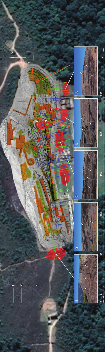
ElFuertedeSamaipatainthelightofnewresearch / ElFuertedeSamaipatawświetlenowychbadań 121
occurred is the Intihuatana in Pisaq, which was erected
in a place where much older symbols had been engraved
in the rock. Everything was removed from the previous
sacred element and replaced with the Intihuatana [34].
We must not forget a very specic factor: the Incas
erected a large ceremonial complex, with a great plaza and
kallanka, immediately south of the rock. As the main In-
can ceremonial activities were carried out in large squares,
usually located in the centre of settlements, presumably
this was also the case at Samaipata. An interesting analo-
gy to this particular relationship between the rock sculpted
with niches and benches and the adjacent plaza is found in
the Incan ceremonial centre of Coyoctor in the province of
Cañar in Ecuador [35].
The areas of worship and sacrices with ceremonial
seats or thrones, often of considerable dimensions and of-
ten several times remodelled, are generally oriented toward
the south. This southern edge of the rock, especially in its
eastern and central parts, was modied very drastically dur-
ing the Inca occupation of the site. The edge of the rock
was cut almost vertically, and several sets of niches were
placed there. Subsequent carving of platforms and terraces,
as well as the addition of new functions in some sectors,
caused remarkable transformations to be made to this part
of the rock. It seems that except for a long row of ten niches
in the central part of the southern edge of the rock, all other
niches might have been roofed. A similar arrangement
was also introduced at the northern edge of the rock – at
the “Temple of Five Niches”. It is, however, a possibility
that some of these modications were executed during the
Middle
Period or the Chané occupation of the site.
Since our knowledge about rites performed at the rock
is less than limited, we cannot reconstruct the “choreog-
raphy” of any ceremonies. Theoretically, two options are
possible. Certain rituals were performed on the rock, and
spectators gathered on the southern side, at the foot of the
rock. On the other hand, the presence of long benches that
could accommodate many people on the rock points to
another possibility. Seats and benches were indeed meant
for celebrants and their acolytes, but in addition to per-
forming certain rites, they watched processions and cere-
monies that took place at the foot of the rock. Most like-
ly, depending on the particular occasion, both scenarios
were possible.
Visibility analysis (analysis of the line of sight) can
shed some light on this. Benches, seats, and terraces, es-
pecially on the southern slope of the rock, mostly follow
the natural shape of the rock. However, drawing sightlines
perpendicular to the backside of the seat or bench leads to
some interesting observations (Fig. 61). Along the south-
ern side of the rock, within a range of 20–30 m, there are
four zones suitable for spectators where sightlines tend
to concentrate (Figs. 61A–D). However, the results of
analysis of the line of sight do not determine whether
the designated zones were intended for viewers observ-
ing the rites on the rock, or they were the route (or plac-
es) of the celebrations that were observed by privileged
spectators gathering on the benches and seats on the rock.
The following analyses ignore the vast area further south,
where a much larger audience could gather. Due to the
Fig. 61. Analysis of sightlines for benches and seats of earlier (1), later (2), possibly Incaic periods (3) and of unknown provenance (4). A–G – areas convenient for spectators (explained in the text)
122 Jacek Kościuk, Giuseppe Orefici, Mariusz Ziółkowski, Anna Kubicka, Rosario Muñóz Risolazo
References /Bibliografia
[1] d’Orbigny A., Viaje a la América Meridional, T. 4, Institut Français
d’Études Andines, Lima 2002, doi: 10.4000/books.ifea.6812, http://
books.openedition.org/ifea/6812 [accessed: 14.04.2019].
[2] Nordenskiöld E., Meine Reise in Bolivien 1908–1909, “Globus”
1910, Bd. 97, 213–219.
[3] Nordenskiöld E., The Guarani Invasion of the Inca Empire in the
Sixteenth Century: An Historical Indian Migration, “Geographical
Review” 1917, Vol. 4, No. 2, 103–121, https://www.jstor.org/stable/
pdf/207290.pdf [accessed: 18.02.2019].
[4] Nordenskiöld E., Indianer und Weisse in Nordost Bolivien, Strecker
und Schröder Verlag, Stuttgart 1922, https://www.yumpu.com/de/
document/read/20650859/indianer-und-weisse-in-nordostbolivien
[accessed: 24.05.2019].
[5] Pucher L., Ensayo sobre el arte prehistórico de Samaypata, “Revista
de la Universidad de San Francisco Xavier”, Universidad Mayor de
San Francisco Xavier Sucre, Sucre 1945, 17–61.
[6] Ponce Sanginés C., Tadeo Haenke y su viaje a Samaipata en 1795,
Centro de Investigaciones Arqueológicas, INAR, La Paz 1974.
considerable distance (75–150 m), anyone gathered there
could
probably only participate in ceremonies as a passive
viewer.
Area A has a visible preference for benches and seats of
a later period and gives a good view for at least three big
ceremonial seats of sector S32 (arrows on Fig. 61A). Area
B shows the concentration of most sightlines coming from
benches and seats of probably Incaic origin. In this case,
viewers gathered in front of the roofed(?) building located
in sector S27. Above, sets of seats and platforms in sectors
S26 and S28 towered over the southern slope of the hill
(arrows on Fig. 61B).
The sightlines of two areas located further to the west
(C and D) do not show any consistent chronological pref-
erences. Area C – where a U-shaped building was erected
in colonial times, gives direct access to the terraces on
the southern slope of the rock. There, on the border be-
tween sectors S09 and S10, starts a long stairway leading
up the hill (the middle arrow on Fig. 61C). A spacious
building with unnished niches on its back wall anked
its eastern side (the right arrow on Fig. 61C). To the east,
a set of platforms with several niches (some of them dou-
ble-recessed) adorned the rock face (the left arrow on
Fig. 61C).
Nearly all petroglyphs on Samaipata rock were sculp-
tured on at parts of the hill, either on its top or on arti-
cially created horizontal terraces and platforms; therefore,
they were visible only to those who were gathering di-
rectly on the rock. Exceptions, besides the already men-
tioned “Double Puma”, are the felines on the western
edge of the rock, and the petroglyph most emblematic for
Samaipata – the over 30 m-long representation of a rat-
tlesnake (“Big Snake”). All these petroglyphs were practi-
cally invisible to viewers assembling on the southern side
of the rock. The only place from which a bigger group of
spectators could view them was area E on the slope of the
hill rising to the west (Fig. 61E). This area has not been
excavated yet, but the terrain suggests that there could
have been several terraces falling to the east. This pos-
sibility, however, is severely limited by the construction
of the aforementioned transverse wall across the hill. It
practically wholly obscured the view to the “Big Snake”,
so only three petroglyphs depicting felines (three arrows
on Fig. 61E) remained visible to a bigger audience. These
alterations introduced apparently during the Inca occupa-
tion of the site may reect changes in ritual symbology
and associated rites.
In this context, one must also mention two specic
areas – F and G on Figure 61. In these areas, the arrange-
ment of seats and benches focuses on the area in close
vicinity. Both areas, rather poorly visible from the area
south of the hill, were probably meant for special, col-
lective rituals.
* * *
In summary of this attempt to address the problem of
the chronology of the rock art on Samaipata rock, we want
to emphasise that the objective of the entire project was
mainly technical – that is, to prepare high-precision 3D
documentation of this exceptional site.
Our primary goal was not to carry out a detailed com-
parative study, in a Pan-American context, on the symbol-
ic and chronological interpretation of the rock art. Look-
ing for possible analogies, we have tried to limit ourselves
to these territorially and culturally closest to Samaipata:
mostly, according to terminology from the Bolivian Rock
Art Research Society [36], from the Valles or Subandina
regions [31], [37]. The only exceptions were, in this case,
comparisons with similar monuments of Incan origin scat-
tered throughout the Tahuantinsuyu [37], [38].
More comprehensive analysis of chronological phases
of Samaipata rock shaping would require profound com-
parative studies on beliefs, symbology, and rituals of sev-
eral South American cultures that left their traces in this
region.
We must, however, remember that Samaipata, which
is the largest and most important site of its kind in South
America, due to its conformation, type of rock, and geo-
graphical position, was considered by its ancient inhabit-
ants as a very important sanctuary from the earliest times.
Its central geographical position with regards to commu-
nication ows between the jungle and the valleys deter-
mined its importance not only during the Middle Horizon
and Early Regional Development. Most probably the site
might have been considered as a cult place at least from
the Formative Period.
As mentioned, the detailed chronology of the site as
well as its cultural interpretation are outside of the scope
of this particular project. Its main aim was to document
the vanishing traces of this important site of rock art. The
observations we have presented above should be consid-
ered only as working hypotheses or directions for future
studies, but in no way as rmly established evidence. We
hope that our work will serve experts in more advanced
studies on the subject.
ElFuertedeSamaipatainthelightofnewresearch / ElFuertedeSamaipatawświetlenowychbadań 123
[7] Trimborn H., Der skulptierte Berg von Samaipata, “Archäologis-
che Studien in den Kordilleren Boliviens”, Bd. 3, “Baessler Archiv,
Beiträge zur Völkerkunde” 1967, NF 5, 130–169.
[8] Tadeo Haenke. Su obra en los Andes y la selva boliviana, G. Ovan-
do-Sanz (ed.), Los Amigos del Libro, Cochabamba 1974.
[9] El Fuerte de Samaipata: Estudios arqueológicos, A. Meyers,
I. Com bès (comp.), Biblioteca del Museo de Historia Universidad
Autó noma Gabriel René Moreno, Santa Cruz de la Sierra 2015.
[10] Kubicka A., Zastosowanie metody cosine quantogram do analizy
metrologicznej kompleksu Machu Picchu/Application of a cosine
quantogram method in metrological analysis of the Machu Pic-
chu settlement, Doctoral thesis submitted to the Faculty of Archi-
tecture, Wrocław University of Science and Technology, Wrocław
2019.
[11] Marulanda R., La roca esculpida del fuerte de Samaipata: Elemen-
tos de discusión para un enfoque interpretativo, [in:] A. Meyers,
I. Combès (comp.), El Fuerte de Samaipata. Estudios arqueológi-
cos, Biblioteca del Museo de Historia Universidad Autónoma Ga-
briel René Moreno, Santa Cruz de la Sierra 2015, 34–51.
[12] Meyers A., Los trabajos arqueológicos en “El Fuerte de Samaipa-
ta”, 1992–1996, [in:] A. Meyers, I. Combès (comp.), El Fuerte de
Samaipata. Estudios arqueológicos, Biblioteca del Museo de His-
toria Universidad Autónoma Gabriel René Moreno, Santa Cruz de
la Sierra 2015, 52–115.
[13] Rowe J.H., Inca culture at the time of the Spanish conquest, [in:]
J. Steward (ed.), Handbook of South American Indians, Vol. 2,
Smithsonian Institution, Washington, DC 1946.
[14] Gasparini G., Margolies L., Inca Architecture, Indiana University
Press, Bloomington–London 1984.
[15] Farrington I., Cusco. Urbanism an Archaeology in the Inka World,
University Press of Florida, Gainesville–Tallahasseee–Tampa–Boca
Raton–Pensacola–Orlando–Miami–Jacksonville–Ft.
Myers–Sara-
sota 2013.
[16] Alcázar De La Fuente R., El Sitio Ceremonial y Administrativo de
El Fuerte de Samaipata, “Boletín Tesape Arandu” 2015, Año 4,
Nº 21, 2–9, https://www.academia.edu/12331379/El_Sitio_Cere-
monial_y_Administrativo_de_El_Fuerte_de_samaipata [accessed:
10.07.2019].
[17] Querejazu Lewis R., El arte rupestre de “El Buey”, Departamento
de Cochabamba, Bolivia, “Boletín SIARB” 1989, Nº 3, 30–35.
[18] Querejazu Lewis R., Arte Rupestre en la Cuenca del Río Mizque,
[in:] M. Strecker, F. Huaranca (eds.), Arte Rupestre en los Andes de
Bolivia, SIARB, Sociedad de Investigación del Arte Rupestre de
Bolivia, La Paz 1986, 17–19.
[19] Kaier C., Tres sitios de pinturas rupestres en la parte occidental
de la Serranía San José, Departamento de Santa Cruz, Bolivia,
“Boletín SIARB” 1993, Nº 7, 59–95.
[20] Meyers A., Toward a Reconceptualisation of the Late Horizon
and the Inka Period: Perspectives from Cochasquí, Ecuador, and
Samaipata, Bolivia, [in:] R.L. Burger, C. Morris, R. Matos Men-
dieta (eds.), Variations in the Expression of Inka Power. A Sym-
posium at Dumbarton Oaks 18 and 19 October 1997, Dumbarton
Oaks Research Library and Collection, Washington, DC 2007,
223–254.
[21] Szykulski J., Investigaciones en los Sectores 1 y 2, [in:] A. Meyers,
I. Combès (comp.), El Fuerte de Samaipata. Estudios arqueológi-
cos, Biblioteca del Museo de Historia Universidad Autónoma Ga-
briel René Moreno, Santa Cruz de la Sierra 2015, 116–132.
[22] Bednarik R., Age Estimates for the Petroglyph Sequence of Inca
Huasi, Mizque, Bolivia, “Andean Past” 2000, Nº 6, 279–291.
[23] Bednarik R., A new method to date petroglyphs, “Archaeometry”
2007, Vol. 34, Iss. 2, 279–291.
[24] Benedict J.B., A Review of Lichenometric Dating and Its Applica-
tions to Archaeology, “American Antiquity” 2009, Vol. 74, No. 1,
143–172.
[25] Janusek J.W., Of Monoliths and Men: Human-Lithic Encounters
and the Production of an Animistic Ecology at Khonkho Wankane,
[in:] T.L. Bray (ed.), The Archaeology of Wak’as: Explorations of
the Sacred in the Pre-Columbian Andes, University Press of Colo-
rado, Boulder (Colorado) 2015, 335–365.
[26] Strecker M., Methfesse L., Rivera C., Taboada F., Lima P., Cami-
nos destruyen sitios de arte rupestre en Bolivia, “Boletín SIARB”
2012, Nº 26, 33–40.
[27] Recalde A., Colqui E., Las representaciones rupestres zoomorfas en
el centro de Argentina y la construcción de identidades (ca. 1500–
450 AP), “Boletín del Museo Chileno de Arte Precolombinom”
2019, Vol. 24, No. 1, https://scielo.conicyt.cl/scielo.php?script=s-
ci_arttext&pid=S0718-68942019000100083&lng=es&nrm=iso
[accessed: 21.05.2019].
[28] Zárate Bernardi M.S., Arte rupestre del Cerro Tunduqueral:
deniciónestilísticayperspectivascronoculturales, [in:] I Jorna-
das de Ciencia, Técnica y Posgrado de la Facultad de Filosofía
y Let ras, Universidad Nacional de Cuyo, Argentina, 2017, https://
www.academia.edu/36552429/ARTE_RUPESTRE_DEL_CER-
RO_TUNDUQUERAL_DEFINICI%C3%93N_ESTIL%C3%8D-
STICA_Y_PERSPECTIVAS_CRONOCULTURALES [accessed:
20.04.2019].
[29] Hostnig R., Los petroglifos de Boca Chaquimayo: reliquia arque-
ológica de la Amazonía puneña, Perú, 2009, http://www.rupes-
treweb.info/chaquimayo.html [accessed: 6.07.2019].
[30] Guroy J., El Arte Rupestre del Antiguo Perú, Institut Français
d’Études Andines, Lima 1999.
[31] Avilés Loaiza S.V., Piedras sagradas: Samaipata, Achira y Maira-
na: ¿Casos aislados o una tradición por descubrir en tierras bajas de
Bolivia?, 2015, http://www.rupestreweb.info/piedrassagradas.html
[accessed: 12.08.2019].
[32] Anderson K., TiwanakuInuenceon the CentralValley of Coch-
abamba, [in:] A. Vranich, Ch. Stanisch (eds.), Visions of Tiwan-
aku, The Cotsen Institute of Archaeology Press, [s. l.] 2013, 87–
112.
[33] Strecker M., Zone 4: West-north-west South America (north of the
Andes, Peru, Bolivia, Paraguay), 138–150, https://www.icomos.
org/studies/rockart-latinamerica/zone4.pdf [accessed: 16.07.2019].
[34] Angles Vargas V., Písac and the sacred valley of the Incas, Industrial
Gráca, Cusco 2001, 16–29.
[35] Siguencia Pinos R., Coyoctor, Casa de la Cultura Núcleo del Cañar,
Quito 2007.
[36] http://siarb-bolivia.org/regiones/ [accessed: 24.08.2019].
[37] Querejazu Lewis R., Arte Rupestre en el límite andino-amazónico,
“Boletín Ocial de la Asociación Peruana de Arte Rupestre” 2012,
Vol. 4, N
o
13–14, 349–360, https://issuu.com/apar/docs/boletina-
par4_13_14 [accessed: 3.08.2019].
[38] Van de Guchte M.J.D., Carving the World: Inca Monumental
Sculpture and Landscape, PhD dissertation, University of Illinois,
Urbana-Champaign 1990, https://www.scribd.com/document/
269527866/Van-de-Guchte-1990-Thesis-1 [accessed: 17.06.2019].
Acknowledgements /Podziękowania
The presented work is a part of the research sponsored by the grant giv-
entotheWrocławUniversityofScienceandTechnologybythePolish
National Science Centre (grant No. 2014/15/B/HS2/01108). Addition-
ally, the municipality of Samaipata, represented by Mayor Falvio Ló-
pes Escalera, contributed to this research by providing the accommo-
dationduring the eldworkin June andJuly 2016, aswell as inJuly
2017. The Ministry of Culture and Tourism of Bolivia kindly granted
all necessary permits (UDAM No. 014/2016; UDAM No. 060/2017).
The research was conducted in close cooperation with the Centre for
Pre-Columbian Studies of the University of Warsaw in Cusco. Spe-
cialists from many other universities and research centres also joined
the project.
124 Jacek Kościuk, Giuseppe Orefici, Mariusz Ziółkowski, Anna Kubicka, Rosario Muñóz Risolazo
Abstract
The study describes the results of the documentation of El Fuerte de Samaipata, a pre-Hispanic archaeological site in Bolivia on the UNESCO World
Heritage List. It summarizes the most recent observations of the carvings on the rock of Samaipata, which, due to progressing erosion, are slowly
vanishing. Thanks to modern documentation technologies, laser scanning, structural light scanning, digital photogrammetry, and advanced digital
analysis of images and 3D models of the site, all still visible traces of petroglyphs as well as “architectural” elements like terraces, platform, niches
and seats have been documented and described.
Key words: Samaipata, Bolivia, rock art, Andean archaeology, UNESCO World Heritage List
Streszczenie
W pracy opisano wyniki projektu dokumentującego El Fuerte de Samaipata, prehiszpańskie stanowisko archeologiczne w Boliwii wpisane na Listę
Światowego Dziedzictwa UNESCO. Artykuł podsumowuje najnowsze obserwacje dotyczące rytów naskalnych w Samaipata, które powoli zanikają
z powodu postępującej erozji. Dzięki nowoczesnym technologiom dokumentacji, skanowaniu laserowemu, skanowaniu światłem strukturalnym,
cyfrowej fotogrametrii oraz zaawansowanej cyfrowej analizie obrazów i modeli 3D terenu wszystkie nadal widoczne ślady petroglifów, a także
elementów „architektury” takich jak tarasy, platformy, nisze i siedziska zostały udokumentowane i opisane.
Słowa kluczowe: Samaipata, Boliwia, sztuka naskalna, archeologia andyjska, Lista Światowego Dziedzictwa UNESCO