2018
1(53)
DOI: 10.5277/arc180101
Jacek Kościuk*, Judyta Cichocka*
Zastosowanie algorytmów optymalizacyjnych
w badaniach nad wczesnośredniowieczną urbanistyką
na przykładzie Placu Targowego w Abû Mînâ (Egipt)
The use of optimization algorithms
in research on early medieval urban planning –
the case of the Market Place in Abû Mînâ (Egypt)
Wprowadzenie
Inspiracją do przeprowadzenia poniższej analizy była
lektura dwu niezwykle interesujących artykułów dotyczą-
cych urządzeń handlowych i dróg komunikacyjnych.
Pierwszy z tekstów, które zwróciły naszą uwagę, doty-
czył różnic w aranżacji frontonów sklepów (a szczegól-
nie szynków/barów) w Pompejach, Ostii i Rzymie [1].
Jego autor argumentuje niezwykle przekonująco, że róż-
nice te są wynikiem wprowadzenia ścisłych regulacji
budowlanych po wielkich pożarach Rzymu w 64, 69 i po
wtór nie w 80 r. n.e. Według autora, lokalizacje pompejań
skich szynków i dyspozycja ich frontów mają swe źródło
w swo istej, zdroworozsądkowej „optymalizacji” ze wzglę
du na atrakcyjność dla potencjalnych klientów. Wyraź
ne są preferencje do umieszczania szynków/barów przy
głów nych ulicach i/lub na ich skrzyżowaniach
1
, a do dat
kowo wśród tych zlokalizowanych na skrzyżowaniach
ponad połowa ma frontowe lady umieszczone w miejscu
optymalnym (od powiednio, prawa lub lewa strona frontu)
ze względu
na obserwację napływających potencjalnych
* Wydział Architektury Politechniki Wrocławskiej/Faculty of Ar
chi tecture, Wrocław University of Science and Technology.
1
85% spośród 160 pompejańskich szynków ma lokalizację przy
głównych ulicach, a jednocześnie na niemal dwu trzecich ze skrzy żo
wań głównych ulic odnajdujemy przynajmniej jeden szynk [1, s. 163].
Introduction
The following analysis was inspired by two especially
interesting articles regarding public amenities and pedes-
trian connections. The first of them regarded the differ-
ences between the design of shopfronts (in particular bars)
in Pompeii, Ostia, and Rome [1]. Its author argues quite
convincingly that the differences result from the introduc-
tion of strict building regulations after great fires of Rome
in 64, 69 and then in 80 CE. In the opinion of the author,
the location of Pompeian bars and the exposure of their
fronts was caused by a commonsense “optimization” due
to attractiveness for potential clients. It is evident that the
bars were preferably located by the main streets and/or at
their intersections
1
and additionally more than half of
those located at crossroads had their front counters most
conveniently placed (to the right or to the left of the front)
depending on the flow of potential clients
2
. Con sequently,
we have almost the same proportion of counters located
to the right and to the left of the front
3
. The situation chang
ed
radically after the introduction of building regulations
1
85% of 160 Pompeian bars were located by the main streets, and
at the same time at least one bar was located at almost two thirds of the
main street intersections [1, p. 163].
2
More than half of 72 bars were located at the main street intersec-
tions [1, p. 163].
3
Respectively 66 and 87 [1, p. 164].

4 Jacek Kościuk, Judyta Cichocka
klientów
2
. W konsekwencji mamy niemal taką samą pro-
porcję przykładów, kiedy lady umieszczano po prawej lub
lewej stronie frontu
3
. Sytuacja zmieniła się radykalnie po
wprowadzeniu regulacji budowlanych po pożarach Rzy
mu w drugiej połowie I w. n.e. Ścisłe przestrzeganie no
wych przepisów doprowadziło do daleko posuniętej uni
fi ka cji – zwłaszcza w odniesieniu do dyspozycji frontów.
Prak tycz nie wszystkie znane nam szynki w Ostii – zde
cydowa na większość z nich wzniesiona w czasie ekono-
micznej prosperity w II w. n.e. – mają lady umieszczone
po lewej stronie frontów, a drzwi po prawej
4
.
To interesujące studium uświadamia, jak istotnym ele-
mentem w kształtowaniu funkcjonalnej struktury miej-
skiej są naturalne, chciałoby się rzec, organiczne procesy
rozwoju i wzajemnej stymulacji. W tym przypadku decy-
dującą rolę odgrywały czynniki podaży, popytu i maksy-
malizacji zysku.
Drugim z tekstów, które nas zainspirowały, jest raport
opublikowany na łamach „Nature” [2]. Raport odwołuje
się do wcześniejszych prac tej samej grupy autorów [3],
[4] eksperymentujących z użyciem Physarum polycepha-
lum
5
jako medium symulującego kształtowanie się syste-
mu rzymskich dróg na Bałkanach pomiędzy I w. p.n.e.
a IV w. n.e. Autorzy zwracają jednocześnie uwagę na to,
że „właściwości komputacyjne” Physarum przy datne
w tego typu badaniach mogą być z powodzeniem symu-
lowane przez algorytmy genetyczne.
Trudno jest oczywiście porównywać wczesnośred
niowieczną Abû Mînâ z Pompejami u progu naszej ery.
Jeśli jednak brać pod uwagę cytowane już powyżej obser
wacje S. Ellisa [1] i aktualny stan naszej wiedzy doty
czącej wczesnośredniowiecznego osiedla w Abû Mînâ
[5], to wspólnym elementem mogą być właśnie organicz
ne procesy kształtujące elementy ich struktury funkcjo-
nalnej. Oczywiste, rzucające się w oczy różnice to sposób
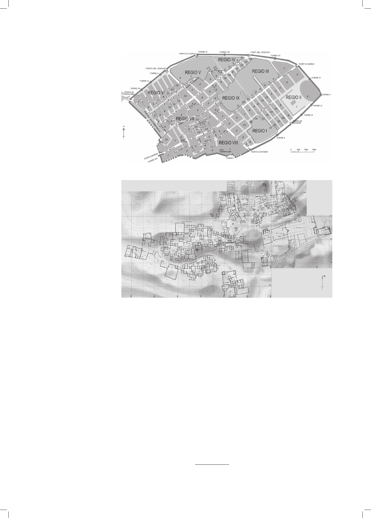
rozplanowania. Dziewięć funkcjonalnych stref Pom pei
charakteryzuje się regularną siatką ulic, która bez wąt
pienia jest wynikiem świadomych decyzji planistycznych
(il. 1).
W przypadku wczesnośredniowiecznego osiedla w Abû
Mînâ (il. 2) mamy do czynienia z nieregularną siatką ulic,
która jest efektem organicznego rozwoju niekontrolowa-
nego przez żadne zabiegi planistyczne [5, s. 86–88]. Ob
ser wacje te idą w parze z naszym ogólnym poglądem na
ur banistykę wczesnego średniowiecza we wschodniej częś
ci basenu Morza Śródziemnego. Jedną z powszechnie uzna
wanych cech ewolucji miast i osiedli tego okresu jest brak
jakichkolwiek śladów planowania w skali urbanistycznej,
a ich rozwój przestrzenny oparty był jedynie na natural-
nych zasadach „organicznego” wzrostu. Ch. Bou ras [6]
twierdzi nawet, że nie znajdziemy żadnego przykładu śla-
dów planowania w skali całego miasta. Biorąc pod uwagę
2
Ponad połowa z 72 szynków zlokalizowanych na skrzyżowa-
niach głównych ulic [1, s. 163].
3
Odpowiednio, 66 i 87 [1, s. 164].
4
Niemal 93% [1, s. 165].
5
Gatunek śluzowca, który choć nie jest bezpośrednio spokrewnio-
ny ani z roślinami, ani ze zwierzętami czy grzybami, ma niektóre cechy
przypominające je wszystkie.
after great fires of Rome in the second half of the 1
st
cen-
tury CE. The strict observance of the new re gulations
resulted in a farreaching unification – especially in regard
to the orientation of fronts. Practically all known bars in
Ostia – a great majority of them were built during the eco
no mic prosperity in the 2
nd
century CE – had their counters
placed to the left of the front and the doors to the right
4
.
This interesting study demonstrates the significance of
the natural or even organic processes of growth and mutu-
al stimulation in the shaping of the functional urban struc-
ture. In this case the crucial role was played by the factors
regarding supply, demand, and profitability.
The other article which was our inspiration is the report
published in “Nature” [2]. The report refers to an earlier
study by the same group of authors [3], [4] experimenting
with the use of Physarum polycephalum
5
as a medium
simulating the development of the system of Roman roads
in the Balkans between the 1
st
century BCE and the
4
th
century CE. The authors at the same time note that the
“computation features” of Physarum useful in this kind of
study can be successfully simulated by genetic algorithms.
Obviously it is difficult to compare early medieval Abû
Mînâ to Pompeii at the beginning of our era. If, however,
the observations by S. Ellis which have already been
quoted above [1] and our current knowledge regarding the
early medieval settlement in Abû Mînâ [5] are taken into
consideration, then the very organic processes shaping the
elements of their functional structure could be their com-
mon element. The obvious and evident differences include
their layout. The nine functional parts of Pompeii with
characteristic regular street network undoubtedly result
from rational planning decisions (Fig. 1).
The early medieval settlement in Abû Mînâ (Fig. 2)
had an irregular network of streets which was an effect of
organic growth not controlled by any urban planning [5,
pp. 86–88]. These observations are consistent with our
general opinion on early medieval urban planning in the
eastern part of the Mediterranean Sea. One of the univer-
sally recognized features of the evolution of the cities and
settlements in those times is the lack of any features of
urban planning and their space development was based
only on the natural principles of “organic” growth. In fact,
Ch. Bouras [6] claims that it is impossible to find any
traces of urban planning covering the entire city. Taking
into account the whole historical context and especially
the fact that Egypt severed the direct, cultural connection
with Byzantium in the middle of the 7
th
century, such
a claim can be even more relevant in reference to the
early medieval settlement in Abû Mînâ.
The lack of traces of any urban planning and the evi-
dent principles of organic growth regard also the network
of connections which anyway cannot be considered streets
in the strict sense – they are rather free, undeveloped
spaces used for connection purposes and they cannot be
compared to the network of Roman streets in the Balkans.
The principles of organic growth being the key factor in
4
Almost 93% [1, p. 165].
5
A species of a slime mold which, although it is not related to plants,
animals or fungi, demonstrates some features of all three of those groups.
Zastosowanie algorytmów optymalizacyjnych/The use of optimization algorithms 5
cały kontekst historyczny, a przede wszystkim zerwanie
przez Egipt bezpośredniej kulturowej łączności z Bi zan
cjum od połowy VII w., takie stwierdzenie może być tym
bardziej stosowne w od niesieniu do wczesnośredniowiecz
nego osiedla w Abû Mînâ.
Brak śladów planowania, a jednocześnie wyraźnie wi
doczne zasady organicznego rozwoju dotyczą także roz
-
planowania ciągów komunikacyjnych, które trudno zresz-
tą nazwać ulicami w ścisłym znaczeniu tego słowa – są to
raczej wolne, niezabudowane przestrzenie służące wła-
śnie celom komunikacji i ponownie trudno je porówny-
wać z siecią rzymskich dróg na Bałkanach. Zasady orga-
nicznego rozwoju jako głównego czynnika kształtującego
wczesnośredniowieczne osiedle odnajdujemy także ana
lizując rozmieszczenie poszczególnych funkcji, a w szcze-
gólności Placu Targowego (il. 3).
Reasumując, przytoczone powyżej badania nasunęły
nam pomysł zastosowania algorytmów genetycznych do
ana lizy usytuowania Placu Targowego w Abû Mînâ właś
nie jako efek tu or ganicznego rozwoju będącego, w na
szym
prze ko naniu, głównym czynnikiem kształ to wa nia
i roz wo ju osiedla. Stanowi to jednocześnie właściwy przed
miot prezentowanego tutaj studium.
the shaping the early medieval settlement can be seen also
when analyzing the location of individual public ameni-
ties and especially the Market Place (Fig. 3).
Summing up, the studies mentioned above inspired us
to apply the genetic algorithms to analyze the location of
the Market Place in Abû Mînâ as a result of organic
growth being in our opinion the key factor in the develop-
ment of the settlement and this is the subject of this study.
Subject of research
The early medieval settlement which developed since
the middle of the 9
th
century until the end of the 11
th
cen-
tury in the southern part of old, late ancient city took the form
of an elongated east–west orientated oval (ca 250
×
380 m)
of
the area of about 4.67 ha
6
. Two elements are evident in its
structure (Fig. 2). The southeast part (ecclesiastical centre)
including rebuilt Martyr Church, Ba ptistery and ruins of so
called Great Basilica. It is bordered in the north by a part
of the settlement surrounded by an outside wall which was
6
About 11% of the area of late ancient Abû Mînâ from the turn of
the 6
th
and 7
th
centuries.
Il. 1. Pompeje (źródło: https://
commons.wikimedia.org/wiki/
File:Eschebach_% C3%9
Cbersicht_Pompeji_150dpi.png
[data dostępu: 14.08.2017])
Fig. 1. Pompeii (source: https://
commons.wikimedia.org/wiki/
File:Eschebach_% C3%9
Cbersicht_Pompeji_150dpi.png
[accessed: 14.08.2017])
Il. 2. Wczesnośredniowieczne
osiedle w Abû Mînâ
(oprac. J. Kościuk)
Fig. 2. Early medieval settlement
in Abû Mînâ
(drawn by J. Kościuk)
6 Jacek Kościuk, Judyta Cichocka
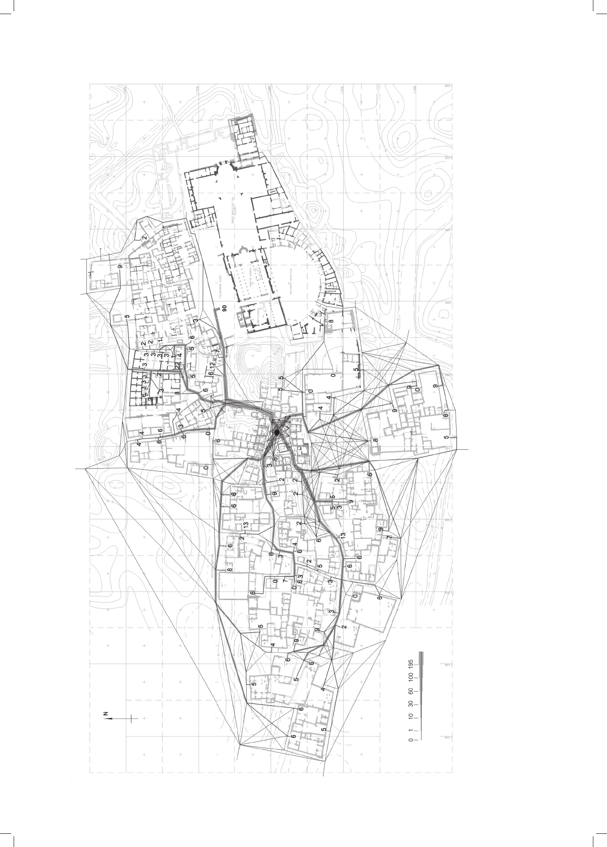
Przedmiot badań
Wczesnośredniowieczne osiedle, które rozwijało się od
po
łowy IX do końca XI w. w południowej części dawnego,
póź noantycznego miasta, przybrało formę mocno wy dłu żo
nego w kierunku wschód–zachód owalu (ca 250 × 380 m)
i zajęło powierzchnię około 4,67 ha
6
. W je go strukturze
(il. 2) daje się wyraźnie wydzielić dwa ele men ty. Część
południowowschodnią zajmuje ze spół sa kralny składa
jący się z przebudowanego Kościoła Gro bowego, Bap ty s-
terium i ruin tzw. Wielkiej Bazyliki. Od pół nocy przylega
do niego otoczona zewnętrznym murem część przezna
czo na, jak przypuszczamy, dla kleru i służ by kościelnej
[5, s. 72]. Na zachód od zespołu sakralnego leży świecki
rejon osiedla.
Pomiędzy eklezjastyczną (wschodnią) a świecką (za
chod nią) częścią osiedla położony jest niewielki plac (ca
20 × 28 m), w którego wszystkich pierzejach zlokalizowa-
no skle py i warsztaty. Jest to właśnie Plac Targowy wczes
n o
śred niowiecznej Abû Mînâ [7]. W bezpośrednim są
siedztwie zidentyfikowano także wiele innych budynków
handlowych – w sumie odkryto 31 sklepów i warsztatów,
5 piekarni i 1 młyn. Ten ostatni położony jest w cen trum Pla-
cu Targowego.
Plac Targowy w Abû Mînâ – zespół sklepów i warsz-
tatów zlokalizowanych w pierzejach niemal kwadratowe-
go placu – to wyjątek dla tego regionu i tej epoki [8]
7
.
Uwagę zwraca także nadreprezentacja sklepów i warszta-
6
Około 11% powierzchni późnoantycznej Abû Mînâ z przełomu
VI i VII w.
7
Syntetyczne ujęcie „ulic i placów handlowych” tego okresu znaj-
dzie Czytelnik w: [8, s. 107–120].
supposedly assigned for clergy and church staff [5, p. 72].
The main, secular part of the settlement is lo cated to the
west of the ecclesiastical compound.
Between the eastern and secular (western) part of the
settlement, there is a small square (ca 20 × 28 m) with shops
and workshops located on all of its sides. This is the very
Mar ket Place of the early medieval settlement [7]. Many of
other public buildings – in total 31 shops and work
shops,
5 bakeries and 1 mill – have been identified in its imme diate
neighborhood. That last structure is located in the cen ter of
the Market Place.
The Market Place in Abû Mînâ – a complex of shops
and workshops located on the sides of almost a rectangu-
lar square is exceptional for this region and those times
[8]
7
. What should be noted is the obviously excessive
number of shops and workshops
8
in relationship to the
number of local population with about 205 dwellings,
including 112 in the western part of the settlement. Ano
ther important aspect is the location of the Market Place
– inside of the settlement and conveniently located
between the ecclesiastical compound in the east and the
secular settlement in the western part of Abû Mînâ.
What factors then could have influenced such a con-
centration of public amenities in this very place? It should
be kept in mind that in the 9
th
century Abû Mînâ did not
serve the function of a local center
9
. What could be also
7
A synthetic description of the commercial streets and squares at
those times can be found in: [8, pp. 107–120].
8
In total 42 buildings, including 3 pottery kilns and 2 lime kilns in
the east part of the settlement.
9
No settlements active between the middle of the 9
th
and the be
ginning of the 12
th
were found within the area of over 15 km from Abû
Mînâ [5, p. 150].
Il. 3. Plac Targowy w Abû Mînâ
(oprac. J. Kościuk)
Fig. 3. Market Place in Abû Mînâ
(drawn by J. Kościuk)

Zastosowanie algorytmów optymalizacyjnych/The use of optimization algorithms 7
tów
8
w stosunku do wielkości lokalnej populacji składającej
się z około 205 gospodarstw domowych, w tym 112 w za
chodniej części osiedla. Kolejnym wartym rozpatrzenia
aspektem jest położenie Placu Targowego – wewnątrz osady
i dobrze wyważone pomiędzy eklezjastycznym zespołem na
wschodzie i świecką osadą w zachodniej części Abû Mînâ.
Jakie więc czynniki mogły wpłynąć na taką koncentrację
urządzeń handlowych w tym właśnie miejscu? Należy
pamiętać, iż IXwieczna Abû Mînâ nie pełniła funkcji lokal-
nego centrum
9
. Pod uwagę brać także można przebiegające
w pobliżu szlaki karawan, ale w tym przypadku, zgodnie
z tradycją charakterystyczną dla tego regionu, plac targowy
powinien być zlokalizowany na skraju osady, a nie w jej
centrum. W sumie, analizując położenie Placu Targowego
wczesnośredniowiecznego osiedla w Abû Mînâ, można
dojść do wniosku, że pod względem dostępności komuni
kacyjnej podporządkowane ono było „klienteli” lokalnej.
Hipotezy badawcze, dane wyjściowe analiz
i ich ograniczenia
Można więc przyjąć, że dyskutowana lokalizacja tar-
gowiska rządziła się mimo wszystko jakimiś racjonal
nymi przesłankami. Wspomniany już ewidentny brak śla-
dów planowania w skali urbanistycznej wskazuje na
or ganiczne procesy rozwoju i wzajemnej stymula cji, gdzie
– podobnie jak w omawianym na wstępie przypadku
Pom pejów – decydującą rolę odgrywały czyn ni ki podaży,
popytu i maksymalizacji zysku. Oczywiście, cały układ
(zabudowania mieszkalne i położone wśród nich sklepy
i warsztaty) musi być rozpatrywany dynamicznie. Jeśli
pierwsze sklepy pojawiły się w miejscu zapewnia jącym
optymalny dostęp dla ówczesnych mieszkańców, to za
pewne i dla nowo powstających domostw dostępność (blis
kość) Placu Targowego nie była bez znacze nia. Takie nowo
powstające domostwa, położone dogod nie względem za
lążków Placu Targowego akcelerowały z kolei proces kon
centracji sklepów i warsztatów w tym rejonie.
Jeśli przyjąć takie założenia, to Plac Targowy wcze-
snośredniowiecznego osiedla w Abû Mînâ powinien zna-
leźć się w miejscu najbardziej dogodnym dla lokalnej
społeczności – innymi słowy, w miejscu, które jest najła-
twiej dostępne dla ogółu klienteli. W tym momencie poja-
wia się naturalnie pytanie o strukturę takiej klienteli.
Postawimy tutaj trzy robocze hipotezy.
HIPOTEZA I
Plac Targowy w równej mierze obsługiwał wschodnią,
eklezjastyczną część osiedla, i zachodnią – świecką.
HIPOTEZA II
Plac Targowy służył wyłącznie mieszkańcom zachod-
niej, świeckiej części osiedla
10
.
8
W sumie 42 budynki, wliczając także 3 piece garncarskie i 2 wa
-
pienniki we wschodniej części osiedla.
9
W promieniu ponad 15 km od Abû Mînâ nie stwierdzono istnie-
nia żadnych osad funkcjonujących pomiędzy połową IX a początkiem
XII w. [5, s. 150].
10
Jest bardzo wątpliwe, aby kler i służba kościelna korzystały na
co dzień ze sklepów i warsztatów skupionych wokół Placu Targowego.
Kościół prowadził w tym czasie stosunkowo samodzielną działalność
gospodarczą, tylko częściowo przenikającą się z „rynkiem świeckim”.
taken into consideration are the routes used by caravans
going nearby. However, according to the tradition char-
acteristic of this region, the Market Place should be
located at the border of the settlement and not in its
center. Summing up, when analyzing the location of the
Market Place of the early medieval settlement in Abû
Mînâ, it could be concluded on the basis of its accessi-
bility that it was designed for the benefit of the local
“clientele”.
Research hypotheses, input data for analyses
and their limitations
It can be then assumed that the location of the Market
Place in question was governed after all by some rational
assumptions. The already mentioned evident lack of trac-
es of urban planning indicates organic processes of growth
and mutual stimulation where – similarly to Pompeii men
tioned at the beginning – the decisive role was played by
the factors connected with the supply and demand as well
as profit maximization. Obviously, the whole layout (res-
idential buildings as well as the shops and workshops lo
cated be tween them) must be considered dynamically. If
the first shops were established in the place providing the
optimum access for the residents, then the accessibility
(proximity) of the Market Place was surely also important
for new dwellings. Such newly built dwellings located
conveniently next to what later turned into the Market
Place accelerated the process of concentration of shops
and workshops in this area.
If such assumptions are made, then the Market Place
of the early medieval settlement in Abû Mînâ should have
been located in the most convenient place for the local
community – in other words in a place which is the easiest
accessible for the whole clientele. A question emerges
then here concerning the structure of such a clientele.
The following are our three working hypotheses.
HYPOTHESIS I
The Market Place served equally the eastern, ecclesi-
astical and the western, secular part of the settlement.
HYPOTHESIS II
The Market Place served exclusively the residents of
the western, secular part of the settlement
10
.
HYPOTHESIS III
The Market Place served the residents of the western,
secular part of the settlement and some unspecified group
of pilgrims who still visited the sacred center around the
tomb of St Menas.
The point of reference to verify those three hypotheses
is the number of residents of individual parts of the settle-
ment, including the size of individual dwellings [5,
pp. 131–135]
11
. The hypothetical number of residents of
10
It is highly doubtful that clergy and church staff used the shops
and workshops located around the Market Place daily. The church con-
ducted relatively independent commercial operations at that time, only
with tenuous connections with the “secular market”.
11
Table 15 presented in [5] shows the reconstructed number of
residents for individual buildings in the western part of the settlement
and tables 16 and 17 in its eastern part.

8 Jacek Kościuk, Judyta Cichocka
HIPOTEZA III
Plac Targowy służył mieszkańcom zachodniej, świec-
kiej części osiedla i bliżej nieokreślonej grupie pielgrzy-
mów, którzy nadal odwiedzali centrum sakralne wokół
grobu św. Menasa.
Punktem wyjścia pozwalającym na weryfikację tych
trzech hipotez jest liczba mieszkańców w poszczególnych
częściach osiedla z uwzględnieniem liczby osób zamiesz-
kujących poszczególne domostwa [5, s. 131–135]
11
. Dla
wschodniej, eklezjastycznej części osiedla hipotetycz-
na liczba mieszkańców to 265 osób, dla części zachod-
niej, świeckiej – 452 osoby. W naszej analizie liczba
mieszkańców w poszczególnych domostwach będzie sta
nowi ła wagę, z jaką mogły one ciążyć w kierunku naj do
godniejsze go miejsca, gdzie mogły lokalizować się skle
py i warsztaty.
Kolejnym elementem symulacji będzie plan zabudowy
wczesnośredniowiecznego osiedla z naniesioną siatką
wszystkich możliwych połączeń wzdłuż istniejącej sieci
ulic oraz liczbą mieszkańców w poszczególnych domo-
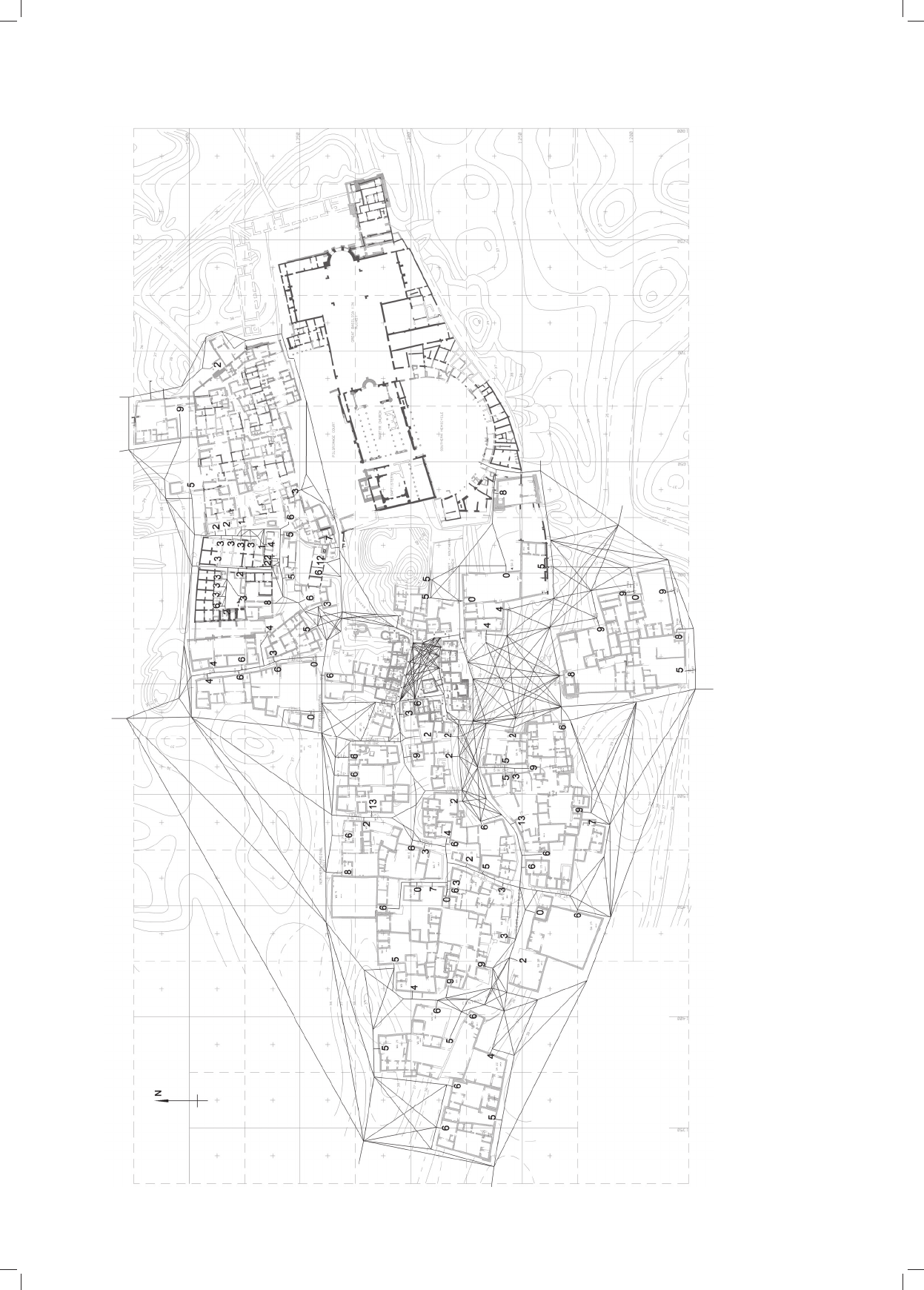
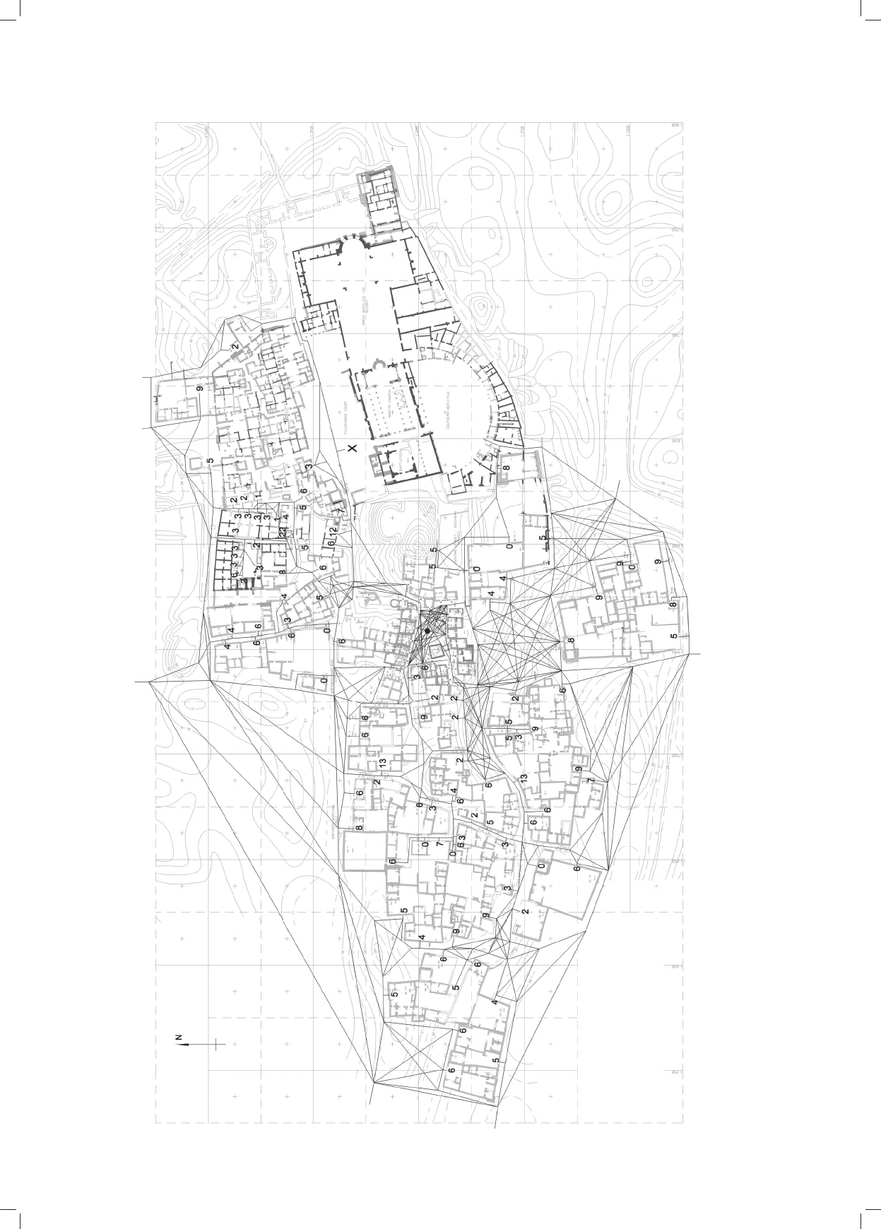
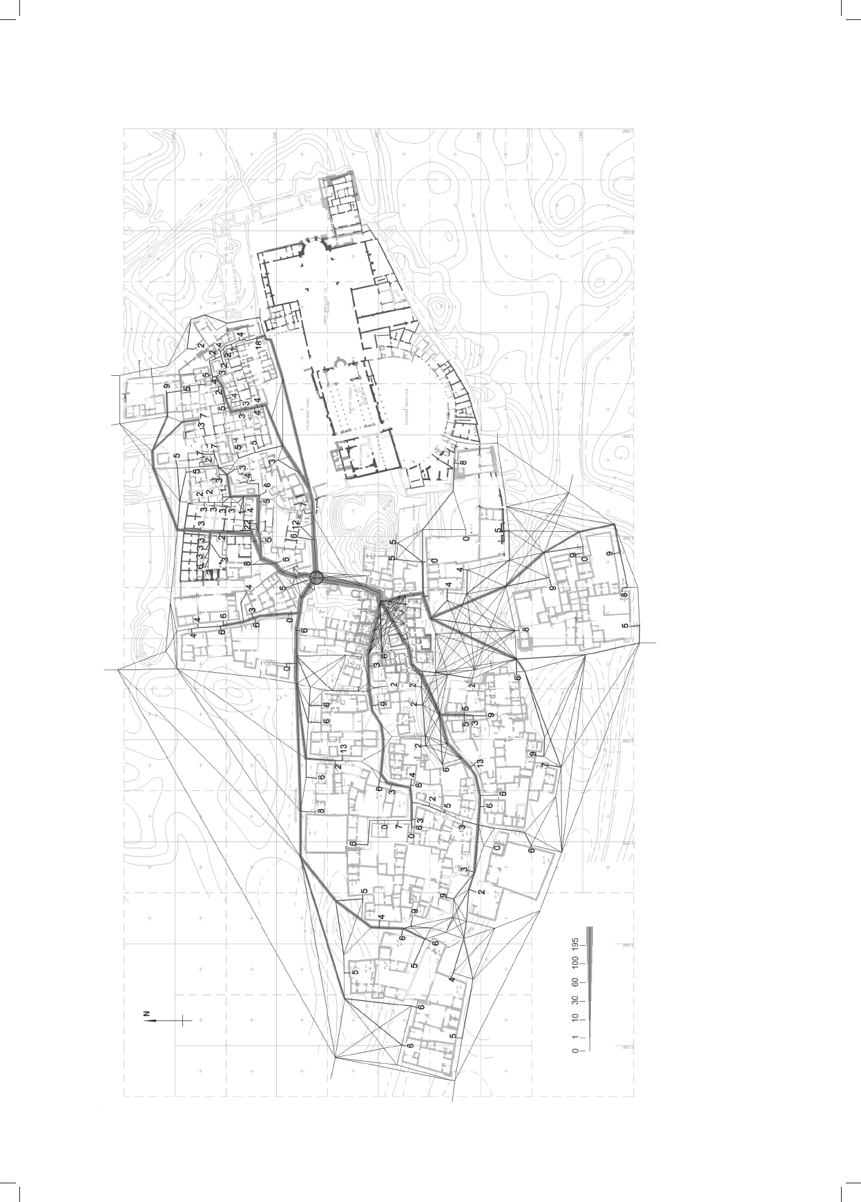
stwach. Dla każdej z trzech hipotez przygotowano odręb-
ny plan przedstawiający siatkę możliwych połączeń ko
mu nikacyjnych, który stanowił materiał wyjściowy do
dalszych analiz (il. 5–7).
W oczywisty sposób tak przygotowane dane mają swoje
ograniczenia. Pierwszym jest przyjęcie założenia, że liczba
mieszkańców w poszczególnych domostwach odpowiada
realiom wczesnośredniowiecznej Abû Mînâ. Trzeba mieć
jednak świadomość, że w tego typu badaniach natura do
stępnych danych charakteryzuje się z reguły małą wiary-
godnością statystyczną
12
. Istotną rolę odgrywa też fakt, że
po mimo wysiłków badaczy interpretacja takich danych
źród łowych jest w nieunikniony sposób obarczona pew
ną dozą subiektywizmu
13
. W naszej sytuacji stajemy więc
przed dylematem, czy poprzes tać na suchym relacjonowa
niu przy
padkowo ocalałych fragmentów przeszłości, czy też
ma my prawo pokusić się o próby jej rekonstrukcji, z na tury
rzeczy
ułomne, ale zawsze stanowiące krok w kie
runku po
znania – nawet jeśli w przyszłości zostaną one pod
dane kry
tyce. Wie rzymy, że mamy do tego prawo.
Kolejne ograniczenie związane jest z rekonstruowaną
siatką możliwych połączeń komunikacyjnych. Wspom
niana powyżej dynamika wzajemnych interakcji pomię-
dzy lokalizacją „usług” i domostw mieszkalnych oraz
fakt,
że nie mamy pełnego obrazu chronologii tych in ter ak cji
stanowią trudne wyzwanie. Jedyny spójny obraz, którym
11
Tabela 15 przedstawiona w pracy [5] podaje zrekonstruowaną
liczbę mieszkańców dla poszczególnych budynków w zachodniej części
osiedla, a tabele: 16 i 17 w części wschodniej.
12
Skomplikowane historyczne procesy – warunkujące przetrwanie
do naszych czasów fragmentów dawnej rzeczywistości, które moglibyśmy
traktować jako dane źródłowe – sprawiają, że zawsze mamy do czynie-
nia z wybiórczym i przypadkowym obrazem przeszłości.
13
Można w tym miejscu przytoczyć, nieodosobnioną zresztą, opi
nię prof. Daniela Beauvois: Każde pokolenie mierzy się z nią [historią]
na nowo, odkrywa nowe źródła, archiwa, dokumenty. Ja daję lu dziom
swoją narrację, ale po mnie przyjdzie ktoś inny i będzie się z tą ma terią
mierzył na nowo. Cytat pochodzi z wywiadu z Profesorem w Gazecie
Wrocławskiej z 27.11.2010, Nie istnieje żadna obiektywna histo ria;
http://www.gazetawroclawska.pl/artykul/337895,nieistniejezadna
obiektywnahistoria,5,id,t,sa.html [data dostępu: 6.10.2017].
the eastern, ecclesiastical part of the settlement is 265
people, whereas that number for its western, secular part
is 452 people. In our analysis the number of residents in
individual dwellings shall be the weight with which they
could have been drawn towards the most convenient area
where the shops and workshops could have been located.
Another element of the simulation shall be the layout
of the early medieval settlement with the network of all
possible connections along the existing streets and the
number of residents in individual dwellings. A separate
plan with a network of possible connections was prepared
for each of the three hypotheses, which was the input
material for further analyses (Fig. 5–7).
Obviously, such prepared input data have some limita-
tions. The first of them is the assumption that the number
of residents in individual dwellings reflects the reality of
early medieval Abû Mînâ. It should be remembered that
the nature of available input data in this type of research
is by the rule of poor statistical credibility
12
. Furthermore,
a significant role is played by the fact that in spite of the
researchers’ efforts the interpretation of such source data
is always somewhat subjective
13
. In our situation we face
then the dilemma whether it is enough to describe ran-
domly preserved original fragments of the past or we are
entitled to make attempts at reconstructing it, which, in
spite of being imperfect, still would always be a step to
wards new knowledge – even though in the future it could
be criticized. We believe that we have the right to do it.
Another limitation regards the reconstruction of the
network of possible pedestrian connections. The men-
tioned above dynamics of mutual interactions between
the location of “services” and residential dwellings as
well as the fact that we do not have the full chronology of
those interactions pose a difficult challenge. The only
coherent picture at our disposal is the final layout of
pedestrian connections in the last stage of existence of
Abû Mînâ. The relative chronology of the structures built
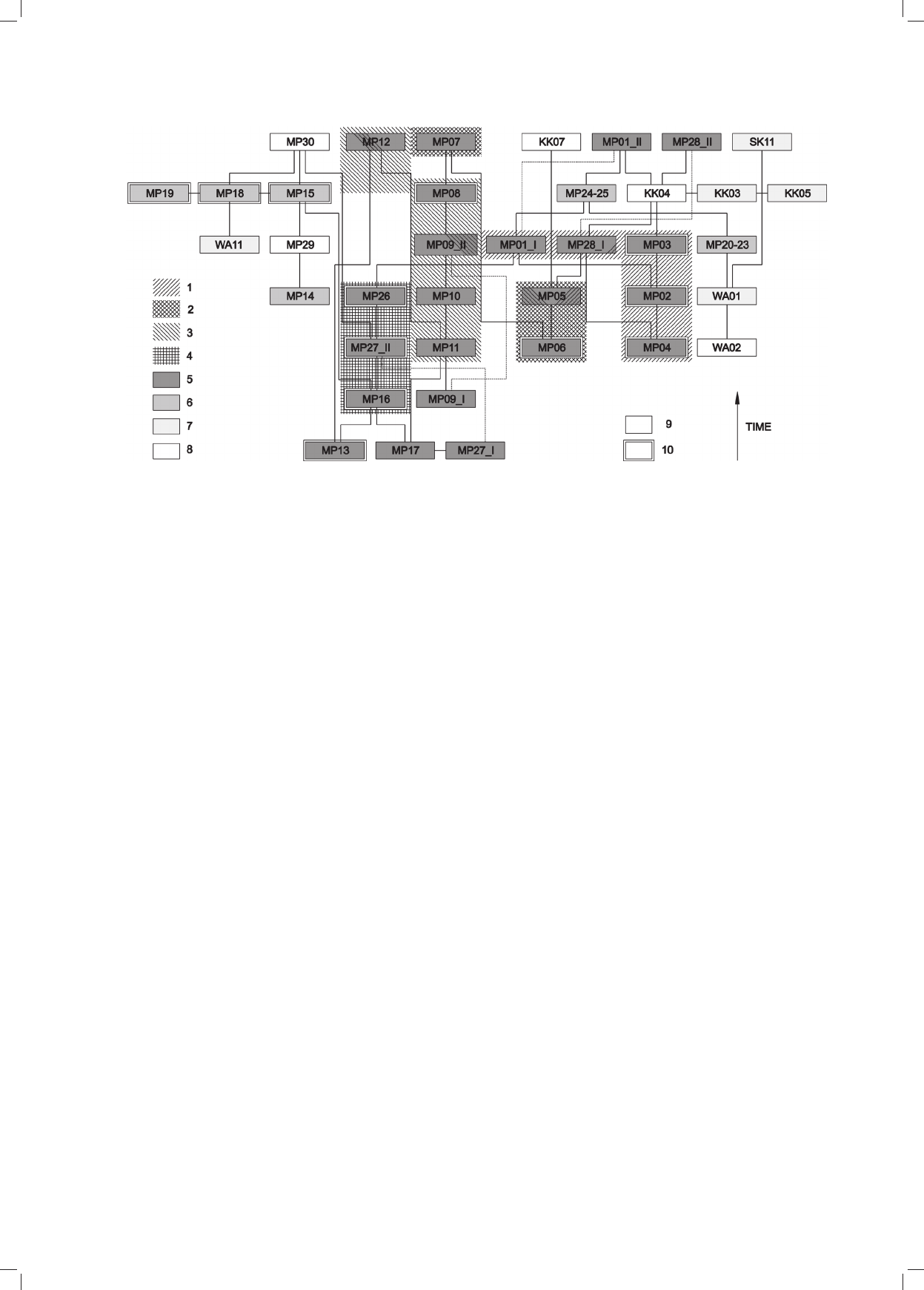
around the Market Place can prove helpful (Fig. 4).
It indicates that the complex of buildings MP 24–25
(Fig. 3) was built in the latest stage of development of
the surroundings of the Market Place. As it blocked the
im portant connection between the northwest corner of
the Market Place and the areas located further north
– which can prove highly significant for the whole simu-
lation as it could distort the picture of the roads network
of the earlier stages – we decided not to take into account
the existence of that building in the network of pedestrian
12
Due to the complicated historical processes – determining the
preservation the original fragments of old reality until our times which
we could consider source data – we always have to deal with a selective
and incomplete picture of the past.
13
We could refer here to Professor Daniel Beauvois’s opinion
which is not that unique anyway: Each generation deals with it [history]
on its own, discovers new sources, archives, documents. I provide people
with my own narrative but there will be somebody else after me who will
have to deal with that matter again. The quote comes from the interview
with the Professor at “Gazeta Wrocławska” from 27.11.2010, Nie ist-
nieje żadna obiektywna historia; http://www.gazetawroclawska.pl/
artykul/337895,nieistniejezadnaobiektywnahistoria,5,id,t,sa.html
[accessed: 6.10.2017].
Zastosowanie algorytmów optymalizacyjnych/The use of optimization algorithms 9
dysponujemy, to finalny układ połączeń komunikacyj-
nych w ostatniej fazie istnienia Abû Mînâ. Pew ną pomocą
mo że nam służyć względna chronologia bu dowli wznie-
sionych wokół Placu Targowego (il. 4). Wy nika z niej, że
ze spół budynków MP 24–25 (il. 3) powstał w naj póź
niejszej fazie formowania się otoczenia Placu Tar gowego.
Ponieważ zablokował on ważne z punktu widzenia komu-
nikacji połączenie północnozachodniego naroża Placu
Targowego z terenami położonymi dalej na północ – co
może mieć bardzo istotne znaczenie dla całej symulacji,
wypaczając obraz układu komunikacyjnego faz wcześ
niej szych – zdecydowaliśmy się nie uwzględniać istnienia
tego budynku w siatce połączeń komuni kacyjnych słu
żącej jako dane wyjściowe do poniższych analiz (il. 5–7).
Metoda analizy
Dotychczasowe badania nad dostępnością dla pieszych
(ang. walkability) były prowadzone głównie w kontekście
transportu, marketingu i jakości życia [9]–[12]. W przed-
stawionym przez nas opracowaniu analiza dostępności
dla pieszych wykorzystana została w celu ustalenia środ-
ków ciężkości dla trzech różnych hipotez rozkładu miesz-
kańców wczesnośredniowiecznego osiedla Abû Mînâ,
opisanych już w poprzednim rozdziale.
Zgodnie z przyjętym założeniem o organicznym roz-
woju osiedla, kształtowanego głównie przez czynniki po
daży, popytu oraz maksymalizacji zysku, Plac Targowy
po winien rozwinąć się w okolicach naturalnego środka cięż
kości osiedla, tak aby z jednej strony zapewnić do
godny
dostęp mieszkańców, a z drugiej maksyma lizować zysk
connections which serves as input data for the following
analyses (Fig. 5–7).
Method of analysis
The research which has been done so far on walkabil-
ity has been conducted mainly in the context of transpor-
tation, marketing, and the quality of life [9]–[12]. The
analysis of walkability in the study presented by us was
applied to determine the centroids for the three different
hypotheses of distribution of the residents of the early
medieval settlement in Abû Mînâ described already in the
previous chapter.
In compliance with the assumption of organic growth
of the settlement determined mainly by the supply and
demand as well as profit maximization the Market Place
should have developed in the area of the natural centroids
of the settlement. Such a location would have provided the
residents with a convenient access, maximize the profit of
the owners of the shops and workshops and increase the
chances of attracting as many clients as possible. In our
opinion the results of such analyses can also shed some
light on the issue of the end of pilgrimages to Abû Mînâ
and possible functional and economic relations be tween
the secular and ecclesiastical part of the settlement.
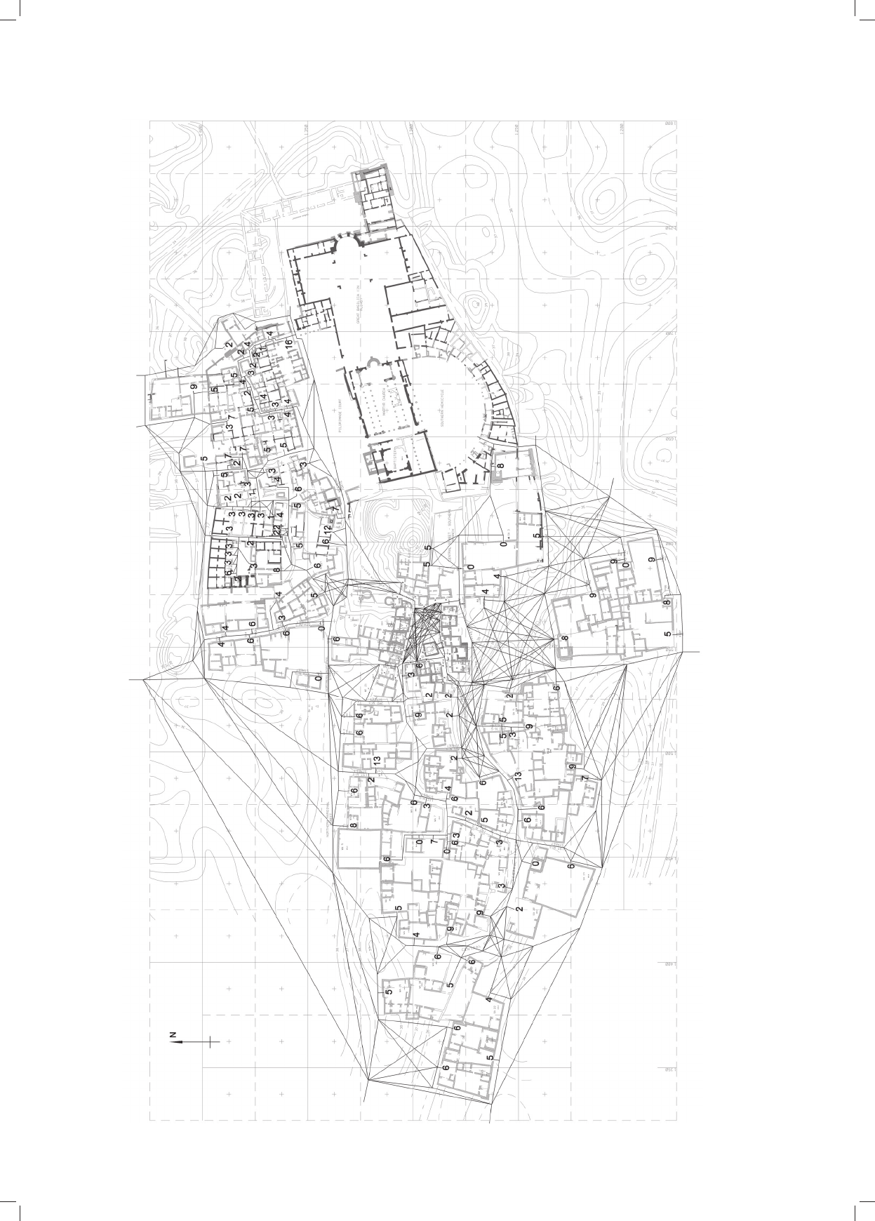
In the presented analyses the centroid of the settlement
is understood as a place in the network of pedestrian
connections for which the sum of access roads for all re
si dents is as low as possible. It is then a singlecriterion,
twodimensional optimization problem where one of the
va riables selects a line in the network of pedestrian
Il. 4. Względna chronologia budynków wokół Placu Targowego w Abû Mînâ: 1 – północna pierzeja Placu Targowego,
2 – wschodnia pierzeja Placu Targowego, 3 – południowa pierzeja Placu Targowego, 4 – zachodnia pierzeja Placu Targowego,
5 – sklepy i warsztaty położone bezpośrednio przy Placu Targowym, 6 – sklepy i warsztaty położone poza Placem Targowym, 7 – piekarnie,
8 – inne budynki, 9 – sklepy i warsztaty z jednym pomieszczeniem, 10 – sklepy i warsztaty z dwoma pomieszczeniami (oprac. J. Kościuk)
Fig. 4. Relative chronology of the buildings around the Market Place: 1 – northern side of the Market Place, 2 – eastern side of the Market Place,
3 – southern side of the Market Place, 4 – western side of the Market Place, 5 – shops and workshops located directly by the Market Place,
6 – shops and workshops located outside of the Market Place, 7 – bakeries, 8 – other buildings,
9 – shops and workshops with a single room, 10 – shops and workshops with two rooms (drawn by J. Kościuk)

10 Jacek Kościuk, Judyta Cichocka
właścicieli sklepów i warsztatów – czyli zwiększać szanse
pozyskania najliczniejszej klienteli. W naszym rozumie-
niu wyniki tych analiz mogą także rzucić nowe świa tło na
problem końca ruchu pielgrzymkowego do Abû Mînâ
i ewentualnych relacji funkcjonal noeko no micz
nych po
między świecką a eklezjastyczną częścią osiedla.
W prezentowanych analizach środek ciężkości osiedla
rozumiany jest jako miejsce w sieci połączeń komunika-
cyjnych, dla którego suma dróg dojścia dla wszystkich
mieszkańców jest możliwie najniższa. Jest to więc jedno-
kryteriowy, dwuwymiarowy problem optymalizacyjny,
gdzie jedna ze zmiennych wybiera linię w sieci połączeń
komunikacyjnych, a drugi parametr określa położenie
punktu na wybranej linii. Tak wybrane miejsce stanowi
rozwiązanie o pewnej jakości, którą określa przedstawio-
na poniżej funkcja celu:
gdzie:
f (w, p)
–
to funkcja celu rozumiana jako średnia ważo-
na wszystkich najkrótszych ścieżek między wejściami do
zabudowań mieszkalnych a środkiem ciężkości, dla której
wagą jest liczba mieszkańców korzystających z poszcze-
gólnych ścieżek,
p
–
oznacza długość najkrótszej ścieżki dojścia pomię-
dzy wejściem do zabudowania mieszkalnego a środkiem
ciężkości, obliczoną z pomocą kalkulatora topologii linio-
wej wykorzystującego algorytm A*
14
,
w – to waga dla poszczególnych ścieżek, reprezentowa-
na
przez liczbę mieszkańców korzystających z konkretnej
ścież
ki, czyli liczba mieszkańców startująca z ko res pon
du
ją ce go dla danej ścieżki punktu początkowego, a więc w kon
sekwencji
liczba mieszkańców danego zabudowania
15
,
N
–
oznacza liczbę punktów startowych, czyli liczbę
budynków mieszkalnych uwzględnianych dla danej hipo-
tezy; dla hipotezy I
N
=
143, dla hipotezy II
N
=
114, a dla
hi potezy III
N
=
115.
Funkcja celu umożliwia bezpośrednie porównanie roz-
patrywanych rozwiązań. Punkty z niższą wartością funk-
cji celu są jakościowo lepszymi rozwiązaniami, ponieważ
reprezentują miejsca o krótszym średnim dystansie dla
każdego mieszkańca, a więc są lepszymi kandydatami na
poszukiwany środek ciężkości osiedla.
Jakościowe porównanie generowanych rozwiązań po z
wala algorytmom optymalizacyjnym uczyć się, gdzie po
szu-
kiwany punkt (środek ciężkości) może znaleźć się na siatce
ulic. W naszych badaniach użyliśmy algorytmu na leżącego
do kategorii metod inteligencji rozproszonej (ang. Particle
Swarm Optimization – PSO). Proces został przeprowadzo-
ny z użyciem optymalizatora Silvereye [14] i po
zwo lił
wyznaczyć środki ciężkości dla poszczególnych hipo tez.
W kolejnych ewaluacjach algorytm zmieniał para met ry
symulacji, które wyznaczają położenie potencjalnego
14
Algorytm A* jest algorytmem, który posługuje się heurystyką
w celu znalezienia najkrótszej ścieżki w grafach ważonych [13].
15
W tym miejscu przyjęto założenie, że dla poszczególnych do
-
mostw potencjalne zainteresowanie urządzeniami handlowymi będzie
proporcjonalne do liczby mieszkańców w danym domostwie.
connections and the other parameter determines the loca-
tion of the point on the selected line. The place selected in
this way is the result of certain quality which is expressed
in the following objective function:
where:
f (w, p)
–
is the objective function understood as
a weight ed average of all shortest paths between the
entries to the residential buildings and the centroid for
which the weight is the number of residents using the
individual paths,
p
–
is the length of the shortest path between the entry
to the residential building and the centroid calculated with
the use of the linear topology calculator using algorithm
A*
14
,
w
–
is the weight for individual paths represented by the
number of residents using a specific path, that is the num-
ber of residents starting from the starting point corre-
sponding to a specific path, that is consequently the num-
ber of residents of a given building
15
,
N
–
is the number of starting points that is the number
of residential buildings taken into account for a given hy
po thesis; for hypothesis I N = 143, for hypothesis II N = 114,
and for hypothesis III N
=
115.
It is possible to use the objective function to directly
compare the results in questions. The points of the lowest
value of the objective function are qualitatively better
results because they represent the places of shorter aver-
age distance for each resident and consequently they are
better candidates to be the centroid of the settlement.
The qualitative comparison of the generated results
enables the optimization algorithms to learn where the
centroid can be located in the network of streets. We used
in our research the algorithm from the category of Par t-
icle Swarm Optimization (PSO). The process was con-
ducted with the use of Silvereye optimizer [14] and it
helped to determine the centroids for each of the hypoth-
eses. In subsequent evaluations, the algorithm changed
the parameters of simulation which determine the loca-
tion of the potential centroid, trying to minimize the ob
jective function after each iteration
16
. In other words, the
al gorithm was trying to find the global minimum of the
function. The input parameters for the minimum value of
the objective function determine the point which is the
centroid. Due to the heuristic character of PSO algo rithm,
the optimization process was conducted ten times for
each hypothesis and the effects presented in the following
paragraphs are the best results found after the end of all
10 processes.
14
Algorithm A* is the algorithm which uses heuristics to find the
shortest path in weighted graphs [13].
15
An assumption was made here that for individual dwellings the
potential interest in public amenities shall be proportional to the number
of residents in a given dwelling.
16
For PSO one iteration has a specific number of evaluations cor-
responding to the number of particles, in the described process each
iteration had 20 evaluations.
N
i
i
N
i
ii
w
wp
pwf
1
1
),(
N
i
i
N
i
ii
w
wp
pwf
1
1
),(
Zastosowanie algorytmów optymalizacyjnych/The use of optimization algorithms 11
Il. 5. Siatka połączeń komunikacyjnych dla hipotezy I (oprac. J. Kościuk)
Fig. 5. Network of pedestrian connections for hypothesis I (drawn by J. Kościuk)
12 Jacek Kościuk, Judyta Cichocka
Il. 6. Siatka połączeń komunikacyjnych dla hipotezy II (oprac. J. Kościuk)
Fig. 6. Network of pedestrian connections for hypothesis II (drawn by J. Kościuk)
Zastosowanie algorytmów optymalizacyjnych/The use of optimization algorithms 13
Il. 7. Siatka połączeń komunikacyjnych dla hipotezy III. Środek ciężkości Placu Targowego oznaczony czarnym punktem ●
, poszukiwaną wartość zmiennej w oznaczono jako X (oprac. J. Kościuk)
Fig. 7. Network of pedestrian connections for hypothesis III. The centroid of the Market Place marked with a black dot ●
, the requested value of the variable w is marked as X (drawn by J. Kościuk)

14 Jacek Kościuk, Judyta Cichocka
środka ciężkości, starając się w następnej iteracji
16
mini-
malizować funkcję celu. Innymi słowy, algorytm dążył do
znalezienia globalnego minimum funk cji. Pa rametry wej-
ściowe dla minimalnej wartości funkcji celu określają
punkt, którym jest środek ciężkości. Ze względu na heury-
styczny charakter algorytmu PSO, dla każdej hi potezy
proces optymalizacji został przeprowadzony dzie
sięciokrotnie, a wyniki prezentowane w kolejnych pa
ragrafach są najlepszymi rozwiązaniami znalezionymi po
zakończeniu wszystkich 10 procesów.
Dyskusja wyników i wnioski
Symulacje przeprowadzone dla trzech hipotez przynio-
sły interesujące wyniki, które mogą stanowić przyczynek
do dalszej dyskusji nad rozwojem, a zarazem zmierzchem
wczesnośredniowiecznej Abû Mînâ.
Symulacja dla hipotezy I
Symulowany środek ciężkości dla układu obejmujące-
go mieszkańców zarówno wschodniej, eklezjastycznej
części osiedla, jak i zachodniej – świeckiej wypada na
północny wschód od faktycznej lokalizacji wczesnośre-
dniowiecznego Placu Targowego, wykazując wyraźne
ciążenie w kierunku części eklezjastycznej.
Jeśli więc przyjąć, że nasze założenie, iż zasady organicz
nego rozwoju, a w szczególności czynniki podaży, po py tu
i maksymalizacji zysku jako głównego czynni ka kształ
tującego wczesnośredniowieczne osiedle są po prawne,
to
wnio skować można, że eklezjastyczna część
osied la nie
od gry wała istotnej roli w lokalizacji Placu Tar gowego.
W przeciwnym wypadku powinien on był się znaleźć bli
żej znaku X zaznaczonego na ilustracji 7 –
nota bene,
właś nie w miejscu, gdzie w okresie świetności Abû Mînâ
(VI w.) znajdowały się liczne sklepy i warsztaty ulokowane
w północnym portyku otaczającym Dzie dziniec Piel grzy
mów przed Bazyliką Grobową [5, s. 40, ryc. 18].
Wniosek, że eklezjastyczna część osiedla nie odgrywa-
ła istotnej roli w lokalizacji Placu Targowego, zgodny jest
ze zgłaszanymi już powyżej wątpliwościami, czy kler i służ
ba kościelna korzystały na co dzień ze skupionych tam skle
pów i warsztatów.
Warto też zwrócić uwagę na ciąg komunikacyjny naj-
bardziej obciążony ruchem mieszkańców (il. 8). Łączy on
symulowany środek ciężkości całego układu z północno-
wschodnim narożnikiem Placu Targowego, gdzie sku-
mulowała się więk szość ruchu pochodzącego właśnie
z zachodniej – świeckiej części osiedla.
Symulacja dla hipotezy II
Ciekawe wyniki przyniosła także symulacja dla hipote
zy II, czyli sytuacji, kiedy Plac Targowy miałby służyć
wy łącz nie mieszkańcom zachodniej – świeckiej części
osiedla.
16
Dla PSO jedna iteracja zawiera określoną liczbę ewaluacji od
powiadającą liczbie cząsteczek, w opisanym procesie każda iteracja
za wierała 20 ewaluacji.
Discussion of the results and conclusions
The simulations conducted for three hypotheses pro-
vided interesting results which might contribute to the
further discussion on the development as well as the fall
of early medieval Abû Mînâ.
Simulation for hypothesis I
The simulated centroid for the layout including the
residents both of the eastern, ecclesiastical and the west-
ern, secular part of the settlement was established north
east of the actual location of the early medieval Market
Place, demonstrating an evident draw in the direction of
the ecclesiastical part.
If it is assumed that the principles of organic growth,
and especially the supply and demand as well as profit
maximization, being the main factors shaping the early
medieval settlement, are correct, then it can be concluded
that the ecclesiastical part of the settlement did not play
a significant role in the location of the Market Place.
Otherwise, it would have been located in the neighbor-
hood of the point marked as X in Figure 7 – in fact this is
the place where during its prosperity (the 6
th
century) Abû
Mînâ had numerous shops and workshops located in the
north portico surrounding the Pilgrimage Court in front
of Martyr Church [5, p. 40, Fig. 18].
The conclusion that the ecclesiastical part of the settle-
ment did not play a significant role in the location of the
Market Place is consistent with the doubts brought up
earlier whether the clergy and church staff used the shops
and workshops located there daily.
It should be noted that the heaviest traffic of the resi-
dents was along the pedestrian connections between the
simulated centroid of the whole layout and the northeast
corner of the Market Place with the most of traffic com-
ing from the western, secular part of the settlement
(Fig. 8).
Simulation for hypothesis II
Some interesting results were also provided by the
simulation for hypothesis II that is the situation when the
Market Place would have been used exclusively by the
residents of the western, secular part of the settlement.
As intuitively predicted, the centroid of the pedestrian
connections moved west, closer to the center of the west-
ern part of the settlement. Although it is not the location
suggested in the earlier publications [5, p. 151]
17
, it must
be kept in mind that the applied optimization algorithm
does not account for local topography [5]
18
– in this case
17
Fig. 35, p. 111 and Fig. 38, p. 114.
18
As already mentioned, this is a drawback of our simulation and
a solution to this problem would require introducing an additional
parameter which would take into account the gradient of individual sec-
tions of the network of possible pedestrian connections. It is, however,
difficult to determine the value of such a parameter and the introduction
of such a variable of estimate values only intuitively might affect the
results of the whole simulation in an unpredictable way.

Zastosowanie algorytmów optymalizacyjnych/The use of optimization algorithms 15
Zgodnie z intuicyjnymi przewidywaniami środek cięż-
kości układu komunikacyjnego przesunął się w kierunku
zachodnim, bliżej centrum zachodniej części osiedla. Nie
jest to wprawdzie lokalizacja sugerowana we wcześniej-
szych publikacjach [5, s. 151]
17
, ale musimy pamiętać, że
zastosowany algorytm optymalizacyjny nie uwzględnia
lokalnej topografii [5]
18
– w tym wypadku nachylenia
te renu, na którym znalazły się drogi komunikacyjne w tym
rejonie. W miejscu wskazanym przez algorytm stosunko-
wo strome zbocze o spadku w granicach 26% nie tylko
utrudniało poruszanie się, zachęcając do wyboru innych
dróg biegnących bardziej równolegle do poziomic, ale
i czyniło sam obszar mało przydatnym do zorganizowania
placu targowego. Najbliższy, względem wyznaczonego
w symulacji, teren sprzyjający lokalizacji targowiska po
ło żony jest nieco bardziej na północ, po północnej stronie
piekarni WA 11. Co ciekawe, w bezpośrednim sąsiedz-
twie znajdują się dwa sklepy (MP 19) izolowane od głów-
nego zespołu handlowego na Placu Targowym (il. 3). Jeśli
weźmiemy pod uwagę ustalenia dotyczące względnej
chronologii sklepów i warsztatów (il. 4), to okaże się, że
zarówno piekarnia WA 11, jak i sklepy MP 19 powstały
stosunkowo późno. Być może był to właśnie moment,
kiedy praktycznie ustał ruch pielgrzymkowy do Abû
Mînâ i dotychczasowe położenie Placu Targowego stało
się mało dogodne dla mieszkańców zachodniej części sta-
nowiących teraz jedyną klientelę. Dalsze badania tereno-
we mogą pozwolić na zweryfikowanie takiej hipotezy.
Ponownie warto zwrócić uwagę na ciąg komunikacyj-
ny najbardziej obciążony ruchem mieszkańców (il. 9).
Łączy on symulowany środek ciężkości całego układu,
tym razem z południowozachodnim narożnikiem Placu
Targowego, gdzie dla hipotezy II kumu lu je się większość
ruchu pochodzącego głównie z północnej – świeckiej
części osiedla. Zarówno więc w przypadku hipotezy I, jak
i II teren, gdzie faktycznie powstał Plac Targowy, jest
miejscem koncentracji ruchu dla obu symulacji.
Symulacja dla hipotezy III
Hipoteza III zakładała, że Plac Targowy służył miesz-
kańcom zachodniej, świeckiej części osiedla, a jednocześ
nie bliżej nieokreślonej grupie pielgrzymów, którzy nadal
odwiedzali centrum sakralne wokół grobu św. Me nasa.
Tym razem algorytm optymalizacyjny poszukiwał więc
odpowiedzi na pytanie, jak liczna musiała być grupa po
tencjalnych klientów Placu Targowego – zlokalizowane-
go tam, gdzie on się rzeczywiście znajduje – dla których
punktem wyjścia był plac przed Bazyliką Grobową.
Wyniki symulacji (il. 10) określiły liczebność takiej
grupy na mniej więcej 90 osób. Jeśli więc przyjąć, że fak-
tyczna lokalizacja Placu Targowego podporządkowała się
17
Ryc. 35, s. 111 i ryc. 38, s. 114.
18
Jak już wspomnieliśmy, stanowi to pewien mankament naszej
symulacji i rozwiązanie tego problemu wymagałoby wprowadzenia do
datkowego parametru, który uwzględniałby nachylenie poszczególnych
odcinków sieci możliwych połączeń komunikacyjnych. Trudno jest jed
nak określić wartości takiego parametru, a wprowadzenie takiej zmien-
nej o wartościach szacowanych jedynie intuicyjnie mogłoby w nie prze
widywalny sposób wpływać na wyniki całej symulacji.
the gradient of the area with the roads network. The rela-
tively steep slope with the gradient of up to 26% in the
place indicated by the algorithm not only made it difficult
to move but also encouraged the choice of other roads
going more parallel to the contour lines and made the area
itself less useful to organize the Market Place. The area
which would be closest to the point indicated in the simu-
lation and topographically useful for the location of a mar
ket place is situated slightly more to the north on the
northern side of the bakery WA 11. Interestingly, there are
two shops in the immediate neighborhood (MP 19) iso-
lated from the main commercial compound in the Market
Place (Fig. 3). If findings regarding the relative chronolo
gy of shops and workshops are taken into account (Fig. 4),
it will turn out that both the bakery WA 11 and the shops MP
19 were built relatively late. It might have been when the
pilgrimages to Abû Mînâ practically stopped and the loca-
tion of the Market Place became less convenient for the
residents of the western part who were then the only clients.
Further field research might help verify such a hypothesis.
It is worth drawing attention again to the pedestrian
connections with the heaviest traffic of the residents
(Fig. 9). It combines the simulated centroid of the whole
layout this time with the southwest corner of the Market
Place where for hypothesis II most traffic coming mainly
from the northern – secular part of the settlement accumu-
lates. Both in case of hypothesis I and hypothesis II the
area where the Market Place was actually located is the
place of concentration of traffic for both simulations.
Simulation for hypothesis III
Hypothesis III assumed that the Market Place was
used by the residents of the western, secular part of the
settlement as well as some unspecified group of pilgrims
who still visited the religious center around the tomb of
St Menas. This time then the optimization algorithm was
looking for the answer to the following question: How big
was the group of potential clients of the Market Place in
its actual location for whom the starting point was the
square in front of Martyr Church?
The results of the simulation (Fig. 10) determined the
number of such a group at more than 90 people. If then it
is assumed that the actual location of the Market Place
was governed by the organic processes suggested by us, it
should be stated that it was affected by the additional
group of potential clients approaching from the direction
of Martyr Church. That group accounted for about 12%
of the whole population of early medieval Abû Mînâ or
about 20% of the residents of its western, secular part. In
both cases it is then a significant part of the whole popula-
tion. Unfortunately, we cannot unequivocally define the
composition of that group. It might have been exclusively
pilgrims or, in spite of the doubts brought up earlier, some
residents (about 34%) of the eastern, ecclesiastical part of
the settlement or both in an unspecified proportion.
Regardless of the assumption of one of the three inter-
pretations the results of the simulation conducted for
hypothesis III indicate the influence of the cult of
St Menas – either in the form of the continuation of the
16 Jacek Kościuk, Judyta Cichocka
Il. 8. Wyniki symulacji dla hipotezy I. Grubość linii obrazuje symulowane potoki ruchu na poszczególnych ciągach komunikacyjnych (oprac. J. Cichocka)
Fig. 8. The results of the simulation for hypothesis I. The thickness of the line demonstrates the simulated flows of traffic in individual pedestrian connections (drawn by J. Cichocka)
TRAFFIC LOAD
Zastosowanie algorytmów optymalizacyjnych/The use of optimization algorithms 17
Il. 9. Wyniki symulacji dla hipotezy II. Grubość linii obrazuje symulowane potoki ruchu na poszczególnych ciągach komunikacyjnych (oprac. J. Cichocka)
Fig. 9. The results of the simulation for hypothesis II. The thickness of the line demonstrates the simulated flows of traffic in individual pedestrian connections (drawn by J. Cichocka)
TRAFFIC LOAD
18 Jacek Kościuk, Judyta Cichocka
Il. 10. Wyniki symulacji dla hipotezy III. Grubość linii obrazuje symulowane potoki ruchu na poszczególnych ciągach komunikacyjnych (oprac. J. Cichocka)
Fig. 10. The results of the simulation for hypothesis III. The thickness of the line demonstrates the simulated flows of traffic in individual pedestrian connections (drawn by J. Cichocka)
TRAFFIC LOAD

Zastosowanie algorytmów optymalizacyjnych/The use of optimization algorithms 19
sugerowanym przez nas organicznym procesom, stwier-
dzić wypada, że miała na nią wpływ dodatkowa grupa
potencjalnych klientów nadchodząca od strony Bazyliki
Grobowej. Grupa ta stanowiła około 12% całej populacji
wczesnośredniowiecznej Abû Mînâ lub circa 20% miesz-
kańców jej zachodniej, świeckiej części. Zarówno w jed-
nym, jak i drugim przypadku jest to więc znacząca część
całej populacji. Nie możemy niestety jednoznacznie zde-
finiować składu tej grupy. Mogli to być zarówno wyłącz-
nie pielgrzymi lub też, pomimo zgłaszanych już wątpli-
wości, część (około 34%) mieszkańców wschodniej,
eklezjastycznej części osiedla, jak i jedni i drudzy w bli-
żej nieokreślonej proporcji.
Niezależnie od przyjęcia jednej z tych trzech interpre-
tacji wyniki symulacji przeprowadzonej dla hipotezy III
wskazują na wpływ kultu św. Menasa – czy to w postaci
ciągle jeszcze trwającego ruchu pielgrzymkowego, czy
też ciągle funkcjonującej enklawy kościelnej – na kształ-
towanie się układu funkcjonalnego wczesnośredniowiecz
nego osiedla w Abû Mînâ.
Reasumując, uznać możemy, że przedstawiony w hipo-
tezie III model interakcji pomiędzy Placem Targowym
a poszczególnymi rejonami zabudowy oraz (co istotne)
potencjalnym ruchem pielgrzymkowym jest najbardziej
przekonywający.
Wnioski końcowe
Przeprowadzone symulacje i ich wyniki wskazują po raz
kolejny na możliwość zastosowania algorytmów optyma
lizacyjnych we wspomaganiu rozwiązywania rzeczywis
tych problemów, w tym przypadku nie tylko projektowych.
Adaptacja algorytmów symulacyjnych do analizy
kształ
towania funkcjonalnego wczesnośredniowiecznego osied
la Abû Mînâ pozwoliła na weryfikację przyjętych hi po tez.
Uzyskane wyniki mogą świadczyć o potencjale przed sta wio
nych metod w wyjaśnianiu rozwoju urbanistycznego miast
i osiedli zarówno tych współczesnych, jak i historycznych.
W stosunku do poprzednich implementacji algoryt-
mów optymalizacyjnych stosowanych w rozwiązywaniu
problemów związanych z przyjaznością dla pieszych [15]
rozwinięto strategię wyznaczania środków ciężkości po
przez wzbogacenie funkcji celu o dodanie wag dla jedno-
stek mieszkaniowych, a także bardzo dokładne określenie
punktów startowych – wejść do zabudowań mieszkal-
nych. Jedynym czynnikiem wprowadzającym niepewność
co do wiarygodności otrzymanych wyników jest wspom
niany już brak uwzględnienia rzeźby terenu, która mo gła
determinować preferencje wyboru dróg dojścia do Pla cu
Targowego.
pilgrimages or the activities of the church enclave – on
the shaping of the functional layout of the early medieval
settlement in Abû Mînâ.
Summing up, it can be assumed that the model of the
interaction between the Market Place and individual resi-
dential areas of the city and (more importantly) the poten-
tial pilgrimage traffic presented in hypothesis III is the
most convincing.
Final conclusions
The simulations which were conducted and their
results indicate again a possibility of applying the optimi-
zation algorithms in support of solving real problems, in
this case not only design ones.
With the adaptation of the optimization algorithms to
ana lyze the functional development of the early medieval
settle ment in Abû Mînâ it was possible to verify the assum
ed hypotheses. The results can indicate the potential of the
presented methods in explaining the urban growth of both
modern and ancient cities and settlements.
Compared to previous implementations of the optimi-
zation algorithms applied in solving the problems con-
nected with pedestrianfriendliness [15] the strategy of
locating the centroids was developed by enhancing the
objective functions by adding the weights for the residen-
tial units as well as by determining highly precisely the
start ing points – entries into residential buildings. The
only factor causing some doubts as to the credibility of
the results is the failure to take the landscape into account
which might have determined the preferences of choice of
the roads leading to the Market Place.
Translated by
Tadeusz Szałamacha
[1] Ellis S.J.R., Pes Dexter. Superstition and the State in the Shaping of
Shopfronts and Street Activity in the Roman World, [w:] R. Lau
rence, D.J. Newsome (ed.), Rome, Ostia, Pompeii: Movement and
Space, Oxford University Press, London 2011, 160–173.
[2] Evangelidis V., Jones J., Dourvas N., Tsompanas M.A., Sirakoulis
G.Ch., Adamatzky A., Physarum machines imitating a Roman road
network: the 3D approach, „Scientific Reports” 2017, 7010, www.
nature.com/scientificreports, doi: 10.1038/s4159801706961y
[accessed: 15.11.2017].
Bibliografia /References

20 Jacek Kościuk, Judyta Cichocka
Streszczenie
Artykuł proponuje zastosowanie algorytmów optymalizacyjnych w badaniach organicznego rozwoju wczesnośredniowiecznej osady w Abû Mînâ
(Egipt). Na podstawie zrekonstruowanej liczby mieszkańców w poszczególnych zespołach zabudowy zaproponowano trzy hipotezy dotyczące
ich interakcji z zespołem sklepów i warsztatów, który powstał w specyficznej lokalizacji. Wyniki analizy rzucają nowe światło na ostatnią fazę
rozwoju Abû Mînâ.
Słowa kluczowe: Abû Mînâ, Egipt, wczesne średniowiecze, organiczny rozwój osadnictwa, algorytm optymalizacyjny
Abstract
The paper proposes the use of optimization algorithms in research on the organic development of an early medieval settlement in Abû Mînâ (Egypt).
On the basis of the reconstructed number of inhabitants in individual building complexes, three hypotheses regarding their interaction with a group
of stores and workshops that was created in a specific location were proposed. The results of the analysis shed new light the last phase of on Abû
Mînâ development.
Key words: Abû Mînâ, Egypt, early Middle Ages, organic settlement development, optimization algorithms
[3] Evangelidis V., Tsompanas M.A., Sirakoulis G.Ch., Adamatz ky A.,
Slime mould imitates development of roman roads in the Bal kans,
„Journal of Archaeological Science: Reports” 2015, Vol. 2, 264–281.
[4] Evangelidis V., Tsompanas M.A., Sirakoulis G.Ch., Adamatzky A.,
Application of Slime Mould Computing on Archaeological Re
search, [w:] A. Adamatzky (ed.), Advances in Physarum Machines,
Springer 2016, 349–372.
[5] Kościuk J., Wczesnośredniowieczna osada w Abû Mînâ, Oficyna
Wy dawnicza PWr, Wrocław 2009.
[6] Bouras Ch., City and Village: Urban Design and Architecture,
„Jahr buch der Österreichischen Byzantinistik” 1981, 31/2, 611–653.
[7] Kościuk J., The Market Place of the Mediaeval Settlement in Abû
Mînâ, [w:] M. Krause, S. Schaten (ed.), ΘΕΜΕΛΙΑ. Spätantike
und koptologische Studien. P. Grossmann zum 65. Geburtstag,
Reichert Verlag, Wiesbaden 1998, 187–224.
[8] Crawford J.S., The Byzantine Shops at Sardis, Harvard University
Press, Cambridge MA 1990.
[9] Hess D.B., Lombardi P.A., Policy support for and barriers to
transitoriented development in the inner city: Literature review,
„Trans portation Research Record” 2004, Vol. 1887, 26–33.
[10] Handy S., Smart growth and the transportation – land use connec-
tion: What does the research tell us?, „International Regional
Science Review” 2005, Vol. 28, Iss. 2, 146–167.
[11] Dorn J., Hidden in Plain Sight: Capturing the Demand for Housing
Near Transit, Center for TransitOriented Development, Oakland
CA 2004.
[12] Shapiro R.J., Hassett K.A., Arnold F.S., Conserving Energy and
Pre serving the Environment: The Role of Public Transportation,
Ame rican Public Transportation Association, Washington DC 2002.
[13] Hart P.E., Nilsson N.J., Raphael B., A Formal Basis for the Heu
ristic Determination of Minimum Cost Paths, „IEEE Transactions
of Systems Science and Cybernetics” 1968, Vol. 4, No. 2, 100–107.
[14] Cichocka J., Migalska A., Browne W.L., Ramirez E.R., SILVEREYE
– The Implementation of Particle Swarm Optimization Algorithm
in a Single Objective Design Optimization Tool, [w:] G. Çağdaş,
M. Özkar, L.F. Gül, E. Gürer (ed.), CAAD Futures 2017, CCIS 724,
Springer 2017, 151–169.
[15] Cichocka J.M., Generatywna optymalizacja w planowaniu prze-
strzennym – koncept miasta przyjaznego ruchowi pieszemu/Ge ne
rative design optimization in urban planning – walkabilityoptimi-
zed city, „Architectus” 2015, No. 1(41), 119–128.