2025
4(84)
Aneta Biała*
Greenery as a factor shaping urban planning:
the case of selected areas in Montreal
DOI: 10.37190/arc250410
Published in open access. CC BY NC ND license
Abstract
In today’s dynamic urban context, where cities play a crucial role in shaping the quality of life for residents, the role of greenery as a determinant
of public space has become a signicant issue. This article focuses on analyzing the impact of greenery on shaping the urban fabric using Montreal
as a case study, with particular emphasis on Mount Royal as a key element inuencing spatial planning and city development. The author explores
various aspects of this issue, including historical and cultural contexts, as well as practical implications. The genesis and development of the city
are presented, along with the role that Mount Royal has played in the urbanization process. The analysis also encompasses urban planning strategies
that focus on preserving and enhancing green spaces, such as parks and recreational areas, as well as sustainable city development. By delving into
the various aspects of greenery presence in Montreal, including urban planning, park distribution, and social initiatives related to green spaces, this
article aims to understand the complexity of the relationship between greenery and the shaping of public spaces in the context of this Canadian city.
The analysis sheds light on existing challenges related to maintaining and developing green areas, while also highlighting the benets of eectively
utilizing greenery as a key element of urban planning.
Key words: greenery, urban development, sustainable city, public space
Introduction
Greenery has accompanied humanity since ancient times
and has been the subject of numerous studies related to its
role in shaping urban spaces (Wolch, Byrne and Newell
2014; Wendel, Zarger and Mihelcic 2012; Tołwiński 1963;
Gyurkovich, Sotoca 2018). Its role in cities has evolved
over dierent historical epochs – initially serving practical
functions, later becoming a decorative element, and even-
tually combining both aspects (Gyurkovich, Sotoca 2018).
Nowadays, there is an increasing emphasis on the necessity
of protecting and developing green areas in cities, as well
as recognizing their positive impact. This phenomenon is
linked not only to improving the natural environment in
urbanized areas but also to providing residents with places
for recreation and relaxation in environments conducive to
their well-being. Gradually, people are also becoming more
and more aware of environmental issues and environmental
conservation. Urban green spaces play a signicant role in
urban planning as they are important indicators of quality
of life. They have a positive impact on the urban ecolog
-
ical environment, social and economic development, and
the physical and mental health of residents, both adults and
children (Markevych et al. 2017).
In contemporary metropolises, greenery has become an
essential component of the city’s spatial structure, contribut-
ing to a healthy living environment alongside other factors.
Contemporary green spaces, in addition to their aesthetic
and recreational functions, play a crucial role in carbon ab-
sorption, temperature regulation, and the reduction of urban
heat islands, which is of direct signicance in the context of
cities adapting to climate change (Markevych et al. 2017).
In the context of contemporary urban movement and its
consequences, greenery becomes a signicant part of res-
idential areas in large conurbations (Virtudes 2016). Some-
times, especially in the historic centres of large cities, there
is little greenery, and public spaces are dominated by paved
squares and streets (Whitford, Ennos, and Handley 2001).
This phenomenon occurs both in charming European cities
* ORCID: 0000-0002-8967-046X. Faculty of Architecture, Poz-
nan University of Technology, Poland, e-mail: aneta.biala@put.poznan.pl
110 Aneta Biała
and in other parts of the world. Therefore, there is a need to
achieve a balance between urban areas and nature, making
the integration of greenery an essential element of spatial
planning in cities (Kus, Felski 2018). The city’s image, an-
alysed through the structure of green spaces, is shaped by
various parks and green areas. These diverse forms include
both continuous and linear green corridors and areas, as
well as points with various functions, investments, and lev-
els of development. Street trees, avenues, and even individ-
ual trees or ower beds are also important aspects of green
perception. The urban layout is structured by greenery, serv-
ing a number of functions, including connecting, dividing,
blocking, isolating, obscuring, masking, as well as decora-
tive (Virtudes 2016; Kowalska-Koczwara et al. 2021). Ur-
ban green areas and parks often become distinguishing fea-
tures, identity elements, and symbols of the city.
Methods
The aim of this article is to analyze the historical develop-
ment of green spaces in Montreal and examine their role in
shaping public spaces in selected areas of the city. The core
objective of the research was to assess the impact of green
spaces on residents’ quality of life and the changes that have
occurred in these areas as urban development progressed.
Additionally, the analysis aimed to identify how urban green
spaces contribute to the spatial layout and urban structures
of the city. The research was divided into two main parts.
The rst part included a review of the literature and docu-
mentation related to the development of urban green spaces
in Montreal, considering both historical and contemporary
changes in their function and distribution. Historical doc-
uments, urban plans, and architectural studies were exam-
ined to trace the evolution of green spaces from the city’s
founding to modern-day urban green solutions. This section
aimed to identify key stages that inuenced the formation
and development of green spaces, as well as to understand
how urbanization has impacted these changes. The second
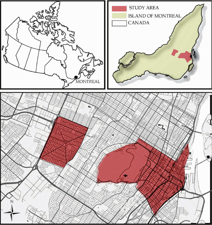
part of the research involved a detailed analysis of selected
districts in Montreal: Petite Bourgogne, Grintown, Mille
Carré Doré, Centre Ville, Vieux Montréal, and Town of Mont
Royal (Fig. 1). These districts were chosen based on their
di verse urban structure, degree of green space development,
and historical signicance. This study aimed to assess the
im pact of green spaces on the quality of public space and
explore how the presence of greenery shapes the functions
of these areas within an urban context.
To guide the research more precisely, the following re-
search questions were posed:
1. What changes in the distribution and structure of green
spaces have taken place in Montreal over the years, and how
have they inuenced the shaping of public spaces?
Fig. 1. Study area
(elaborated by A. Biała)
Il. 1. Obszar opracowania
(oprac. A. Biała)
Greenery as a factor shaping urban planning: the case of selected areas in Montreal 111
covered Mount Royal in the 16
th
century, it has stood out as
a unique landscape feature and a symbolic point of refer-
ence for residents and visitors, which became particularly
noticeable from the mid-19
th
century, when major urban
developments such as the creation of cemeteries, parks, and
monumental buildings emphasized its morphological spec-
icity. Located in the heart of Montreal, Mount Royal has
been a signicant factor shaping the city’s territory (Seline
1983; Marsan 1981; Debarbieux 1998).
The rst signs of green areas began to appear in Montreal
in the 1
st
half of the 19
th
century, but their signicance and
popularity noticeably increased in the 2
nd
half of the centu-
ry (Dagenais 2008). Squares, public plazas, and large parks
began to emerge throughout the city. Although they were
natural enclaves, they were primarily cultural spaces, reect-
ing many social values and ideals. Their creation aimed not
only to beautify the cities and promote their image but also
to de monstrate the economic progress of a given location, its
nan cial stability, and proper management. The concept of
park development envisioned them as pleasant and tranquil
places where people could walk, rest, and contemplate na-
ture. As Montreal grew and expanded, green spaces became
a way for municipal authorities to assert their presence on
the territory and extend the reach of urban inuence. Since
the 1890s, especially after 1900, public debates on the de-
velopment of parks and green areas have intensied (Dage-
nais 2008). The earlier concept of parks as city adornments
evolved towards a social need, indicating a growing demand
for access to green and recreational areas. Inuenced by the
reform movement focused on improving the quality of life
in industrial cities, the authorities of Montreal committed
to continuing the development of a network of recreational
spaces, especially in working-class neighbourhoods. Initial-
ly, parks were mainly perceived as places for aesthetic strolls
and contemplation, but their increasing popularity led to
them being viewed as venues for various forms of recreation,
attracting diverse groups of users. Consequently, city author-
ities began to equip parks with additional cultural elements,
This question sought to understand how the city’s de-
velopment, particularly its urbanization, has aected green
areas and their placement in public spaces.
2. What are the relationships between green spaces and
urban structures in selected Montreal districts, and how
have these relationships evolved over time?
This question focused on examining the interaction be-
tween urban green spaces and the built environment, ana-
lyzing how these elements inuence each other and what
changes have occurred in their relationship over time.
The research emphasizes the importance of green spaces
as elements that contribute to the sustainable development
of cities. In the context of Montreal, the analysis provides
va luable insights into the challenges and opportunities relat-
ed to the preservation and creation of urban green spaces, as
well as their role in mitigating the negative impacts of ur-
ba nization. This article attempts to summarize and organize
existing studies on urban green spaces in Montreal, high-
lighting key issues related to managing green spaces in rap-
idly growing cities.
Historical background and architectural
and town-planning development
Montreal, the largest city in the province of Quebec,
Ca nada, stands out not only for its rich culture and history
but also for its fascinating architecture, which has evolved
over decades. The city is located on the Island in the south-
western area of Quebec, at the conuence of the Ottawa and
Saint Lawrence rivers, encompassing approximately 315 km
of coastline (City of Montréal 2008). Being a modern and
densely populated urban agglomeration, it has many spatial
features inuenced not only by urban planning solutions but
also by the city’s geographical location. Riverbank ecosys-
tems and islands constitute signicant sources of biological
diversity. Green spaces account for 13% of the total area of
the city, including the over 200-hectare Mount Royal, which
the city commemorates in its name (City of Montréal 2008;
Ville de Montreal 2018; Seline 1983).
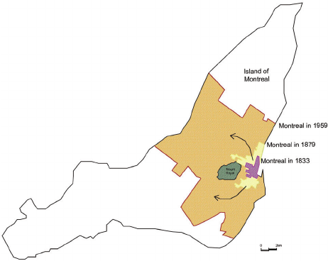
The territorial expansion of Montreal is a fascinating
is sue that illustrates changes in the urban structure and its
im pact on surrounding areas (Fig. 2). In 1642, settlers led
by Paul de Chomedey de Maisonneuve and Jeanne Mance
founded the settlement of Ville-Marie on the riverbank,
surrounded by the mountain, which became the nucleus of
today’s city (Seline 1983; Marsan 1981). The city began to
grow intensively during the industrialization period, espe-
cially in the 19
th
century. This period saw a great population
growth, and the industry and infrastructure development
prompted urban expansion. The initial stages of develop-
ment mainly focused around the central commercial and in-
dustrial areas. With Montreal’s population expansion, it ex-
tended its boundaries, incorporating surrounding areas and
villages, eventually encompassing all regions of the moun-
tain. In the initial phases of expansion, the city focused on
maintaining harmony between the urban structure and the
natural environment. In the context of urban development,
natural environmental elements, such as Mount Royal and
the Saint Lawrence River, played a crucial role in shaping
and expanding the city’s territory. Since Jacques Cartier dis-
Fig. 2. Montreal and its first transformations (elaborated by A. Biała,
based on https://imtl.org/image/cartes/small_scan083.jpg, 2024)
Il. 2. Montreal i jego pierwsze transformacje (oprac. A. Biała,
na podstawie: https://imtl.org/image/cartes/small_scan083.jpg, 2024)
112 Aneta Biała
thorities have turned their attention to sustainable develop-
ment, emphasizing environmental protection and creating
additional green areas. In 2005, Montreal adopted its rst
Sustainable Development Strategic Plan, which represents
a collective commitment to making sustainability the foun-
dation for the city’s future development. One of the plan’s
objectives was to protect biodiversity, natural habitats, and
green spaces, including increasing the area of protected nat-
ural habitats to 8% of the total area of the island under the
city’s jurisdiction (City of Montreal 2008). With its unique
topography and diverse landscape, Montreal began to regain
its reputation as a city where urban greenery harmoniously
coexists with development. Parks, gardens, and riverside
promenades create picturesque landscapes, attracting resi-
dents to use green spaces. Currently, the City of Montreal
plays a signicant role in promoting biodiversity initiatives
internationally (City of Montreal 2008).
In the research history of cities, the analysis of urban en-
vironments often remains overshadowed (Dagenais 2008).
Most scientists focused primarily on studying natural eco-
systems rather than the human environment. Cities were
con sidered less signicant in scientic research because
re searchers were primarily focused on eorts to halt envi-
ronmental degradation and condemn the excessive exploita-
tion of natural resources in the name of market economy.
In their eyes, cities were seen as enemies of nature, places
that harmed the surrounding environment. Although today
the relationships between social and natural environments
are the subject of intensive research by environmental his-
torians, studies on cities remain relatively neglected. In re-
cent years, ideas related to how people interact with their
surrounding nature have developed and extended beyond
activist and political aspects. Research on the history of
cities from an environmental perspective now requires an
analysis of the relationships between people and natural el-
ements, taking into account the dynamic changes occurring
on both sides of this equation. As historian Geneviève Mas-
sard-Guilbaud (Dagenais 2008) explains, the environmen-
tal approach to history rejects the concept that humans are
external observers of nature, instead accepting the idea of
their integral inclusion in the biosphere, from social units to
entire ecosystems.
Scaling space through greenery modelling
in selected examples
The urban layout of downtown Montreal is character-
ized by a grid of streets running perpendicular or parallel to
Mount Royal Park, creating a regular pattern with geometric
designs. This urban structure is partly inspired by the moun-
tain, located to the west of downtown, which is a dominant
feature of the city’s landscape (Fig. 3). Its presence not only
provides a picturesque backdrop but also inuences the orga-
nization of the urban space. The central area of Montreal fea-
tures a unique urban layout that has evolved over the years.
It is centered around two main axes – Rue Sainte-Catherine
and Rue Sherbrooke (Lord 2016) – serving as the commer-
cial, cultural, and business hub of the city. Rue Sainte-Cath-
erine, one of the main shopping thoroughfares, serves as the
primary east-west axis, oering numerous shops, boutiques,
such as playground equipment, picnic tables, pavilions, etc.,
emphasizing the change in perception of these green spaces
as functional recreational centres rather than merely aesthetic
natural havens (Dagenais 2008).
Since the establishment of the settlement, Mount Royal
has played an important role for its inhabitants, who often
went there for picnics or to enjoy the scenery (Debarbieux
1998). In the 1870s, eorts began to shape the area to meet
the social expectations of that time. It was then decided to
create two cemeteries and a public park on the mountain’s
grounds. This was aimed at preserving the natural heritage
but also providing residents with a place for rest and recre-
ation. Frederick Law Olmsted, a renowned landscape archi-
tect and the creator of Central Park in New York, was ap-
pointed to design this area (Debarbieux 1998). His creative
approach to park planning facilitated the harmonious inte-
gration of the mountain terrain into the urban fabric, while
emphasizing its uniqueness. Olmsted, staying true to his
ethical and aesthetic principles, adapted the concept of En-
glish landscape to the specics of the American context. He
introduced articial elements, while striving to make them
almost invisible in the natural environment. This rst en-
counter with diverse topography in his career prompted him
to reject the idea of a traditional park in favour of revealing
the “genius loci” – the characteristic spirit of that particular
place (Debarbieux 1998).
The increase in the city’s population necessitated the in-
cor poration of green areas into central city areas, providing
re sidents with access to parks and recreational areas. In
the post-war period, the phenomenon of suburbanization
emerged, where residents moved to the suburbs in search
of more space and tranquility. As part of this process, urban
greenery became a key element of spatial planning. The cre-
ation of new neighbourhoods involved the consideration of
green spaces, parks, and promenades to maintain a balance
between urban elements and the natural landscape. However,
due to intense and somewhat uncontrolled city development
between 1986 and 1994, half of the forests were built upon,
and between 1994 and 2001, another 750 ha of greenery
were lost (Oljemark 2002), ultimately losing 18% of green-
ery by 2005 (Pham et al. 2011). The city’s policy at the time
did not sit well with the residents, who placed more impor-
tance on maintaining existing green areas and
creating new
recreational spaces in the city. The inuence of residents on
the decision of city authorities regarding green areas can
be exerted through various mechanisms, including partic-
ipation in public consultations, petitions, actions of social
groups and non-governmental organization (NGO), and en-
gagement in electoral processes (Burstein 2003). Residents
often engage in active actions to express their opinions and
demands regarding the protection of green areas and the
development of recreational spaces in their area. This high-
lights the signicant role of society in shaping municipal
policies concerning the natural environment and recreation,
as well as the need for active dialogue between residents
and authorities in the decision-making process regarding
public spaces.
In the face of challenges related to overcrowding and
main taining quality of life, pressure from public opinion re-
pre sented by the Green Coalition on green issues, city au-
Greenery as a factor shaping urban planning: the case of selected areas in Montreal 113
cafes, and restaurants. It is also a venue for various urban
events, festivals, and parades, taking over this function from
Notre-Dame Street in the late 19
th
and early 20
th
centuries.
Meanwhile, Rue Sherbrooke, located slightly further north,
is known for its upscale shops, elegant restaurants, and cul-
tural institutions, such as museums and art galleries. The
central areas of Montreal also feature diverse architecture,
including both modern skyscrapers and historical buildings,
adding to the region’s unique character. Additionally, the
historic district of Vieux-Montreal occupies a central place,
where charming cobblestone streets, historic buildings, and
atmospheric squares can be found. Mount Royal is accessi-
ble via numerous pedestrian paths and bike trails, integrating
its surroundings with the city’s urban planning (Lord 2016).
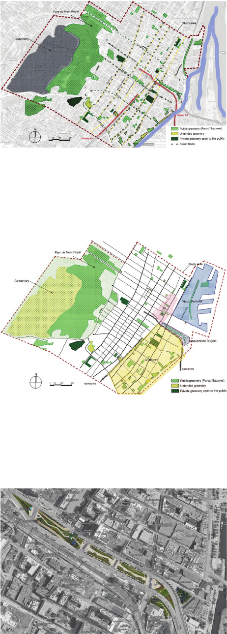
Despite the dense and compact urban development, the
streets in the analysed area of the city stand out for their
abundance of urban greenery. The largest concentration of
parks and street greenery is located along the St Lawrence
River in the Old Montreal area covered by the Old Montreal
Protection and Enhancement Plan, as well as in the area be-
tween Rue Notre Dame and Sainte Antoine O. Streets, which
corresponds to the Grintown district (Fig. 4). Thanks to the
Special Planning Program (SPP) for the Grintown area,
municipal actions in the public space have focused on trans-
forming social spaces, prioritizing the needs of residents
over vehicular trac. The project aimed to create eight new
green areas and public spaces. The total budget for public
investments in this regard amounted to 242 million dollars,
which were allocated for land acquisition for parks, the de-
velopment of existing parks and public spaces, street mod-
ernization, the purchase of certain signicant buildings, as
well as their revitalization and improvement of cultural func-
tions (City of Montreal 2017).
An interesting initiative is the green plaza that is part of
the Bonaventure Expy Street, created as part of the Bo na-
venture Project (Fig. 5). By demolishing the elevated sec -
tion of the highway and replacing it with a ground-level
boulevard, dedicated blocks will provide high-quality, safe,
and user-friendly public spaces between the streets of Wel-
lington and Notre-Dame (City of Montreal 2017).
The construction of the Ville-Marie highway also had
a negative impact on the Quartier International area, which
was signicantly damaged as a result of its construction.
Therefore, through the Special Planning Program (SPP),
eorts were made to repair and rebuild the public space in
this central part of the city. It was decided to combine the
idealistic modernist model, based on multi-layered vertical-
ity, with the typomorphological ideal of continuity of public
space both at the ground level as well as above and below
it. The aim was to create alternative pedestrian routes that
would harmoniously blend into the existing urban fabric,
connecting streets and sidewalks with underground urban
spaces. The remaining streets are characterized by an abun-
dance of street trees. City parks, cultural institutions, and
streets surrounded by greenery create a ohesive space that
allows residents to maintain a balance between urban life
and the natural environment. This symbiosis between the
downtown area and Mount Royal is a key characteristic of
Montreal, highlighting its uniqueness and attractiveness as
a place to live and work (City of Montreal 2017) (Fig. 6).
Fig. 3. Spatial configuration map of greenery
(elaborated by A. Biała, based on https://www.google.com/maps, 2024)
Il. 3. Mapa przestrzennej konfiguracji zieleni
(oprac. A. Biała, na podstawie: https://www.google.com/maps, 2024)
Fig. 4. Spatial configuration map of greenery
(elaborated by A. Biała, based on https://www.google.com/maps , 2024)
Il. 4. Mapa przestrzennej konfiguracji zieleni
(oprac. A. Biała, na podstawie: https://www.google.com/maps 2024)
Fig. 5. Bonaventure Project – replacing the existing viaduct
with a new surface level urban boulevard
(elaborated by A. Biała, based on https://www.google.com/maps2024)
Il. 5. Bonaventure Project – zastąpienie istniejącego wiaduktu
nowym, naziemnym bulwarem miejskim
(oprac. A. Biała, na podstawie: https://www.google.com/maps, 2024)
114 Aneta Biała
Urban analysis of downtown Montreal reveals the sig-
nicant impact that natural landscape elements, including
Mount Royal, have on the city’s structure. The street lay-
out in downtown Montreal, characterised by a regular grid
of perpendicular and parallel arteries, reects the inuence
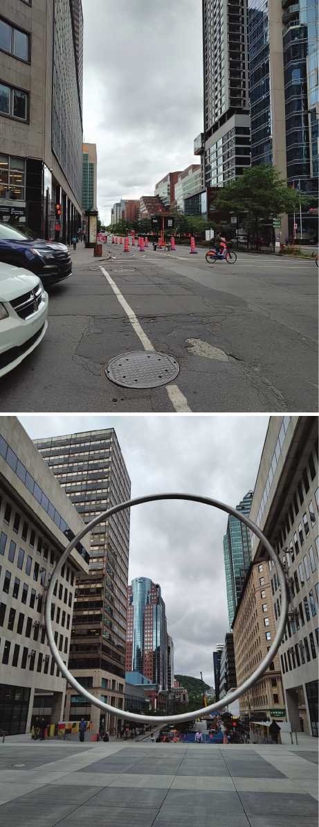
Fig. 6. Streets of Montreal (photos by A. Biała, 2023)
Il. 6. Ulice Montrealu (fot. A. Biała, 2023)
of Mount Royal, which serves as a dominant landscape fea -
ture aecting urban spatial organization. Historical and con -
temporary urban elements, such as Rue Sainte-Catherine and
Rue Sherbrooke, play key roles in commerce, culture, and
bu siness, dening the central areas of the city. On the one
hand, the regularity and geometric patterns in the urban lay-
out result from adaptation to the topography and function of
Mount Royal. On the other hand, this spatial planning fosters
dynamic development in commerce and cul ture. Contempo-
rary initiatives, such as the revitalization of Grintown and
the creation of the green square as part of the Bonaventure
Project, demonstrate a commitment to enhancing public
spaces and integrating greenery with urban design, un
der-
scoring the importance of urban greenery in improving res-
idents’ quality of life. Additionally, the negative impacts of
the Ville-Marie Expressway on the Quartier Internatio nal
area, which have been mitigated by the Special Planning
Prog ram, highlight the signicance of rebuilding and adapt-
ing public spaces in the context of urban modernization.
New urban solutions, such as multilayered verticality and
the integration of underground spaces, emphasize the eort
to harmoniously incorporate modern functions into the ex-
isting urban fabric.
As shown in Table 1, Montreal actively strives to improve
the quality of the natural environment through various ini-
tiatives, ranging from strategic municipal programs to local
community eorts and student-led projects. The city has ad-
opted an ambitious plan called the Montréal 2030 Strategic
Plan for Sustainable Development, which includes invest-
ments in the development of green spaces, increasing park
areas, and promoting public transportation and sustainable
modes of transportation. Under this plan, the city takes ac-
tions to increase the number of trees by regularly planting
new seedlings in selected urban areas, contributing to air
quality improvement and enhancing the aesthetics of the
place. Additionally, it continually invests in the development
of existing city parks and the creation of new recreational
areas, which helps improve the quality of life for residents
by encouraging outdoor activities and relaxation in a natural
environment (AIPH 2024).
Local communities and students from various universi-
ties engage in volunteer activities aimed at nurturing existing
green areas, whether it is by removing litter, planting plants,
or taking care of city parks. Students conduct research and
educational projects related to environmental protection,
promoting ecological awareness in the local community and
taking actions to improve green areas. As shown in Table 1,
Montreal undertakes a wide range of initiatives aimed at im-
proving the natural environment and increasing green spaces
in the city. These actions include both overall citywide and
neighbourhood-specic strategic programs, as well as active
involvement of the local community and students.
In the context of Montreal’s urban greenery, the role of
autonomous district units is a crucial factor in shaping the
landscape and distribution of green spaces throughout the
city. One of the most distinctive examples is the Mont-Roy-
al district, whose creation was directly linked to the rapid
development of Montreal in the early 20
th
century. How-
ever, this dynamic urban growth encountered signicant
topographical barriers, such as Mont Royal and the Saint

Greenery as a factor shaping urban planning: the case of selected areas in Montreal 115
Project name Project program
Programs at the city-wide level
Montréal 2030 Strategic Plan
2023–2030
The program seeks to speed up the shift towards ecological sustainability. This is achieved by prioritizing
biodiversity and green areas in decision-making processes and enhancing city practices through
incorporating the Climate Test and conducting gender-based intersectional analysis (GBA+) (AIPH 2024)
The Corridor écologiuqe
Darlington project
2020
This urban route will connect Mount Royal to the Hippodrome and the Outremont campus,
facilitating movement for both wildlife and people (Ouellet 2024)
Le Grand parc de l’Ouest
2023–2030
This project encompasses 3000 hectares designated for the creation of green spaces in the eastern part
of the island (Lau 2020)
Montreal’s Green Revival
2021
This plan outlines the city’s vision and priorities for revitalizing its expansive parks and natural areas
while promoting an active lifestyle for both current and future residents of Montreal. The plan consists
of four main components: protecting and connecting green spaces, enhancing access to water to strengthen
the island’s identity, improving the accessibility and resilience of Mount Royal, and promoting
year-round activity through a variety of recreational options and updates to sports facilities.
To drive Montreal’s environmental renewal, the Plan is organized around four pillars: Green Montreal,
Blue Montreal, Summit Montreal, and Active Montreal (City of Montreal 2021)
Local programs
The Old Montreal Protection
and Enhancement Plan
2013–2017
The aim of the program is to enhance the quality of life for residents by creating a better environment
for daily living, as well as preserving and promoting the cultural and historical heritage of the area
(City of Montreal 2017)
Special Planning Program (SPP)
for the Griffintown Area
2013–2030
The program is based on the redevelopment of existing public spaces, including redesigning over
10 kilometers of streets, and a property acquisition program aimed at creating eight new green areas
and public spaces (City of Montreal 2017)
Bonaventure Project
2011–2017
Replacing the existing Bonaventure viaduct highway, constructed in 1966, with a new surface-level
urban boulevard named Boulevard Robert-Bourassa (City of Montreal 2017)
Green Marine
2007
Green Marine is a comprehensive and inclusive initiative committed to enhancing environmental
performance beyond what is mandated by regulations. It upholds rigorous standards and promotes
transparency throughout its processes (Port of Montreal 2024)
Quartier des spectacles (QDS)
2002–
A strategy for green urbanization has been formulated in partnership with urban ecology experts
to address the impacts of climate change. This plan will be executed through initiatives focused
on enhancing green infrastructure, facilitating university research support, and organizing culturally
relevant programs (City of Montreal 2017)
Quartier international
de Montréal (QIM)
1997–2004
The redevelopment of the vicinity surrounding Victoria Square and the Palais des congrès de Montréal
entails various initiatives. These include the partial covering of the Ville-Marie expressway,
the construction and reconfiguration of public spaces, and the expansion or construction
of key buildings in the vicinity (City of Montreal 2017)
Bassins du Nouveau Havre
2008
The development strategy centres on enhancing the remnants of the former Lachine Canal pools,
formerly crucial components of Montreal’s inner port. It prioritizes sustainable development
approaches like rainwater harvesting, minimizing traffic density, and optimizing building efficiency.
This encompasses the establishment of Bassin-à-Bois Park and Bassin-à-Gravier Park,
Plac des Arrimeurs, and the implementation of a bioretention pond for collecting rainwater
(City of Montreal 2017)
Mount Royal enhancement plan
1992
Preserving and improving Mount Royal; ensuring accessibility and hospitality on the mountain;
establishing conducive circumstances for the protection and enhancement of Mount Royal
(City of Montreal 2009)
Social initiatives
Biodiversity enhancement project
in HEC Montréal
2021
The objective is to conserve and augment the biodiversity of ecosystems situated in the peripheral zones
of the school, situated within the Mount Royal heritage area. A series of interventions has been proposed,
encompassing the introduction of new arboreal and shrub species, safeguarding extant plant species
and pollinators, and implementing landscape modifications directed towards enhancing spatial quality
(HEC Montreal 2022)
200 Urban Gardens Project
2020
Through the establishment of 200 Urban Gardens, the objective is to establish an interconnected network
of green spaces that prioritize equity and serve multiple functions, fostering a culture of sustainability
across Montreal. The program seeks to transform neglected parcels of land into vibrant gardens,
revitalizing them to enhance the well-being of residents (McDevitt 2021)
Table 1. Green programs in city of Montreal (elaborated by A. Biała)
Tabela 1. Programy zieleni w mieście Montreal (oprac. A. Biała)
116 Aneta Biała
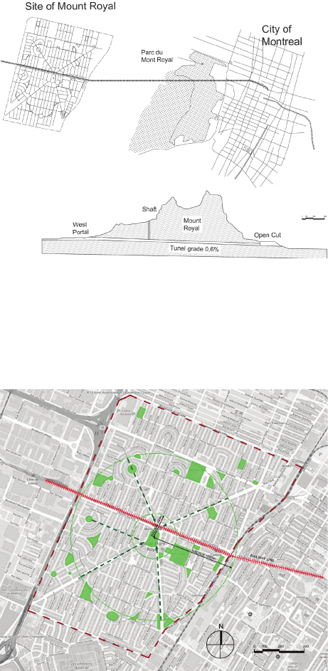
Lawrence River. These natural features limited the city’s ex-
pansion to the east and west, signicantly impacting the de-
velopment of transportation infrastructure, particularly rail-
ways. The inability to directly connect the city centre with
the areas located west of Mont Royal posed a serious chal-
lenge to urban development. In response to these diculties,
Montreal authorities undertook a costly but strategically es-
sential project: the construction of a tunnel beneath Mont
Royal (Fig. 7). This tunnel enabled the connection of the
city centre with the western part of the island, leading to an
increase in the attractiveness and value of land in that area.
Following these changes, and initiated by Canadian North-
ern Railway, the suburban district of Mont-Royal (TMR)
was established in the early 1910s. The creation of this dis-
trict not only inuenced Montreal’s urban development but
also signicantly contributed to the shaping of green urban
spaces in this part of the city (Zarabi et al. 2016).
Designed by Frederick Gage Todd, this urban area re-
ects the inuence of landscape architecture and urban plan-
ning principles, in accordance with the principles of the City
Beautiful and Garden City movements. The district com-
bines three dierent planning concepts: a grid plan, diagonal
boulevards from the City Beautiful movement, and a cur-
vilinear street pattern proposed by Frederick Law Olmsted
(Zarabi et al. 2016). The area mainly consists of residential
buildings, including both small single-family houses and
apartment complexes, hence the street grid was intentionally
tilted to maximize sunlight exposure. Businesses, schools,
and churches are located along strategic arteries, and the dis-
trict’s historical character is evident in both the main streets
and avenues and in the urban structure and numerous green
spaces. The combination of low-density residential devel-
opment with lush vegetation gives this suburb the charac-
teristic appearance of an urban park. At the heart of the ra-
dial city plan is the railway station and public square, where
two main avenues and the railway line converge. Parks
and open recreational spaces in this area are connected by
concentric roads, forming a winding, enclosed loop layout
within a 1 km radius (Fig. 8). Additionally, winding streets
enriched with greenery and diverse plantings complement
the area.
Urban greenery in Mont-Royal, which includes 30 parks
and over 70 other green spaces, plays a crucial role in en-
hancing the quality of life for its residents (Zarabi et al.
2016). The deliberate arrangement of green areas, combined
with residential and public spaces, fosters social integration
and supports the health and well-being of the community.
The fact that there is at least one tree per resident under-
scores the commitment to providing access to greenery and
its benets in everyday life. The layout of parks and open
recreational spaces in Mont-Royal, designed with concen-
tric roads and winding streets, creates a cohesive network
that encourages an active lifestyle and social interaction.
This approach to public space planning may serve as an in-
spiration for other cities aiming to develop sustainable and
functional urban areas. In summary, Mont-Royal exempli-
es the eective integration of greenery with urban plan-
ning, oering a model for future urban projects. It highlights
the importance of incorporating natural elements into urban
design to achieve sustainable development and enhance res-
idents’ quality of life in urban environments.
Conclusion
Based on the conducted research, it can be concluded
that urban greenery plays a signicant and multifaceted role
in shaping the urban structure of the historic parts of Mon-
treal, particularly evident in the studied districts of the city.
Historical analysis revealed that, especially during the early
phases of intense urbanization, the city’s development led to
substantial neglect and reduction of green areas. During this
period, the emphasis on infrastructure and urban expansion
resulted in the degradation of natural green spaces. Howev-
er, with the growth of ecological awareness and local com-
Fig. 7. Town of Mont Royal in relations to Mont Royal Tunnel
and central district of Montreal
(elaborated by A. Biała, based on Zarabi et al. 2016)
Il. 7. Miasto Mont Royal w relacji do tunelu Mont Royal i centrum
Montréalu, 1912 (oprac. A. Biała, na podstawie: Zarabi et al. 2016)
Fig. 8. Spatial configuration map of greenery of Mount Royal
(elaborated by A. Biała, based on https://www.google.com/maps 2024)
Il. 8. Mapa rozplanowania zieleni w Mount Royal
(oprac. A. Biała, na podstawie: https://www.google.com/maps 2024)
Greenery as a factor shaping urban planning: the case of selected areas in Montreal 117
munity pressures concerning quality of life, Montreal began
to take actions aimed at restoring green areas and integrat-
ing them into the urban fabric.
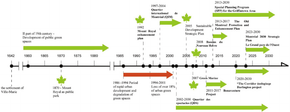
The timeline presented in Figure 9, showing key deci-
sions related to urban green spaces, highlights that despite
the degradation of greenery during periods of rapid city
de velopment, eorts were made to protect and preserve
areas like Mount Royal Park, which has maintained its sig-
nicance throughout the city’s history. A noticeable shift
in Montreal’s urban policy occurred after 2005, leading to
the introduction of numerous pro-environmental programs
aimed at revitalizing and increasing the accessibility of
green spaces. These initiatives include ambitious green in-
fra structure development plans, which focus not only on
restoring damaged areas but also on reinforcing them as
key elements of the city’s urban structure. This shift reects
a broader trend of adapting cities to contemporary challeng-
es, including climate change, air quality improvement, and
the reduction of urban heat islands. Natural landscape fea-
tures such as Mount Royal and the Saint Lawrence River
have historically played a pivotal role in shaping Montre-
al’s spatial development and continue to inuence the city’s
urban layout. These elements, beyond their aesthetic value,
have served as natural constraints, guiding the growth and
distribution of the city’s infrastructure. Contemporary ur
-
ban planning in Montreal increasingly incorporates these
features, integrating green spaces as an essential compo-
nent of urbanization processes.
This research also demonstrates that urban greenery in
central Montreal signicantly enhances the quality of public
spaces, providing areas for recreation and social integration.
Additionally, the analysis of the relationship between green
spaces and urban development conrms that modern urban
planning is increasingly driven by sustainable principles. In
this context, greenery serves not only aesthetic functions
but also plays vital social and ecological roles. The ndings
emphasize the necessity of further integrating urban green-
ery into the city’s development strategies, not only for its
aesthetic and recreational benets but also as a crucial el-
ement in ensuring sustainable development, environmental
protection, and improving the quality of life for residents.
The pro-environmental initiatives introduced since 2005
position Montreal as an exemplary city that is progressively
adapting to contemporary urban challenges and recognizing
the growing importance of green spaces within its sustain-
able development strategy.
References
AIPH. “Montréal, Canada: Urban Agriculture Strategy.” Accessed Febru-
ary 23, 2024, at https://aiph.org/green-city-case-studies/montreal-can-
ada-merit/.
Burstein, Paul. “The Impact of Public Opinion on Public Policy: A Review
and an Agenda.” Political Research Quarterly 56, no. 1 (2003): 29–40.
https://doi.org/10.1177/106591290305600103.
City of Montréal. “Policies and Plans to Protect Natural Heritage.” Pub-
lished May 2008. Accessed February 23, 2024, https://www.cbd.int/
doc/nbsap/sbsap/ca-sbsap-montreal-en.pdf.
City of Montreal. “Mount Royal Protection and Enhancement Plan. Draft”
(2009). Accessed February 23, 2024, at https://ocpm.qc.ca/sites/de-
fault/les/pdf/P24/1.1%20plan%20version%20complete%20anglais.
pdf.
City of Montreal. “Montréal Urban Projects: 2017 Information Guide,
brochure. Published May 2017. Accessed January 27, 2024, at https://
www.scribd.com/document/385674738/Montreal-Urban-Projects.
City of Montréal. “Montreal’s Green Revival: The City of Montreal Pres-
ents an Ambitious Strategy to Revitalize the Appeal of Its Large Parks
and Natural Spaces and to Support an Active Lifestyle.” Published May
20, 2021. Accessed February 23, 2024, at https://projetmontreal.org/
en/news/relance-verte-de-montreal-la-ville-de-montreal-presente-une-
strategie-ambitieuse-pour-relancer-lattractivite-de-ses-grands-parcs-
et-de-ses-espaces-naturels-et-pour-soutenir-un-mode-de-vie-actif.
Dagenais, Michèle. “The Urbanization of Nature: Water and Parks Net-
works in Montreal.” In Methods and Meanings in Canadian Envi-
ronmental History, edited by Doug Ramsey and Mary-Ellen Kelm.
Fig. 9. Timeline of key green space initiatives and programs in Montreal (elaborated by A. Biała)
Il. 9. Oś czasu kluczowych inicjatyw i programów dotyczących terenów zielonych w Montrealu (oprac. A. Biała)
118 Aneta Biała
Streszczenie
Zieleń jako czynnik kształtujący planowanie na przykładzie wybranej części miasta Montreal
W dzisiejszym dynamicznym kontekście urbanistycznym, w którym miasta odgrywają kluczową rolę w kształtowaniu jakości życia mieszkańców,
istotną kwestią staje się rola zieleni jako determinanty przestrzeni publicznej. Autorka artykułu skoncentrowała się na analizie wpływu zieleni na kształ-
towanie urbanistyki miasta na przykładzie Montrealu, przy szczególnym uwzględnieniu góry Mount Royal jako kluczowego elementu wpływającego na
planowanie przestrzenne i rozwój miasta. Zbadała różnorodne aspekty tego zagadnienia, włączając w to zarówno historyczne i kulturowe konteksty, jak
i praktyczne implikacje. Przedstawiła genezę i rozwój miasta, a także rolę, jaką Mount Royal odegrała w procesie urbanizacji. Analizą objęła również
strategie planowania miejskiego, które koncentrują się na zachowaniu i rozwijaniu terenów zielonych, takich jak parki i tereny rekreacyjne, oraz na
zrównoważonym rozwoju miasta. Zgłębienie różnych aspektów obecności zieleni w Montrealu, włączając w to planowanie urbanistyczne, rozmieszcze-
nie parków i inicjatywy społeczne związane z zielonymi przestrzeniami, pozwoliło na zrozumienie złożoności relacji między zielenią a kształtowaniem
przestrzeni publicznej w tym kanadyjskim mieście. Analiza rzuciła światło na istniejące wyzwania związane z utrzymaniem i rozwijaniem obszarów
zielonych, podkreślając jednocześnie korzyści wynikające z efektywnego wykorzystania zieleni jako kluczowego elementu urbanistyki.
Słowa kluczowe: zieleń, rozwój urbanistyczny, zrównoważone miasto, przestrzeń publiczna
Thom son Nelson, 2008. http://niche-canada.org/wp-content/uploads/
2014/04/chapter13-Dagenais.pdf.
Debarbieux, Bernard. “The Mountain in the City: Social Uses and Trans
-
formations of a Natural Landform in Urban Space.” Ecumene 5, no. 4
(1998): 399–431. http://www.jstor.org/stable/44252317.
Gyurkovich, Mateusz, and Adolfo Sotoca. “Zieleń jako element kształ-
towania miejskich przestrzeni publicznych dedykowanych kulturze
– wy brane przykłady.” Środowisko Mieszkaniowe 24 (2018): 99–110.
https://doi.org/10.4467/25438700SM.18.062.9652.
HEC Montréal. “HEC Montréal Is Committed to Biodiversity.” Published
December 12, 2022. Accessed February 23, 2024, at https://www.hec.
ca/en/news/2022/hec-montreal-is-committed-to-biodiversity.html.
Kowalska-Koczwara, Alicja, Filip Pachla, Tadeusz Tatara, and Krzysztof
Nering. “Green Areas in the City as an Element of Noise Protection.”
IOP Conference Series: Materials Science and Engineering 1203
(2021). https://doi.org/10.1088/1757-899X/1203/3/032025.
Kus, Małgorzata, and Bartosz Felski. “Zieleń w przestrzeni antropogenicz-
nej jako element poprawy atrakcyjności społecznej i efektywności
kli matycznej miasta.” Przestrzeń, Ekonomia, Społeczeństwo 14, no. 2
(2018): 81–98. https://doi.org/10.23830/14/II/2018/8198.
Lau, Rachel. “Montreal Earmarking $1.065M to Protect Green Spaces,
Fund Grand Parc de l’Ouest Project.” CTV News Montreal. Published
January 15, 2020. Accessed February 23, 2024, at https://www.ct-
vnews.ca/montreal/article/montreal-earmarking-1065m-to-protect-
green-spaces-fund-grand-parc-de-louest-project/.
Lord, Kathleen. “The Function of Commercial Streets in Montreal and Par-
is, 1853–1936.” Journal of Urban History 44, no. 6 (2016): 1131–53.
https://doi.org/10.1177/0096144216632746.
Markevych, Iana, Julia Schoierer, Terry Hartig, Alexandra Chudnovsky,
Perry Hystad, Angel M. Dzhambov et al. “Exploring Pathways Link-
ing Greenspace to Health: Theoretical and Methodological Guid-
ance.” Environmental Research 158 (2017): 301–17. https://doi.org/
10.1016/j.envres.2017.06.028.
Marsan, John C. “Montreal in Evolution: Historical Analysis of the De-
velopment of Montreal’s Architecture and Urban Environment.”
McGill- Queen’s University Press, 1981. http://www.jstor.org/stable/j.
ctt81862.
McDevitt, Neale. “200 Urban Garden: Turning Barren Land into Vibrant
Montreal Green Spaces.” McGill Reporter. Published November 9,
2021. Accessed February 23, 2024. https://reporter.mcgill.ca/200-ur-
ban-garden-turning-barren-land-into-vibrant-montreal-green-spaces/.
Oljemark, Sylvia. “Montreal’s Green Space Story: Past and Present.” Caring
for Community. (2002). Accessed Febuary 23, 2024. https://ocpm.qc.ca/
sites/default/les/pdf/P85/5.6.1_montrealsgreenspacestory_2.pdf.
Ouellet, Christine. “7 Sustainability Projects You May Not Know About.”
Université de Montréal. Accessed February 23, 2024, at https://ad-
mission.umontreal.ca/en/focus-udem/article/7-sustainability-proj-
ects-you-may-not-know-about/.
Pham, Thi-Thanh-Hien, Philippe Apparicio, Anne-Marie Seguin, and Mar-
tin Gagnon. “Mapping the Greenscape and Environmental Equity in
Montreal: An Application of Remote Sensing and GIS.” In Mapping
Environmental Issues in the City. Lecture Notes in Geoinformation
and Cartography, edited by Sébastien Caquard, Laurene Vaughan,
and William Cartwright. Springer, 2011. https://doi.org/10.1007/978-
3-642-22441-6_3.
Port of Montreal. “Committed to Green Marine.” Accessed February 23,
2024, at https://www.port-montreal.com/en/the-port-of-montreal/un-
categorized/general-portal/green-marine.
Seline, Janice. “Frederick Law Olmsted’s Mount Royal Park, Montreal:
Design and Context.” PhD diss., Concordia University, 1983.
Tołwiński, Tadeusz. Urbanistyka. Zieleń w urbanistyce. Państwowe Wy-
dawnictwo Naukowe, 1963.
Ville de Montréal. “Service de la diversité sociale et des sports. Plan di-
recteur du sport et du plein air urbains: Projet de plan d’action 2018–
2028.” (2018). Accessed February 23, 2025, at http://ville.montreal.
qc.ca/pls/portal/docs/PAGE/COMMISSIONS_PERM_V2_FR/ME-
DIA/DOCUMENTS/DOC_PLANACTION_20180404.PDF.
Virtudes, Ana. “Benets of Greenery in Contemporary City.” IOP Con-
ference Series: Earth and Environmental Science 44, no. 3 (2016).
https://doi.org/10.1088/1755-1315/44/3/032020.
Wendel, Heather E.W., Rebecca K. Zarger, and James R. Mihelcic. “Acces-
sibility and Usability: Green Space Preferences, Perceptions, and Bar-
riers in a Rapidly Urbanizing City in Latin America.” Landscape and
Urban Planning 107, no. 3 (2012): 272–82. https://doi.org/10.1016/j.
landurbplan.2012.06.003.
Whitford, Victoria, Roland Ennos, and John Handley. “City Form and Nat-
ural Process: Indicators for the Ecological Performance of Urban Ar-
eas and Their Application to Merseyside, UK.” Landscape and Urban
Planning 57, no. 2 (2001): 91–103. https://doi.org/10.1016/S0169-
2046(01)00192-X.
Wolch, Jennifer R., Jason Byrne, and Joshua P. Newell. “Urban Green Space,
Public Health, and Environmental Justice: The Challenge of Making
Cities ‘Just Green Enough.’” Landscape and Urban Planning 125
(2014): 234–44. https://doi.org/10.1016/j.landurbplan.2014.01.017.
Zarabi, Zahra, and Vikram Bhatt. “Early Railway Suburbs and Their Links
to Contemporary Transit-Oriented Developments.” Journal of Engi-
neering Technology 6, no. 1 (2016): 352–63. https://doi.org/10.21859/
jet-06012.
