
2025
1(81)
Tomasz Dzieduszyński*, Olga Czeranowska-Panufnik**
School streets implementation: A machine learning perspective
DOI: 10.37190/arc250113
Published in open access. CC BY NC ND license
Abstract
This study explores the application of generative adversarial neural networks in the implementation of school street closures, a concept aimed at
improving safety and reducing trac around schools. The research analyses various school street closure programs worldwide and identies common
challenges. Based on an analysis of 51 successful school street closure programs and a proposed urban feature extraction method, a supervised machine
learning model was developed to facilitate the selection of the potential school street candidates. The developed tool aims to streamline the selection
process and make the design more eective and context-sensitive. Despite certain limitations, such as the inability to represent all spatial contexts
and small-scale urban details, the system can propose a meaningful denition of a school street closure zone. This research contributes to the limited
academic literature on school streets and play streets, providing a new perspective on urban trac regulation.
Key words: school streets, machine learning, smart city, generative adversarial networks, computer aided architectural design
Introduction
School Street is a road outside a school with a tempo-
rary restriction on motorized trac at school drop-o and
pick up times (School Street Initiative 2019). The idea to
close down the trac for the sake of children is already
over one hundred years old and can be traced back to the
idea of “play streets” implemented in Cincinnati as early
as in 1920 (Reeves 1931). However, the modern under-
standing of the concept of school streets is relatively new
in urban studies, as the rst contemporary school streets in
Europe were implemented in the late 1980s in Bolzano, It-
aly (Brand, Böhler and Rupprecht 2021; Pressl 2011). The
idea is insuciently explored in peer-reviewed literature
(Davis 2020). There is a gap between the need for their
implementation and the theoretical foundations as well
as available tools, especially in Poland, where the school
street closure programs are just in their infancy.
This study aims to analyse contemporary worldwide
examples of school streets to identify issues in the stud-
ied pilot programs and develop a machine learning tool for
selection and analysis of school streets candidates based
on their successful worldwide implementations. The study
is divided into three main parts: literature review supple-
mented by qualitative analysis of school street closure pro-
grams, denition of a training dataset based on the selected
positive examples paired with the corresponding urban fea-
tures, and development of a supervised machine learning
algorithm based on generative adversarial network (GAN)
architecture (Goodfellow et al. 2014; Isola et al. 2017).
State of the art, school street programs review
The academic sources on both school streets and play
streets are limited (Davis 2020; Bridges et al. 2020). A sup-
plementary Web of Science query from April 2024 for
the tags “school streets” or “school street” returned only
10 re levant peer reviewed publications (Clarivate 2024).
The sources on the subject consist mostly of grey litera-
ture pilot program reports, non-peer-reviewed studies,
sur vey results, local press reports and practical implemen-
tation toolkits. The present study analyses a selection of
school
street closure programs from the years 2016 to 2022
* ORCID: 0000-0003-2571-5128. Faculty of Architecture, War-
saw University of Technology, Poland, e-mail: tomasz.dzieduszynski@
pw.edu.pl
** ORCID:
0000-0002-8210-5265. Faculty of Architecture, War -
saw
University of Technology, Poland.
140 Tomasz Dzieduszyński, Olga Czeranowska-Panufnik
localized mostly in Great Britain, the current world lead-
er in the number of school street closure zone implemen-
tations (Clarke 2022). The conducted analysis included
London (Noble et al. 2021), Hackney (Linton et al. 2021),
Edinburgh (Lawrence, Murrell 2016; City of Edinburgh
Council 2020), Southampton (My Journey 2021), East Lo-
thian (Stubbs 2016; Ritchie 2016), Solihull (Keaney, Tov-
ey 2018; Solihull Metropolitan Borough Council 2021),
Perth and Kinross council area (Perth and Kinross Council
2022), but also Victoria, Canada (880 Cities 2019; City of
Victoria 2022), Warsaw, Poland (Mikołajczyk 2021; Urząd
m.st. Warszawy 2022) and Wrocław, Poland (Grabowska,
Szmigiel-Franz 2020).
In the analysed grey literature the implementation of
school streets was mainly motivated by safety concerns
(Fig. 1), but the premises encompassed a variety of factors.
In Southampton, the program aimed to enhance safety and
air quality. It promoted outdoor exercise and encouraged
alternative transportation like bikes and scooters, while
also reducing trac congestion (My Journey 2021). East
Lothian’s program aimed to increase road safety by reduc-
ing trac, congestion and air pollution near school gates.
It also encouraged active travel among students and their
families and fostered an environment for social interaction
(Stubbs 2016). Solihull’s initiative was introduced to ad-
dress increased trac during school drop-o and pick-up
times, which often led to potentially dangerous situations
caused by the drivers (Keaney, Tovey 2018). In London
the school street initiative gained popularity thanks to the
“Streetspace for London” program launched as an emer-
gency response to the COVID-19 pandemic. The program
aimed to make social distancing easier while traveling in
London, encourage people to walk, cycle and scoot, pre-
vent an increase in car use enabling emergency services
and essential vehicle journeys and to enhance the air quali-
ty. As a result of the program, over 300 school streets were
implemented in London (Noble et al. 2021). Generally,
the COVID-19 pandemic vastly accelerated the develop-
ment of school street programs more than doubling the
worldwide number of cities participating in the initiative
(Clarke 2022).
In the analysed sources, the selection and design pro-
cess of the school street closure zones was based on several
urban criteria, mostly focused on the road network sur-
rounding the candidate school. In East Lothian, factors such
as road type, existing speed restrictions or trac regulation
orders were considered, as well as the recorded accident
history and availability of larger municipal parking. Addi-
tionally, the preferences and habits of the students and their
parents were recognized through the analysis of the number
of students dependent on road transport (Stubbs 2016). In
Solihull, UK, the selection was based on the type of road,
the absence of more intense throughfares and the feasibil-
ity of trac reorganization. The supplementary contexts
consisted of the neighbourhood structure, the percentage of
students living within the walking distance
from the school
and the willingness of the school and the local community
to cooperate (Keaney, Tovey 2018). In Wrocław, Poland, the
criteria focused on the possibility of practical trac orga-
nization to bypass the closed section, the registered reports
of dangerous situations or increased trac during school
hours and previous participation of a candidate school in the
programs implemented by the Sustainable Mobility Oce
(Biuro Zrównoważonej Mobilności). The character of the
neighbourhood was also considered, including the distribu-
tion of students living within the 15-minute radius from the
school and the accessibility to public transport (Grabowska,
Szmigiel-Franz 2020).
Overall, the analysed school street pilot programs were
mostly successful. In the reviewed reports 51 examples of
implementations were recognized as unambiguously posi-
tive, and only 5 school street pilots failed and had to be ter-
minated (Fig. 2). However, even the successful programs
encountered some problems. In certain cases, the program
could be implemented more strictly and the trac regula-
tion orders could be better executed. Some drivers were still
speeding or passing through the street during a closure. To
some extent this was often caused by confusion of drivers
not aware of the trac regulation order in place. The imple-
mented regulations were often chaotic. It was not obvious
when the restrictions were active, as they were not consis-
tent across dierent months or days of the week. It was also
not clear who was exempt from the restrictions (Keaney,
Tovey 2018). To make the situation clearer, in some cities
parents or the school were responsible for setting up a scis-
sor gate. The school street could also be monitored by a city
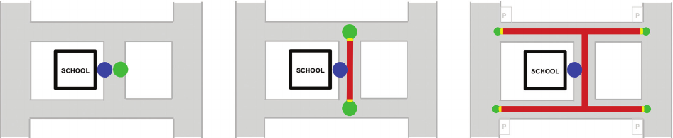
Fig. 1. The geometric intuition behind the school street closure zones (red) near the school access points (blue).
Increase in the number of drop-off nodes (green) reduces the related traffic problems and enhances safety
(elaborated by T. Dzieduszyński, O. Czeranowska-Panufnik)
Il. 1. Geometryczna intuicja stojąca za strefami zamknięcia ulic szkolnych (czerwone linie) w pobliżu punktów dostępu do szkoły (niebieskie punkty).
Zwiększenie liczby punktów wysiadania z pojazdu (zielone punkty) zmniejsza związane z tym problemy komunikacyjne i zwiększa bezpieczeństwo
(oprac. T. Dzieduszyński, O. Czeranowska-Panufnik)

School streets implementation: A machine learning perspective 141
guard (Keaney, Tovey 2018; Grabowska, Szmigiel-Franz
2020). In many cases, the implementation of school streets
impacted many stakeholders of dierent needs and interests
(Grabowska, Szmigiel-Franz 2020). The programs required
extensive informational campaigns and personal consulta-
tions to be supplemented. Moreover, the closures often bur-
dened the inhabitants of school streets. While local residents
typically received a certain number of passes, some com-
plained about the inability to receive guests during the clo-
sures (Keaney, Tovey 2018). Additionally, these programs
heavily burdened parents, necessitating sudden changes of
routines. Some parents even questioned the necessity of the
programs and believed that the reasons for their implemen-
tation were non-existent. In one of the reviewed cases, the
way to school became perceivably more dangerous after
the implementation of a school street closure zone, since
children had to cross a large road (Keaney, Tovey 2018).
A few critics of the idea raised a claim that the problems
of chaotic parking, dangerous trac and air pollution were
not solved by the closure programs, but were just moved
to another place or caused a “wave eect” (Grabowska,
Szmigiel-Franz 2020; Lawrence, Murrell 2016). While this
could be true for incorrectly designed trac regulation or-
ders, a school street closure zone with numerous, well-de-
signed drop-o nodes would have a tendency to better dis-
tribute these issues across a broader area, thus decreasing
their severity (Fig. 1). To a large extent the mentioned prob-
lems were caused by the insucient consideration of the
contexts and available data, as well as too hermetic social
consultations. A wider implementation of data-driven tools
(such as the one proposed in this study) could potentially al-
leviate the negative eects of school street implementations
related to the lacking recognition of local urban contexts.
Machine learning perspective
Following a comprehensive review of school street
closure programs implemented between 2016 and 2022,
a prototype machine leaning context-analysis algorithm
was developed in 2023 and 2024. This algorithm was
trained on the selection of 51 successful school street pi-
lot programs identied through grey literature analysis.
During inference, the prototype uses the coordinates of
a candidate school. It then extracts the most relevant spatial
contexts from OpenStreetMap (OpenStreetMap Contribu-
tors 2024) and translates these contexts into the proposed
closure zone, together with the proposed drop-o nodes
and school access points. In its current iteration, the tool
functions as a preliminary analysis instrument, focusing
solely on readily accessible open-source urban contexts.
This approach avoids the need for additional viability and
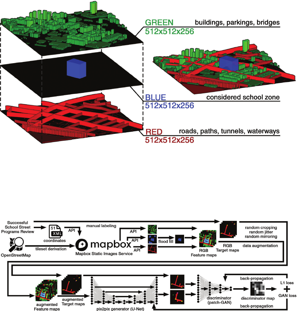
social analysis. These contexts are compiled in the form of
three voxel maps representing the urban tissue (buildings,
car parks, bridges), extents of the analysed school (school
area) and the communication network (roads, paths, tun-
nels and waterways). These maps can be represented as
a 512 × 512 RGB image, where each of the colour maps
represents one of the context groups and the intensity of
the pixel’s colour corresponds to the height of the urban
tissue and the intensity of the transit mode on the com-
munication network map (Fig. 3). One pixel represents an
area of 1.5 × 1.5 m, the extent of the context map corre-
sponds to the pedestrian shed dened by a 5-minute walk
radius, approximately 400 m (Perry 1929).
The algorithm is based on a generative adversarial neural
network (GAN) (Goodfellow et al. 2014), a type of neural
network used for generating data similar to a given dataset.
Its structure was inspired by the pix2pix architecture (Iso-
la et al. 2017). From the conducted school street programs
review, 51 the most successful examples of closure zones
were selected and RGB target maps were manually labelled.
The red channel on the target map represents the closure
zone, the green represents the drop-o node and blue rep-
resents the school access point. Coordinates of the selected
schools were compiled in an XML spreadsheet. A custom
script was used to automatically download the urban fea-
ture maps from the Mapbox Static Image Service (Mapbox
2023) through API and pair them with the hand-labelled
target maps. The training dataset was augmented through
random cropping, random jitter and random mirroring to
reduce the risk of overtting. U-Net (Ronneberger, Fischer
and Brox 2015) was used to generate the proposed school
street closure zone based on the given feature map. A patch
discriminator was applied to try to distinguish the generated
maps from the original target maps. The L1 and GAN loss
were calculated based on the algorithm’s performance and
Fig. 2. The ratio of successful
school street implementations
to failed ones based on the grey
literature analysis
(elaborated by T. Dzieduszyński,
O. Czeranowska-Panufnik)
Il. 2. Stosunek udanych wdrożeń
programów zamknięcia ulic
szkolnych do nieudanych,
na podstawie analizy
literatury szarej
(oprac. T. Dzieduszyński,
O. Czeranowska-Panufnik)
142 Tomasz Dzieduszyński, Olga Czeranowska-Panufnik
fully generated meaningful school street closure zones in
90% of validation cases (Fig. 5). The inference time on
a mid-range consumer laptop ts in the range of 1–3 s,
which allows for automated batch-processing of large sets
of candidate schools.
Case study
In this section, we provide detailed examples of the
al gorithm applied to real-world scenarios, specically in
Warsaw’s Elementary School No. 195 and No. 175. By ad-
justing road class parameters and rerunning the algorithm,
we explored dierent closure scenarios for these schools.
back-propagation was used to train both of the networks in
an ensemble (Fig. 4). Hyperparameters were tuned using
the random search method. The lambda hyperparameter
was tuned during training, increasing the weight of the L1
loss function in the later phases of training. The algorithm
was trained for 31 hours on Nvidia GF RTX 2080 Super.
During inference only the generator is used.
The developed algorithm was tested on the selection
of candidate schools for the Warsaw “Droga na szóstkę”
school street viability evaluation program (LPW 2020), as
well as four negatively assessed schools described in the
analysed pilot reviews. These schools were not included
in the training data. The trained neural network success-
Fig. 3. The context map represented as an RGB image. The green channel represents the height of the urban tissue,
blue channel represents the extents of the analysed school land, the red channel represents the intensity of the communication network.
The map is extracted from OpenStreetMap (OpenStreetMap Contributors 2024) through Mapbox Static Images Service (Mapbox 2023)
(elaborated by T. Dzieduszyński, O. Czeranowska-Panufnik)
Il. 3. Mapa kontekstów przedstawiona jako obraz RGB. Kanał zielony reprezentuje wysokość tkanki urbanistycznej,
kanał niebieski przedstawia zasięg terenu analizowanej szkoły, a kanał czerwony intensywność sieci komunikacyjnej.
Mapa została pozyskana z OpenStreetMap (OpenStreetMap Contributors) za pośrednictwem usługi Mapbox Static Images (Mapbox 2023)
(oprac. T. Dzieduszyński, O. Czeranowska-Panufnik)
Fig. 4. The training diagram of the utilized generative adversarial neural network (elaborated by T. Dzieduszyński, O. Czeranowska-Panufnik)
Il. 4. Diagram przedstawiający proces treningu zastosowanej generatywnej sieci przeciwstawnej GAN
(oprac. T. Dzieduszyński, O. Czeranowska-Panufnik)
School streets implementation: A machine learning perspective 143
The main purpose of the developed tool is the facilita-
tion of the school street selection process. The algorithm
receives the coordinates of the queried school, extracts the
urban contexts and in a few seconds, it outputs the pro-
posed school street closure zone. The generated proposal
can be used to assess the sensibility of the closure zone im-
plementation and can be later used as a baseline during the
later stages of evaluation and design process. The second
use case is the urban redesign analysis. The input feature
maps do not have to correspond to the current urban con-
texts, but can represent the planned urban interventions.
These interventions could relate to road classes, number
of car parks, redesign of the urban tissue, changes in pe-
destrian paths network or change in development intensity.
The varying input feature maps result in dierent target
maps generated by the algorithm and can help urban de-
signers better understand the relationships between school
streets and their surroundings. This use case was tested
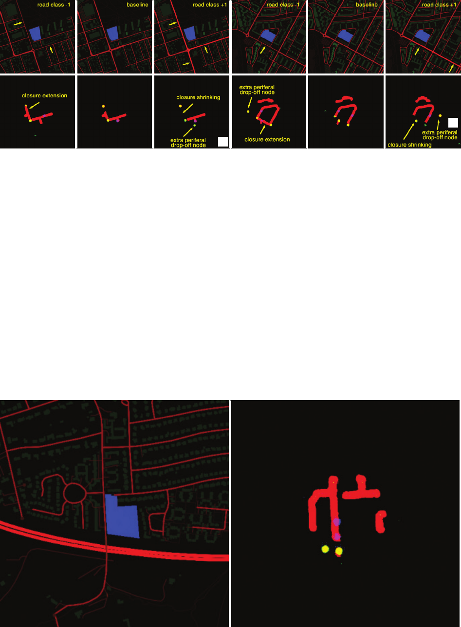
and demonstrated on the example of changing road classes
surrounding the Warsaw Elementary School No. 195 and
No. 175. Lowering the class of the road results in the ex-
tension of the possible closure zone, while increasing the
class leads to its reduction. To compensate for the shrink-
ing of the school street, the algorithm generates additional
peripheral drop-o nodes, thereby enhancing the ecien-
cy of the closure program (Fig. 6).
The results demonstrate the adaptability of the tool in
urban design. For example, lowering the road class sur-
rounding Elementary School No. 195 signicantly expand-
ed the closure zone, while increasing the road class around
No. 175 led to more distributed peripheral drop-o nodes.
These applications demonstrate how changes in urban fea-
tures aect the overall design, providing a exible solution
for urban planners.
Discussion
As demonstrated, the system can propose meaningful
school closure zones. This can be benecial during the
selection process of school street candidates and can be
utilized during urban redesign analysis. Although the re-
sults are promising, the developed tool is currently only
a prototype and it has many limitations, which reduce its
practical applicability in urban planning. One of the key
limitations is that the tool does not fully reect the com-
plexity of the school street selection process. It does not
account for important social contexts, such as stakehold-
er dynamics, local policies or preferences of students and
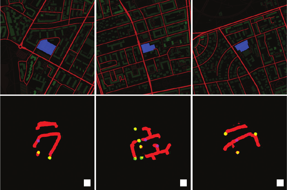
Fig. 5. School street closure zones generated by the trained algorithm for the three Warsaw candidates for the school street closure program (LPW 2020):
a) Elementary School No. 175, b) Elementary School No. 157, c) Elementary School No. 373.
Red channel of the target space represents the closure zone, green the drop-off nodes and blue the school access point
(elaborated by T. Dzieduszyński, O. Czeranowska-Panufnik)
Il. 5. Strefy zamknięcia ulic szkolnych wygenerowane przez wytrenowany algorytm dla trzech warszawskich kandydatów
do programu ulic szkolnych (LPW 2020): a) Szkoła Podstawowa nr 175, b) Szkoła Podstawowa nr 157, c) Szkoła Podstawowa nr 373.
Kanał czerwony przestrzeni celu przedstawia strefę zamknięcia, zielony – punkty wysiadania z pojazdu, a niebieski punkt dostępu do szkoły
(oprac. T. Dzieduszyński, O. Czeranowska-Panufnik)
a b c
144 Tomasz Dzieduszyński, Olga Czeranowska-Panufnik
their families. These factors play a signicant role in the
successful implementation of school street closures, and
their absence in the model reduces the sensitivity of the
tool to such nuances. It is important to note that the tool
was not developed to replace the complex urban analyses
required for these projects but to complement them by pro-
viding an additional layer of analysis that makes the design
process more context-sensitive.
The proposals generated by the neural network were
some times hard to interpret. By machine learning standards,
the training sample was very small, consisting of only
51
successful training examples represented in the reviewed
literature. This problem was partially mitigated by data
augmentation, but overall, the small training sample signi-
cantly reduced the algorithm’s generalizability, as it could
not encounter many context scenarios during the training.
Such case can be visualized on the example of the Bonaly
Primary School in Edinburgh, which closely neighbours
the Edinburgh highway bypass. Since this specic situation
was not represented in the training set, the algorithm de-
cided to generate the drop-o points in the middle of the
highway (Fig. 7).
Fig. 6. Utilization of the trained neural network in urban redesign analysis demonstrated on:
a) Warsaw Elementary School No. 195, b) Warsaw Elementary School No. 175.
Changes in road classes affect the proposed school street closure zones (elaborated by T. Dzieduszyński, O. Czeranowska-Panufnik)
Il. 6. Wykorzystanie wytrenowanej sieci neuronowej w analizie przekształceń urbanistycznych pokazane na przykładach:
a) warszawskiej Szkoły Podstawowej nr 195, b) warszawskiej Szkoły Podstawowej nr 175.
Zmiany w klasach dróg wpływają na proponowane strefy zamknięcia ulic szkolnych (oprac. T. Dzieduszyński, O. Czeranowska-Panufnik)
Fig. 7. An example of an incorrect school street closure program proposed by the algorithm for the Bonaly Primary School
resulting from the small training sample. The algorithm generated the drop-off nodes in the middle of a highway
(elaborated by T. Dzieduszyński, O. Czeranowska-Panufnik)
Il. 7. Przykład nieprawidłowego programu zamknięcia ulicy szkolnej zaproponowanego przez algorytm dla Szkoły Podstawowej Bonaly,
wynikający z niewielkiej próbki treningowej. Algorytm wygenerował punkty wysiadania z pojazdu na środku autostrady
(oprac. T. Dzieduszyński, O. Czeranowska-Panufnik)
a
b
School streets implementation: A machine learning perspective 145
References
880 Cities. School Streets Guidebook. City of Victoria, Capital Regional
District of British Columbia, 2019.
Brand, Lasse, Susanne Böhler, and Siegfried Rupprecht. Topic Guide:
Sustainable Urban Mobility Planning in Smaller Cities and Towns.
Rupprecht Consult, 2021.
Bridges, Christina N., Tyler M. Prochnow, Emily C. Wilkins, Ke shia
M. Pollack Porter, and M. Renée Umstattd Meyer. “Examin-
ing the Implementation of Play Streets: A Systematic Review of
the Grey Literature.” Journal of Public Health Management and
Practice 26, no. 3 (2020): E1–E10. https://doi.org/10.1097/PHH.
0000000000001015.
City of Edinburgh Council. “Streets Ahead, Road Safety in Edinburgh.
School Streets.” Accessed April 10, 2020, at https://www.streetsa-
headedinburgh.org.uk/school-streets-1/school-streets.
City of Victoria. “School Streets. The School Streets program creates
safer school zones and encourages active transportation.” City of
Vic toria. 2022. Accessed April 10, 2022, at https://www.victoria. ca/ -
EN/main/residents/streets-transportation/walk-roll-transit/school-
programs/school-streets.html.
Clarivate. Web of Science. n.d. Accessed April 10, 2024, at https://www.
webofscience.com/wos/woscc/summary/6d7384cd-379f-477d-
9581-eb2df65998e9-e194a1f6/relevance/1.
Clarke, Richard. School streets: Putting children and the planet rst.
Child Health Initiative’s Advocacy Hub, FIA Foundation, 2022.
Davis, Adrian. School Street Closures and Trac Displacement Project:
A Literature Review with semi-structured interviews. Transport Re-
search Institute, Edinburgh Napier University, 2020.
Goodfellow, Ian J., Jean Pouget-Abadie, Mehdi Mirza, et al. “Genera-
tive Adversarial Nets.” In Advances in Neural Information Process-
ing Systems (NIPS), edited by Zoubin Ghahramani, Max Welling,
Corinna Cortes, Neil D. Lawrence and Kilian Q. Weinberger. Curran
Associates, 2014.
Grabowska, Marta, and Anna Szmigiel-Franz. Szkolna ulica: Raport
z pilotażu. Biuro Zrównoważonej Mobilności Urzędu Miejskiego
Wrocławia, 2020.
Isola, Phillip, Jun-Yan Zhu, Tinghui Zhou, and Alexei A. Efros. “Image-to-
-Image Translation with Conditional Adversarial Networks.” In IEEE
Conference on Computer Vision and Pattern Recognition (CVPR),
2017, 5967–5976.
Keaney, David, and Paul Tovey. School Streets Pilot Project – Six Month
Update and Review. Report, Solihull Metropolitan Borough Coun-
cil, 2018.
Lawrence, Paul, and Steven Murrell. School Streets Pilot Project Eva
luation. Transport and Environment Committee, The City of Edin-
burgh Council, 2016.
Linton, Tyler, Doolin O’Reilly, Dominique Humbert, and Caroline Bur-
well. School Streets Timed Trac Restrictions Toolkig for Profes-
sionals. Hackney School Streets, 2021.
LPW. “Droga na szóstkę: Ocena bezpieczeństwa ruchu drogowego wo-
kół wybranych szkół podstawowych: Raport końcowy, Szkoła pod-
stawowa nr 41; 157; 175; 195; 323; 327.” Zarząd Dróg Miejskich,
Urząd m.st. Warszawy, 2020.
Mapbox. “Mapbox Studio.” Generated September 2023. Accessed Feb-
ruary 2, 2024, at https://www.mapbox.com/about/maps.
My Journey: Helping Hampshire Get Around. “Southampton School
Streets programme.” Southampton City Council. 2021. Accessed
April 10, 2022, at https://myjourneyhampshire.com/education/
school-streets/southampton-school-streets-programme/.
To some extent the failure in this case could be partial-
ly justied by the negative assessment of viability of the
Bonaly Primary School for the implementation of a school
street closure program (Lawrence, Murrell 2016). Due to
the limited training sample, the algorithm was trained to
always generate a closure zone, even if the contexts are not
favourable. This hard requirement sometimes leads to in-
correct proposals. As the tool was being developed, a large
number of school street programs were implemented as
a result of the COVID-19 pandemic (Clarke 2022). Cur-
rently, a much larger dataset of successful closures can be
compiled to train the next iteration of the algorithm. Anoth-
er large problem arises from the incompleteness of the ana-
lysed contexts and the low resolution of the accessible data.
The utilized feature maps do not fully reect the real-world
complexities of implementing school street closures. While
the tool could denitely benet from more extensive, high-
resolution data, such data is not readily available or ma-
chine-friendly. These extended contexts could include:
– trac analysis, such as the road safety audit, recorded
incidents aecting the school community and trac inten-
sity measurements,
–
communication habits of the students and their parents,
– functional audit,
– database of stakeholders aected by the closure and
their characteristics,
– air quality and pollution measurements,
– records of other programs related to school street clo-
sures at the candidate school, including physical activity
encouragement projects, play streets, school gardening ini-
tiatives, local community activization, etc.
A more comprehensive data collection and integration
could improve the tool’s eectiveness and would proba-
bly increase the capabilities of the system. However, an
increase in the number of compiled context sources would
also reduce the applicability of the algorithm only to the
areas, which have these contexts recorded and accessible.
The current version of the algorithm can be applied to any
school that is represented on OpenStreetMap. Future re-
search should focus on expanding the dataset and improv-
ing the algorithm’s adaptability to diverse urban contexts.
Additionally, a collaborative approach involving stake-
holders from various sectors, including education, trans-
portation, and public health, is crucial for the successful
implementation and scaling of school street programs. By
doing so, cities can create safer, healthier and more vibrant
urban spaces that prioritize the well-being of children and
the entire urban community.
Conclusions
In conclusion, this study demonstrates the potential of
data-driven approaches to enhance the planning and im-
plementation of school street programs. The integration of
machine learning tools can streamline the selection pro-
cess and improve the design of these interventions, making
them more eective and context-sensitive. Policymakers
and urban planners should consider investing in the de-
velopment and deployment of such tools to support their
urban mobility goals.
146 Tomasz Dzieduszyński, Olga Czeranowska-Panufnik
Noble, Ruth, Naomi Boal, Chelle Watson, Emily Jackson, and Jack Po-
well. School Streets Intervention Sites vs. Control Sites Full Report.
Transport for London, 2021. Accessed June 20, 2022, at https://con-
tent.t.gov.uk/school-streets-evaluation-report-website.pdf
OpenStreetMap Contributors. “OpenStreetMap.” 2024. Accessed Janu-
ary 5, 2024, at https://www.openstreetmap.org/.
Perry, Clarence Arthur. “The Neighborhood Unit, a Scheme of Ar-
rangement for the Family-Life Community.” In Neighborhood and
Community Planning, Regional Plan of New York and Its Environs,
edited by Thomas Adams, Robert W. de Forest, John H. Finley
et al. Committee on Regional Plan of New York and Its Environs,
1929.
Perth and Kinross Council. “School Exclusion Zones.” Accessed June 20,
2022, at https://www.pkc.gov.uk/article/17611/School-exclusion-zones.
Pressl, Robert. “Bolzano: School Streets.” Eltis Mobility Portal. 2011.
Video, 5 min, 2 sec. Accessed April 2022. https://www.youtube.com/ -
watch?v=j8xKUjzaK8c.
Reeves, Will R. “Report of Committee on Street Play.” The Journal of
Educational Sociology 4, no. 10 (1931): 607–18.
Ritchie, Cameron. “Four More East Lothian Schools Set to Ban Trac from
Nearby Streets at Pick-up and Drop-o Times.” East Lothian Courier,
January 18, 2016. https://www.eastlothiancourier.com/news/14211155.
four-more-east-lothian-schools-set-to-ban-trac-from-nearby-streets-
at-pick-up-and-drop-o-times/.
Ronneberger, Olaf, Philipp Fischer, and Thomas Brox. “U-Net: Convolu-
tional Networks for Biomedical Image Segmentation.” In Medical Im-
age Computing and ComputerAssisted Intervention – MICCAI 2015.
Lecture Notes in Computer Science, edited by Nassir Navab, Joachim
Hornegger, William M. Wells and Alejandro F. Frangi. Vol. 9351.
Springer, 2015. https://doi.org/10.1007/978-3-319-24574-4_28.
School Street Initiative. “What Are School Streets.” Published January,
2019. Accessed April 10, 2022, at http://schoolstreets.org.uk/.
Solihull Metropolitan Borough Council. “Solihull School Streets.” Ac-
cessed April 10, 2021, at https://www.solihull.gov.uk/Roads-pave-
ments-and-streetcare/Solihull-school-streets.
Stubbs, Alan. “School Streets – Trac Prohibition TROs” – An Assess-
ment Policy.” East Lothian Council, 2016. Accessed April 10, 2022,
at https://www.eastlothian.gov.uk/download/meetings/id/17220/04_
school_streets_trac_prohibition_tros_an_assessment_policy.
Urząd m.st. Warszawy. Bezpieczniej w drodze do szkoły. Startują kolejne
“Szkolne ulice.” Published September 20, 2022. Accessed Novem-
ber 12, 2022, at https://um.warszawa.pl/waw/strategia/-/startuja-
kolejne-szkolne-ulice.
Zarząd Dróg Miejskich [Warszawa]. “Droga na Szóstkę. Program po-
prawy bezpieczeństwa w okolicach szkół. Edycja I. Podsumowa-
nie audytów.” Published June 9, 2021. Accessed April 10, 2022, at
https://zdm.waw.pl/wp-content/uploads/2021/06/Droga-na-6_pod-
sumowanie_szczegolowe.pdf.
Streszczenie
Wprowadzanie ulic szkolnych: perspektywa uczenia maszynowego
Tematem artykułu są ulice szkolne, a zwłaszcza proces ich tworzenia z perspektywy uczenia maszynowego. Autorzy przedstawili w nim możli-
wości zastosowania generatywnych sieci przeciwstawnych typu GAN we wdrażaniu koncepcji zamknięcia ulic szkolnych, której celem jest poprawa
bezpieczeństwa i zmniejszenie natężenia ruchu wokół szkół. Przeanalizowali programy ulic szkolnych na całym świecie, identykując powtarzające
się wyzwania i proponując rozwiązania. Na podstawie analizy 51 skutecznych wdrożeń oraz nowej metody ekstrakcji cech miejskich opracowali
model uczenia maszynowego, który wspomaga wybór potencjalnych lokalizacji ulic szkolnych. Tak przygotowane narzędzie ma służyć usprawnie-
niu procesu wyboru i zwiększeniu efektywności projektu przez lepsze dopasowanie do lokalnego kontekstu. Pomimo pewnych ograniczeń, takich
jak trudność w odwzorowaniu wszystkich kontekstów przestrzennych, system dostarcza wartościowych wniosków dotyczących regulacji ruchu
miejskiego. Badanie wypełnia lukę w literaturze naukowej i oferuje podejście oparte na danych do projektowania bezpieczniejszych przestrzeni
miejskich.
Słowa kluczowe: ulice szkolne, uczenie maszynowe, smart city, generatywne sieci przeciwstawne, projektowanie architektoniczne wspomagane
komputerowo