
2025
4(84)
Maciej Pilny*
Urban densification in local spatial development plans:
a case study of Wrocław city centre between 2010 and 2024
DOI: 10.37190/arc250413
Published in open access. CC BY NC ND license
Abstract
The background of the research conducted for this article is the increasing activity of real estate developers in the centres of Polish cities in recent
years. Wrocław was chosen as one of the fastest-developing cities in Poland. The aim of the study was to identify the approach of planning authorities
to urban densication in the provisions of local spatial development plans adopted between 2010 and 2024. The research included an analysis of 95
local spatial development plans with regard to the urban density indicators contained in them.
Based on an analysis of planning activity in the city centre of Wrocław between 2010 and 2024, the extent to which the process of urban den-
sication is planned and controlled – on the basis of binding local spatial development plans – was determined. The study revealed that local plans
are used both to establish a framework for the densication of the built environment and to prevent undesirable densication. Urban densication
strategies present in the planning documents were identied. As a result of the analysis, an original classication of local plans into four categories
was proposed, each reecting a dierent approach to the densication process.
Key words: urban planning, spatial planning, Wrocław, densication
Introduction
The starting point for this research is the intensied activ-
ity in recent years of developers delivering residential proj-
ects within already urbanised areas, especially in Poland’s
largest cities (Samorek, Cichocki 2023). New investments
are frequently located in areas with an already dened ur-
ban fabric (e.g. within prefabricated-panel housing estates
or as frontage completion) or on post-industrial land. They
are often criticised for the low quality of both the buildings
and their surroundings, for high population densities, and
for the deterioration of living conditions in densied estates.
The colloquial term patodeweloperka
1
– a pejorative neolo-
gism targeting poor-quality housing – has entered common
* ORCID: 0000-0002-6634-7475. Faculty of Architecture, Wro-
cław University of Science and Technology, Poland, e-mail: maciej.
pilny@pwr.edu.pl
1
This term has, for instance, appeared in the titles of books by Łu-
kasz Drozda (Dziury w ziemi. Patodeweloperka w Polsce. Czarne, 2023)
and Bartosz Józeak (Patodeweloperka. To nie jest kraj do mieszkania.
Znak Literanova, 2024).
Polish usage as a pointed expression of this critique. The
prevalence of negative opinions about residential schemes
in Polish cities raises the question of the extent to which
densication is a planned process rather than a spontaneous
one. At the same time, the public debate includes both argu-
ments in favour of densication as a path to more sustain-
able development and objections to densication as a driver
of declining urban quality and overburdened infrastructure
(Arnberger 2012; Berghauser Pont et al. 2021).
Another salient thread in the discussion concerns the
impact of densication on the urban microclimate and the
formation of urban heat islands. Research has shown that
urbanisation raises air temperatures locally, and that mean
temperatures change more rapidly in areas undergoing ur-
banisation than elsewhere within the same city (Rozbicki
et al. 2020). This stems from increasing hard surfaces at the
expense of permeable and vegetated ones (Rinner, Hussain
2011). Under certain conditions, however, densication
can produce “cool islands” and cool street canyons through
increased shading (Vuckovic et al. 2019). These examples
underscore that urban densication and the various ways
it is pursued cannot be judged unambiguously as neg-

140 Maciej Pilny
ative or positive; its eects on urban quality are context-
dependent.
During the study period – prior to the introduction of
general plans into Poland’s spatial planning system – the
key local instrument shaping spatial policy was the Local
Spatial Development Plan (LSDP) (Nowakowski 2013).
Unlike the municipality’s higher-level Study of Conditions
and Directions of Spatial Development, LSDPs are local
legal acts and provide the binding basis for development
on the land they cover. By law, LSDPs must specify rules
for shaping development, including the maximum building
coverage ratio permitted on each site and the maximum
building height. Consequently, the content of LSDPs eec-
tively decides whether densication is possible in urbanised
areas and sets its bounds. Current regulations also allow de-
velopment on land not covered by an LSDP. Even so, plans
adopted for inner-city areas are a suitable source material
for examining how local authorities approach densifying the
urban fabric and how they regulate that process.
Description of own research
Aim and scope of the study
The purpose of the study is to establish how LSDPs shape
the development of inner-city areas with respect to densi-
cation by new residential buildings. The intermediate aims
are: to compare the maximum density indicators permitted in
LSDPs with the pre-plan state on the same land and to iden-
tify and categorise dierent densication strategies encoded
in the plans.
The temporal scope is 2010–2024. The start date corre-
sponds to a signicant amendment to the Study of Conditions
and Directions of Spatial Development of Wrocław (Uch wa-
ła Rady Miej skiej Wrocławia 2010) originally adopted in
1998. The end date is 2024, when preparations were under-
way to implement an amendment to the Spatial Planning and
Development Act introducing the general plan
2
which has
to replace the Study of Conditions… The territorial scope
is Wrocław’s city centre, delineated in the graphic annex
to the 2018 version of the Study of Conditions… (Uchwała
Rady Miejskiej Wrocławia 2018). The subject scope covers
analysis of the textual and graphic parts of LSDPs adopted
in the period. The research corpus comprises 95 LSDPs.
Methods
The study analyses the graphic and textual provisions of
LSDPs adopted in 2010–2024 with regard to density indica-
tors. The quantitative analysis compares the maximum oor
area ratio (FAR) specied in each plan with the pre-plan
FAR on the same land. In addition to the LSDPs themselves,
the data source was Wrocław’s Spatial Information System
2
In October 2024, Wrocław City Council adopted ve resolutions to
commence the preparation of Local Spatial Development Plans (LSDPs)
which, taken together, cover the entire area of the city not yet covered
by plans. The purpose was to forestall the need to issue decisions on
development conditions (WZ) during the transitional period while work
on the general plan was under way.
portal, which publishes annually updated orthophoto maps.
Historical satellite imagery was used to determine land use
prior to plan adoption.
The research was extended to include a qualitative analy-
sis of Wrocław City Council resolutions initiating the prepa-
ration of LSDPs (especially their explanatory memoranda)
and selected Council session minutes where these legal
acts were discussed. The aim of the qualitative analysis is
to identify the motivations for covering specic areas with
LSDPs.
Degree of coverage
of the study area by LSDPs
The study covers Wrocław’s city-centre area in borders
dened in the Study of Conditions… For analytical clari-
ty, it was divided according to the Study’s system of urban
units. Areas designated in the land-use drawing as indus trial,
service, green, or restricted were excluded. Adjacent urban
units with similar morphology were combined, yielding
eight research sectors: S1 – Stare Miasto; S2 – Śródmieście
Nadodrzańskie and Plac Grunwaldzki; S3 – Przedmieś-
cie Świdnickie and Oławskie; S4 – Kępa Mieszczańska;
S5 – Kle czków; S6 – Huby; S7 – Przedmieście Południowe
and Grabiszyn; S8 – Szczepin and Popowice.
By the end of 2024, LSDPs covered 52.7% of the city-
centre area; in 2010–2024, newly adopted LSDPs covered
848.05 ha, or 26.7% of the centre. Coverage was highest
in S4 – Kępa Mieszczańska (100.0%), S1 – Stare Miasto
(99.0%) and S5 – Kleczków (72.7%). These sectors also
saw the largest shares of land covered by plans adopted in
the study period – 51.5% (S4), 43.7% (S1) and 31.3% (S3)
– indicating strong local-authority interest in regulating de-
velopment on these areas.
Selection of indicators for measuring density
in LSDPs
Urban density can be captured by many indicators, most
of which fall into two groups: those based on population
and those based on the physical parameters of development
(Dovey, Pafka 2014). Density can also be measured at var-
ious scales – from the building and plot through ensem-
bles and districts to the citywide scale (Angel et al. 2021).
Commonly used metrics include population density (Cheng
2009), building coverage ratio (BCR), average weighted
num ber of storeys, oor area ratio (FAR) (Bradecki 2021),
and residential density (Wyżykowski 1973; Michalski 2010).
Given the nature and scope of LSDPs, this study relies on
physical-parameter indicators.
Under the current Spatial Planning and Development Act
(Ustawa o planowaniu i zagospodarowaniu przestrzen nym
2003), LSDPs must, among other things, dene maxi mum
above-ground FAR and the maximum share of site area that
may be occupied by buildings (BCR). The analysis did not
rely solely on the values specied in the textual part of the
plans but confronted them with the actual development ca-
pacity arising from building lines in the graphic part and
from existing buildings. FAR was estimated from the max-
imum permissible building footprint and height. Average
Urban densication in local spatial development plans: a case study of Wrocław city centre between 2010 and 2024 141
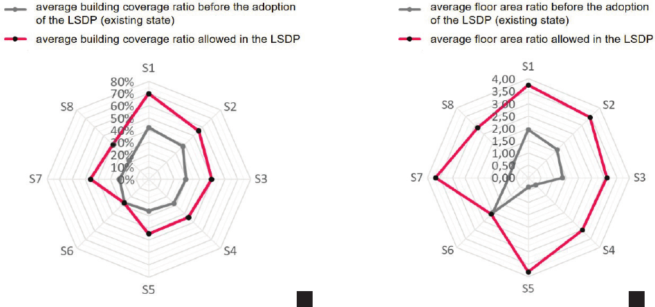
FARs for these uses ranged from 2.02 to 4.08 across sectors,
with a mean of 2.90 (versus a baseline of 1.13). Based on the
average BCR and FAR gures, the mean permitted height
of multi-family residential development in Wrocław’s city
centre can be estimated at 7.02 storeys. These data indicate
a clear planning intention to increase development density
in the city centre.
Comparing indicators by sector reveals diering densi-
cation strategies. The highest permitted residential FARs
occur in the morphologically contrasting S7 – Przedmieś-
cie Południowe and Grabiszyn (4.08) and S1 – Stare Mia-
sto (3.80). Despite similar FARs, the permitted residential
BCRs dier markedly – 70.4% in S1 versus 42.5% in S7.
In the historic core, the preference is thus for a higher BCR
combined with limits on building height. In the ring around
the centre – especially on post-industrial land where entirely
new residential ensembles can emerge – taller buildings are
allowed while retaining a relatively larger share of undevel-
oped land, notably green areas.
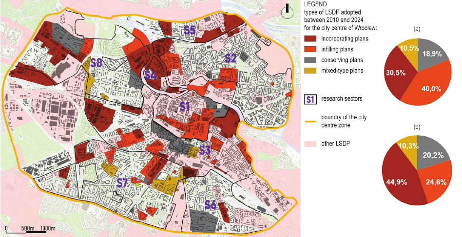
Four approaches to densification
in Local Spatial Development Plans
The ndings support a classication of LSDPs accord-
ing to their approach to densifying development. Four plan
types – conserving, inlling, incorporating and transform-
ing – were identied.
Conserving plans either prohibit or strictly limit new de-
velopment within the plan area. Their aim is to protect the
existing urban composition, scale and density. Examples in-
clude plans for 1970s estates along Śliczna and Gwiaź dzista
streets. These were justied by the need to counter uncon-
trolled inll – often in response to rising numbers of devel-
opment conditions applications under heightened investment
storey height was assumed at 2.9 m for residential and 3.4 m
for service buildings.
Analysis of changes in urban density indicators
in Local Spatial Development Plans
Across all sectors, the adopted LSDPs enabled an in-
crease in both BCR and FAR relative to the pre-plan con-
dition.
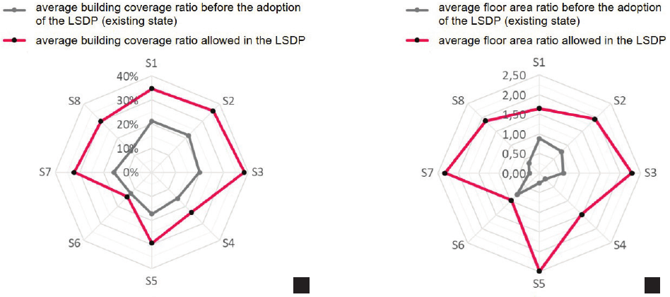
In most sectors, the average BCR permitted by the plans
ranged from 25% to 40%, with a mean of 29.4% across all
sectors (Fig. 1). This represents an average increase of 12.9
percentage points over the existing BCR (16.5%). The high-
est BCRs were permitted in the most central sectors – S1
– Stare Miasto; S2 – Śródmieście Nadodrzańskie and Plac
Grunwaldzki; S3 – Przedmieście Świdnickie and Oławskie
– which share a pre-20
th
-century morphological type domi-
nated by compact perimeter blocks of multi-family housing
and services.
LSDPs also enabled higher FARs. Prior to plan adop-
tion, the mean FAR on the study areas was 0.60, while
average maximum FARs permitted across sectors ranged
from 1.02 to 2.35, with a cross-sector mean of 1.84. The
sectors dominating in terms of FAR are those surrounding
the historic core: S2 – Śródmieście Nadodrzańskie and Plac
Grunwaldzki; S3 – Przedmieście Świdnickie and Oławskie;
S7 – Przedmieście Południowe and Grabiszyn.
A separate analysis focused on areas designated in LSDPs
for multi-family residential use (MW) and mixed residen-
tial-service use (MW-U, U-MW). In these areas, maximum
permitted BCRs across sectors ranged from circa 30% to
circa 70%, with a mean of 41.3% across all sectors (Fig. 2).
This implies an average increase of 17.0 percentage points
compared to the existing BCR (24.3%). Average permitted
Fig. 1. Radar charts showing the average building coverage ratio (a) and floor area ratio (b) in a given area prior to the adoption of LSDP,
and the average maximum parameters permitted in local plans adopted between 2010 and 2024 for the individual research sectors
(elaborated by M. Pilny)
Il. 1. Wykresy radarowe przedstawiające średni wskaźnik powierzchni zabudowy (a) i intensywności zabudowy (b) na danym terenie
przed przyjęciem MPZP i średnie maksymalne parametry dopuszczone w planach miejscowych przyjętych w latach 2010–2024
dla poszczególnych sektorów badawczych (oprac. M. Pilny)
a b
142 Maciej Pilny
The distributions and locations shown in Figure 3 indi-
cate several clear tendencies in Wrocław’s planning prac-
tice. First, there is a drive to ll gaps in areas with a clearly
dened urban fabric, as in S1 – Stare Miasto. Simultane-
ously, some existing housing estates are protected against
densication. This is especially visible in 1970s and 1980s
estates, where relatively large undeveloped areas could ac-
commodate new projects (Szafrańska 2013), albeit often
at the expense of spatial quality, residents’ access to green
space, or parking (Dąbrowski, Pilny 2021). Another strong
tendency is the incorporation of former industrial and rail-
way areas into the functional urban core by changing their
designation to mixed residential-service uses.
Conclusions
The results indicate that, in 2010–2024, densifying the
central part of Wrocław was an important objective of local
regulation. The authorities responsible for shaping the city’s
spatial policy drafted and adopted LSDPs whose provisions
explicitly addressed the densication of the urban fabric.
Motivations related to densication frequently appeared in
the explanatory memoranda accompanying resolutions to
commence the preparation of LSDPs. These memoranda
often referred to the intention to respond to pressure from
real estate developers investing in Wrocław’s centre and to
the need to bring order to this process. At the same time,
some local plans were intended to prevent densication of
particular areas. Overall, the city’s densication policy was
largely reactive, responding to ongoing investors activity
and growing market pressure to build on city centre land.
In many cases, plan-making followed opposition from local
communities to new development, especially on green land.
pressure. A hallmark of conserving plans is that permitted
density indicators are maintained at or close to existing levels.
Inlling plans set conditions for lling gaps within an
already clearly dened urban structure that nonetheless re-
quires completion. They typically enable a moderate increase
in FAR relative to existing conditions, and the permitted pa-
rameters mirror those of the surrounding buildings.
Incorporating plans change the function of the plan area
and are often linked to the conversion of sites losing their
previous purpose. Densication is usually achieved by
transforming industrial or low-intensity service land into
high-intensity residential or mixed residential-service land.
The essence of these plans is to incorporate formerly sep-
arate or mono-functional areas – such as post-industrial or
railway sites – into the city’s multifunctional core. They are
characterised by signicant increases in both BCR and FAR
relative to the pre-plan state and by the introduction of an en-
tirely new urban fabric based on a new urban composition.
To complete the typology, a fourth type – transforming
plans – is included, even though none were identied in the
analysed set; they were present in older plans. These con-
cern already built-up residential or mixed residential-service
areas, yet contain provisions aimed at reorganising the urban
composition by replacing existing structures with new de-
velopment or by adding to them in ways that substantially
alter the spatial layout. Transforming plans may increase,
decrease or maintain density indicators at levels similar to
the current condition.
Of the 95 LSDPs analysed, 38.9% were inlling plans,
31.6% incorporating plans, and 18.9% conserving plans
(Fig. 3). By land area covered, incorporating plans account-
ed for 44.9%, inlling plans for 24.6%, and conserving plans
for 20.2% (Fig. 3).
Fig. 2. Radar charts showing the average building coverage ratio (a) and floor area ratio (b) in a given area prior to the adoption of LSDP,
as well as the average maximum parameters permitted in local plans adopted between 2010 and 2024 for areas designated
for multi-family residential and mixed residential-service functions (elaborated by M. Pilny)
Il. 2. Wykresy radarowe przedstawiające średni wskaźnik powierzchni zabudowy (a) i intensywności zabudowy (b) na danym terenie
przed przyjęciem MPZP i średnie maksymalne parametry dopuszczone w planach miejscowych przyjętych w latach 2010–2024
dla obszarów przeznaczonych pod funkcję mieszkaniową wielorodzinną i mieszkaniowo-usługową (oprac. M. Pilny)
a b
Urban densication in local spatial development plans: a case study of Wrocław city centre between 2010 and 2024 143
The analysed LSDPs reveal dierent strategies for densi-
fying the city centre. The local authority sought to regulate
densication both through gap-site building within already
developed areas (inlling plans) and by incorporating new
areas – mainly post-industrial – into the city’s multifunc-
tional core (incorporating plans). There are also cases where
densication was treated as undesirable and LSDPs were
used to protect the existing state of development (conserv-
ing plans). No plans were found whose provisions would
bring about a comprehensive reorganisation of existing res-
idential areas (transforming plans).
The identied LSDP types correspond, to some extent,
with Michael R.G. Conzen’s (1982) four phases of the urban
development cycle (initiation, inlling, saturation and re-
duction) and with Marek Koter’s (2015) three processes
aecting morphological units or systems: inlling, supple-
menting and transformation. According to Koter, these in-
volve, respectively, adding elements to existing units, creat-
ing new units and reconstructing existing spatial structures.
In the author’s view, that terminology is only partially ap-
plicable to the typology of local plans; hence the dierent
labels for LSDP types proposed in this article.
Planned densication is evident in LSDPs adopted for
areas of diering morphological types. Strategies vary with
local conditions – historical context, morphology and degree
of development. Wrocław’s internal growth has primarily
proceeded along two lines: (i) converting post-industrial
land to residential and mixed uses and (ii) complementing
the historic fabric with gap-site inll. Some LSDPs, by con-
trast, protect against densication – especially within the
historic urban fabric and in already densely populated large
housing estates (e.g., Huby, Popowice, Szczepin). For these
Fig. 3. The location of individual types of LSDP adopted for Wrocław’s city centre between 2010 and 2024 with pie charts showing
the share of each type in terms of: a) the number of adopted plans, b) the area covered by the plans (elaborated by M. Pilny)
Il. 3. Lokalizacja poszczególnych typów MPZP uchwalanych dla śródmieścia Wrocławia w latach 2010–2024 oraz diagramy kołowe
przedstawiające udział poszczególnych typów, biorąc pod uwagę: a) liczbę uchwalonych planów, b) powierzchnię terenu objętego planami
(oprac. M. Pilny)
estates, two strategies were employed concurrently: protect-
ing inter-block green space from inll and actively building
out sites reserved in the original estate designs for service
facilities. Such densication can functionally complete es-
tates and foster a more varied and liveable urban environ-
ment (Jacobs 2014), provided that the new architecture is
not mono-functional and improves residents’ access to di-
verse functions (Sim 2019).
An increase in urban-density indicators was present in the
analysed LSDPs across all research sectors. The highest val-
ues of BCR occurred in the central part of the city, where the
historic urban fabric has been preserved, while the highest
values of FAR were found in the ring surrounding the his-
toric centre, where LSDPs typically allow taller buildings.
In the author’s assessment, spatial context played a decisive
role in shaping these indicators. The planning intention was
to protect the urban composition of the historic core, where-
as in places where the historical context was less strong, tall-
er buildings were permitted while reserving more open land.
In the study period, Wrocław’s authorities clearly sought
to establish a planning framework for densifying the in-
ner-city with residential development. This process was
driven primarily by rising housing demand – visible in all
major Polish cities – and by revived investment activity in
the housing market. This is evidenced, for example, by the
adoption of plan amendments introducing residential uses
on land previously designated for services. The analysis of
density indicators in the examined LSDPs shows that mu-
nicipal policy followed market trends by permitting proj-
ects with parameters markedly higher than those of nearby
existing buildings. The adopted LSDP provisions therefore,
to a signicant extent, prioritised densication – even at the
144 Maciej Pilny
References
Angel, Shlomo, Patrick Lamson-Hall, and Zeltia Gonzalez Blanco.
“Anatomy of Density: Measurable Factors That Constitute Urban
Density.” Buildings and Cities 2, no. 1 (2021): 264–82. https://doi.
org/10.5334/bc.91.
Arnberger, Arne. “Urban Densication and Recreational Quality of Pub-
lic Urban Green Spaces – a Viennese Case Study.” Sustainability 4,
no. 4 (2012): 703–20. https://doi.org/10.3390/su4040703.
Berghauser Pont, Meta, Per Haupt, Per Berg, Victoria Alstade, and Axel
Heyman. “Systematic Review and Comparison of Densication Ef-
fects and Planning Motivations.” Buildings and Cities 2, no. 1 (2021):
378–401. https://doi.org/10.5334/bc.125.
Bradecki, Tomasz. Wskaźniki, parametry i modele w kształtowaniu in-
tensywnej wielorodzinnej zabudowy mieszkaniowej. Wydawnictwo
Politechniki Śląskiej, 2021.
Cheng, Vicky. “Understanding Density and High Density.” In Designing
High-Density Cities. For Social and Environmental Sustainability,
edited by Edward Ng. Taylor and Francis, 2009.
Conzen, Michael R.G. “The Plan Analysis of an English City Centre.”
In Proceedings of the IGU Symposium in Urban Geography, Lund
1960, edited by Knut Norborg. C.W.K. Gleerup, 1962.
Dąbrowski, Kamil, and Maciej Pilny. “Nowi na osiedlu – wpływ do-
gęszczania zabudowy na życie w osiedlach z wielkiej płyty.” Rzut,
28 (2021): 70–9.
Dovey, Kim, and Elek Pafka. “The Urban Density Assemblage: Mod-
elling Multiple Measures.” Urban Design International 19 (2014):
66–76. https://doi.org/10.1057/udi.2013.13.
Jacobs, Jane. Śmierć i życie wielkich miast Ameryki. Translated by
Łukasz Mojsak. Fundacja Centrum Architektury, 2014.
Koter, Marek. Geograa historyczna i polityczna w badaniach Marka
Kotera. Wybór prac. Wydawnictwo Uniwersytetu Łódzkiego, 2015.
Michalski, Marcin. “Tendencje w kształtowaniu zabudowy mieszkanio-
wej po 2004 roku na przykładzie Wrocławia.” PhD diss., Politech-
nika Wrocławska, 2010.
Nowakowski, Maciej. Sto lat planowania przestrzeni polskich miast
(1910–2010). Ocyna Naukowa, 2013.
Rinner, Claus, and Mushtaq Hussain. “Toronto’s urban heat island – explor-
ing the relationship between land use and surface temperature.” Remote
Sensing 3, no. 6 (2011): 1251–65. https://doi.org/10.3390/rs3061251.
Rozbicki, Tomasz, Małgorzata Kleniewska, Katarzyna Rozbicka, Grze-
gorz Majewski, and Dariusz Gołaszewski. “Relating urban develop-
ment and densication to temporary changes in the air temperature
in Warsaw (Poland).” Theoretical and Applied Climatology 142,
no. 3 (2020): 513–23. https://doi.org/10.1007/s00704-020-03311-3.
Samorek, Barbara, and Michał Cichocki. Polski rynek nieruchomości
mieszkaniowych. Badania Obserwatorium Polityki Miejskiej, In-
stytut Rozwoju Miast i Regionów, 2023. https://doi.org/10.51733/
opm.2023.03.
Sim, David. Soft City: Building Density for Everyday Life. Island Press,
2019.
Szafrańska, Elżbieta. “Możliwości przekształceń wielkich osiedli miesz-
kaniowych w mieście postsocjalistycznym w Polsce.” Studia Miej-
skie 11 (2013): 39–53.
“Uchwała nr L/1467/10 Rady Miejskiej Wrocławia z dnia 20 maja 2010 r.
w sprawie uchwalenia zmiany Studium uwarunkowań i kierunków
zagospodarowania przestrzennego Wrocławia.” Biuletyn Urzędowy
Rady Miejskiej Wrocławia z 2010 r. poz. 116. Published May 31,
2010. Accessed June 1, 2025, at https://baw.um.wroc.pl/UrzadMia-
staWroclawia/document/60676/Uchwa%C5%82a-L-1467-10.
“Uchwała nr L/1177/18 Rady Miejskiej Wrocławia z dnia 11 stycznia
2018 r. w sprawie uchwalenia Studium uwarunkowań i kierunków
za gospodarowania przestrzennego Wrocławia.” Biuletyn Urzędowy
Ra dy Miejskiej Wrocławia z 2018 r. poz. 5. Published January 11,
2018. Accessed June 1, 2025, at https://baw.um.wroc.pl/UrzadMiasta-
Wro clawia/document/34134/Uchwa%C5%82a-L-1177-18.
“Ustawa z dnia 27 marca 2003 r. o planowaniu i zagospodarowaniu prze-
strzennym.” Dz.U. 2003 Nr 80, poz. 717. Published March 1, 2003.
Accessed June 1, 2025, at https://isap.sejm.gov.pl/isap.nsf/DocDeta-
ils.xsp?id=wdu20030800717.
Vuckovic, Milena, Wolfgang Loibl, Tanja Tötzer, and Romana Stolln-
berger. “Potential of urban densication to mitigate the eects of
heat island in Vienna, Austria.” Environments 6, no. 7 (2019): 82.
https://doi.org/10.3390/environments6070082.
Wyżykowski, Andrzej. “Próba określenia wskaźników wartościujących
gęstości urbanistyczne osiedli mieszkaniowych.” PhD diss., Poli-
technika Krakowska, 1973.
Streszczenie
Dogęszczanie urbanistyczne w miejscowych planach zagospodarowania przestrzennego.
Przykład śródmieścia Wrocławia w latach 2010–2024
Tło przeprowadzonych na potrzeby artykułu badań stanowi rosnąca w ostatnich latach aktywność deweloperów w centrach polskich miast. Wrocław
został wybrany jako jedno z najszybciej rozwijających się miast w Polsce. Celem badania było zidentykowanie podejścia władz planistycznych do
dogęszczania urbanistycznego w zapisach miejscowych planów zagospodarowania przestrzennego uchwalanych w latach 2010–2024. Badania objęły
analizę 95 miejscowych planów zagospodarowania przestrzennego pod kątem zawartych w nich wskaźników urbanistycznych dotyczących gęstości
zabudowy – wskaźnika powierzchni zabudowy oraz wskaźnika intensywności zabudowy.
Dzięki analizie aktywności planistycznej na terenie śródmieścia Wrocławia w latach 2010–2024 określono, w jakim stopniu proces dogęszczania
tkanki miejskiej jest planowany i kontrolowany, czyli oparty na obowiązujących miejscowych planach zagospodarowania przestrzennego. Zauważono, że
plany miejscowe używane są w celu zarówno tworzenia ram dla procesu dogęszczania zabudowy, jak i zapobiegania niechcianemu dogęszczaniu. Ziden-
tykowano występujące w dokumentach strategie dogęszczania urbanistycznego. W wyniku przeprowadzonej analizy zaproponowano autorski podział
planów miejscowych na cztery kategorie, z których każdą charakteryzuje inne podejście do procesu dogęszczania.
Słowa kluczowe: planowanie przestrzenne, Wrocław, urbanistyka, dogęszczanie
expense of maintaining urban order, understood as match-
ing the parameters of new development to the existing ur-
ban context.
A constructive response to the need for harmonious de-
velopment of inner-city areas would be to investigate urban
density at the level of individual urban units and to use the
resulting data to develop local urban standards. These could
steer densication in a controlled and balanced way that
improves – rather than diminishes – the quality of life in the
dense city. Conscious policymaking on urban densication
is not possible without in-depth analysis of the indicators
that describe urban density.
