2022
4(72)
Dominika Kuśnierz-Krupa*, Kazimierz Kuśnierz**,
Małgorzata Hryniewicz***, Julia Ivashko****, Dorota Bober*****
Conservation of the Renaissance towns of Southern Poland
based on selected examples: an introduction to research
Introduction
The conservation and revalorization of historical urban
layouts appears to be a particularly signicant subject. As
a result of the dynamic development of big and small cit-
ies, as well as their multi-directional transformation, any
and all initiatives aimed at the conservation and revalori-
zation of historical urban structures are essential [1], [2]. It
should be noted that in the case of cities and towns located
in historical Lesser Poland, namely the present-day Lesser
Poland, Subcarpathian and Holy Cross voivodeships, they
were mostly established in the Middle Ages or during the
Renaissance. The establishment period of a given layout
determined its urban model in the majority of cases, as
each of these historical periods had its own specicity and
factors that directly contributed to a city’s or town’s plan.
Objective, scope, method and state of research
The objective of this paper is to determine the state of
preservation of selected Renaissance urban layouts with
outstanding cultural values, along with an analysis of the
current state of the layouts’ conservation and preparing
a set of general guidelines for this purpose.
The analysis presented covered three urban layouts:
Zakliczyn, located in the present-day Lesser Poland Voi -
vodeship, Cieszanów, located in the Subcarpathian Voi-
vodeship, and Raków, which is within the administrative
borders of the Holy Cross Voivodeship. The genesis of
the towns’ establishment and their original urban layouts,
as delineated during their founding, are presented. The
cri teria used to select the Renaissance towns for analysis
were classication as a commercial settlement founded
by a private owner, high historical value of the town’s
historical urban structure, and its current scale being that
of a town with a similar economic potential and location
within a dierent voivodeship.
The study employed an original research procedure
developed by Dominika Kuśnierz-Krupa. It had previous-
ly been used to analyze and investigate medieval spatial
layouts. It consists of ve stages, each of which is con-
ducted based on a dierent selection of research methods.
The rst stage of the procedure is based on desk research,
to be performed at selected archive-keeping institutions.
This stage of research is intended to procure the necessary
historical materials on the genesis of the establishment
and development of a city or town, which can allow for
the correct identication of its developmental phases and
its original spatial structure. The second stage involves the
study of the existing state of the cultural landscape, most
importantly the urban layout. This involves eld research
mostly based on surveying the territory of the town cor-
responding to its scope during the issue of its town char-
ter and covers its surviving elements, such as a market
square, town blocks, settlement plots, as well as overall
arch itectural heritage. The third stage of the procedure
is based on using aerial archaeology to analyze a town’s
urban layout. The fourth stage involves logical analysis
and construction, and is based on confronting the ndings
of previous stages, most importantly comparing archival
plans with aerial photos, as well as analyzing them from
DOI: 10.37190/arc220408
Published in open access. CC BY NC ND license
*
ORCID: 0000-0003-1678-4746. Faculty of Architecture, Cra-
cow Uni ver sity of Technology, Poland, e-mail: dkusnierz-krupa@pk.edu.pl
** ORCID: 0000-0001-6703-5695. Architect. Kraków, Poland.
*** ORCID: 0000-0002-8034-1520. Faculty of Architecture,
Cracow University of Technology, Poland.
**** ORCID: 0000-0003-4525-9182. Kyiv National University
of Construction and Architecture, Kyiv, Ukraine.
*****
ORCID: 0000-0002-0681-9207. Architect. Rzeszów, Poland.
84 Dominika Kuśnierz-Krupa, Kazimierz Kuśnierz, Małgorzata Hryniewicz, Julia Ivashko, Dorota Bober
the standpoint of changes to a town’s urban layout and
its historical monuments. The fth and nal stage of the
procedure utilizes synthesis to determine the state of pres-
ervation of a historical urban layout and the legibility of
the model based on which it had been delineated. For this
study, the procedure was enhanced with a sixth stage,
which analyzes the current state of statutory conservation
of the urban layouts under investigation [3].
Polish Renaissance towns were previously studied by,
among others, Wojciech Kalinowski [4], [5], Jerzy Ko wal-
czyk [6], Mieczysław Książek [7], [8], Kazimierz Kuś nierz
[9]–[12], Tadeusz Tołwiński [13], Tadeusz Wróbel [14],
Danuta Kłosek-Kozłowska [15], Teresa Zarębska [16], and
Dominika Kuśnierz-Krupa and Michał Krupa [17]. H
ow-
ever, these studies were mostly conned to the analysis
of the urban structure and architectural heritage of Re-
naissance towns and cities. The statutory conservation of
Renaissance urban layouts has thus far been explored only
marginally in academic studies.
Renaissance urban layouts in Poland
In Polish urban planning history, the Renaissance is con -
sidered to have coincided with the period between the
mid-16
th
and the 17
th
centuries [8, p. 7]. Many changes in
urban planning took place in this period. They were dic-
tated by, among others, an evolution of conducting war-
fare, which necessitated change in defensive systems, new
planning ideas (la città ideale), which came to Poland
from Western European countries, and the socio-politi-
cal situation in the country [13]. This caused Polish cities
planned during the Renaissance to be, in most cases, dif-
ferent from cities founded in the Middle Ages in terms of
urban construction.
It should be noted that Polish Renaissance urban lay-
outs can be divided into two essential groups: urban and
residential settlements and commercial settlements. Irre-
spective of this, it should be mentioned that, apart from
cities and towns that deliberately referenced “ideal” de-
signs by Italian theorists in their urban structure, fortress
cities were also built during this period, erected predom-
inantly by wealthy landowners in borderland territories,
in addition to spatial plans of so-called new cities that
formed annexes to already existing urban structures, such
as squares, streets, and engineering and sanitary construc-
tions [12, pp. 99–106, 17].
During the Renaissance, magnate families (e.g., the Lu -
bomirski, Krasicki, Zamoyski, Sieniawski, Czartoryski,
Jor dan, Sienieński and Cieszanowski families) had a sig-
nicant inuence on urbanization as, due to constantly
expanding their estates, they required local administrative
and commercial centers that mostly served as markets for
the products of their latifundia.
This study analyzed the urban layouts of three Renais-
sance towns founded in the territory of contemporaneous
Lesser Poland and that represented the commercial settle-
ment type and are currently located in three dierent voi-
vodeships: Zakliczyn (Lesser Poland Voivodeship), Cie sza -
nów (Subcarpathian Voivodeship) and Raków (Holy Cross
Voivodeship).
Zakliczyn
Zakliczyn is located in the Rożnów Upland, on the right
bank of the Dunajec River. In terms of administration, it
is located in the Lesser Poland Voivodeship, in Tarnów
County, and is the seat of an urban-rural municipality.
The town was founded in 1558 close to Melsztyn Cas-
tle, by Spytko Wawrzyniec Jordan [18, p. 296], [19], based
on the Magdeburg law [20, p. 182]. Previously, the town’s
territory had been occupied by the village of Opatkowice,
which belonged to the Benedictine monastery in Tyniec.
The Jordan family received this land from the monks by
means of property exchange.
The town had a favorable location along a trade route
that ran along the Dunajec and along the route that con-
nected Biecz and Cracow, which is why it developed well
and relatively quickly. Around 20 years after its founding,
the town already featured a bath house, two grain mills
and a fulling mill. Shortly afterwards, a town hall was also
erected on its market square [20, pp. 180, 181].
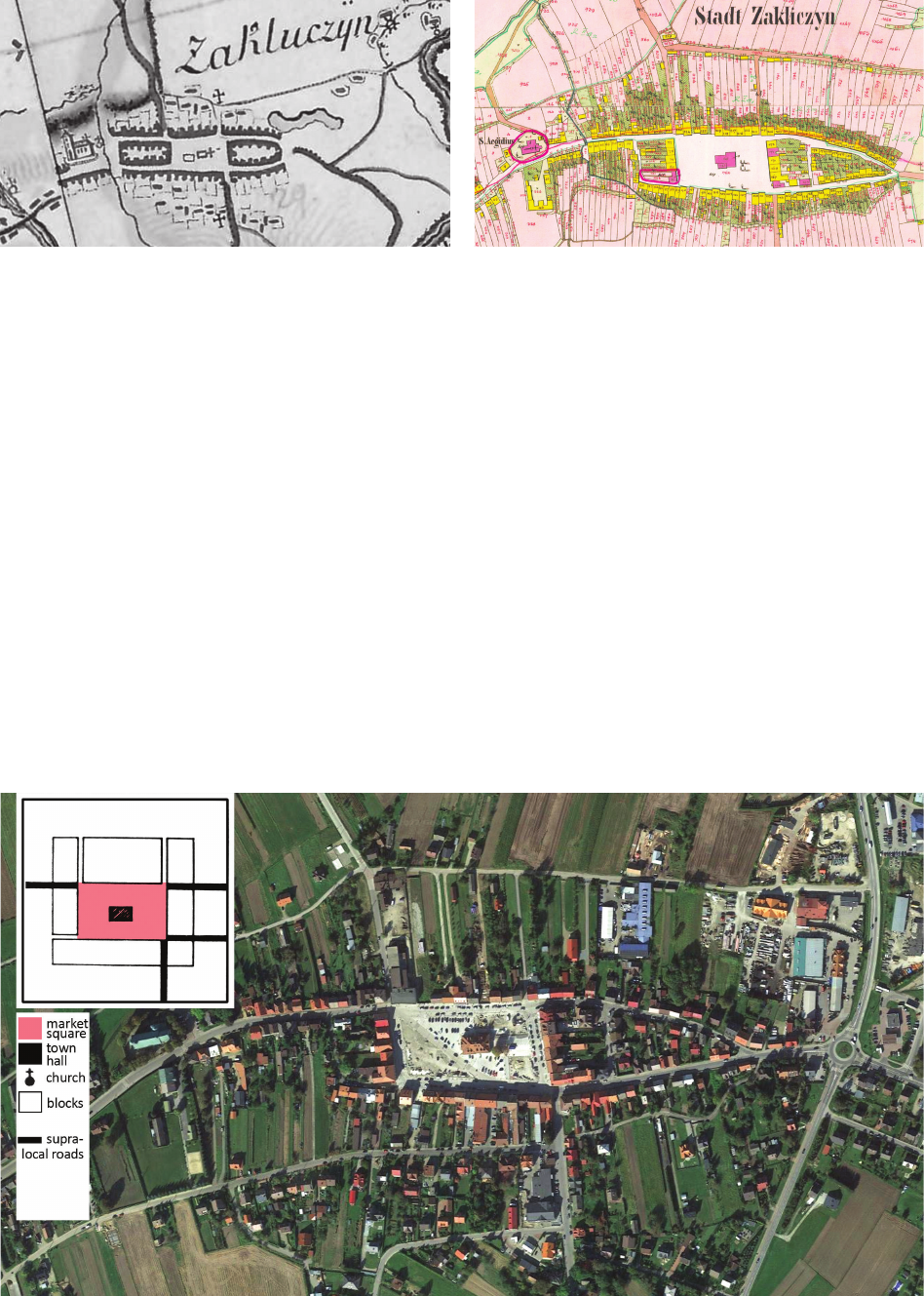
Zakliczyn’s urban layout was probably delineated based
on the short schnur unit of measurement, which was 37 m
long. At the center of the town, a rectangular market
square was delineated, measuring ca. 170 × 100 m. Sin-
gular town blocks were demarcated around the market
square. The northern block was markedly deeper than the
others, as here the settlement plots transitioned into elds
used by the settlers. This clearly indicates an agrarian use,
which, apart from commerce and crafts, was signicant
in Zakliczyn.
Circulation trails in Zakliczyn’s urban layout were based
on seven streets that extended from the market square, of
which three had primary signicance, while the others
were merely local streets (see Figs. 1–3).
The (originally wooden) parish church of St. Giles was
located outside of the urban layout as founded, which was
associated with its pre-founding age.
Zakliczyn changed owners several times. After the Jor-
dan family, it belonged to the Zborowski, Sobek, and Tarło
families. The latter were the founders of a monastery of
the Reformed Congregation of Friars Minor, which was
erected in 1622 [19].
The town, considering the previously discussed typology
of Renaissance towns established in historical Lesser Po-
land, represents the commercial type that acted as a mar-
ket for the region and surrounding villages that belonged to
the Jordan family. It should also be noted that Zakliczyn’s
plan allows us to classify it as a settlement delineated using
a traditional, medieval form of urban space organization.
A review of archival maps that feature Zakliczyn (the
First Military Survey – Map of Galicia and Lodomeria of
1769–1783, the Galician Cadaster of 1848, the Second Mil-
itary Survey – Map of Galicia and Bukovina from 1861–
1864) and up-to-date survey documentation of the town
indicated that its original urban layout, which emerged
during the period of its founding in the mid-16
th
century,
has mostly survived into the present. Its inarguable values
are evident in the fact that its urban layout is listed in the
register of monuments of the Lesser Poland Voivodeship
(entry no. A-21) based on a decision issued in 1976 [21].
Conservation of the Renaissance towns of Southern Poland based on selected examples: an introduction to research 85
Zakliczyn also has a local spatial development plan
(hereinafter: LSDP) in eect, which includes several stat-
utory conservation zones for its cultural heritage assets,
including the urban layout (strict conservation zone) [22].
The town was found not to possess an up-to-date his-
torical monument preservation program, which is unfortu-
nate, as such a document, the drafting of which every four
years is mandatory for a municipality, as stipulated in the
historical monument protection and preservation act [23],
supports local communities in revalorizing and preserving
local cultural heritage assets, procuring funding for this
purpose, and allows municipal planning and management
in the eld of monument protection and revalorization.
In summary, it can be concluded that the historical
urban structure of Zakliczyn, which has high historical
values due to its state of preservation, is under proper
conservation. This conservation is ensured by its listing
in the register of monuments, and is further enhanced by
the LSDP’s regulations. In this context, the need to draft
a municipal monument preservation program should be
noted, so that it can be used to support the local commu-
nity, including private owners, in the process of protecting
and revalorizing Zakliczyn’s monuments.
Fig. 1. Zakliczyn on the First Military Survey
– the Map of Galicia and Lodomeria in the years 1769–1783
(source: Archives of the Chair of the History of Architecture
and Monument Conservation of the FoA CUT
– Urban Planning Team, map photo)
Il. 1. Zakliczyn na I Zdjęciu Wojskowym,
Mapie Galicji i Lodomerii z lat 1769–1783
(źródło: Archiwum Katedry Historii Architektury
i Konserwacji Zabytków, WA PK
– Zespół Historii Urbanistyki, fot. mapy)
Fig. 2. Zakliczyn on the Galician Cadaster from 1848
(source: National Archives in Cracow,
sign. 29/280/0/2.1/310)
Il. 2. Zakliczyn na katastrze galicyjskim z 1848 r.
(źródło: Archiwum Narodowe w Krakowie,
sygn. 29/280/0/2.1/310)
Fig. 3. Zakliczyn on an up-to-date orthophotomap with a diagram of the town’s layout as founded
(map source: Google Earth, accessed: 4.06.2022; elaborated by D. Kuśnierz-Krupa, K. Kuśnierz)
Il. 3. Zakliczyn na aktualnej ortofotomapie wraz ze schematem rozplanowania miasta lokacyjnego
(źródło mapy: Google Earth, data dostępu: 4.06.2022; oprac.: D. Kuśnierz-Krupa, K. Kuśnierz)
86 Dominika Kuśnierz-Krupa, Kazimierz Kuśnierz, Małgorzata Hryniewicz, Julia Ivashko, Dorota Bober
Cieszanów
The second of the Renaissance towns of historical
Lesser Poland to be analyzed was Cieszanów – a town
founded along the Brusienka River. At present, the town is
located in the Subcarpathian Voivodeship, in Lubaczow-
ski County, and is the seat of an urban-rural municipality.
Cieszanów was established towards the end of the
16
th
cen tury, probably around 1590, as a private town found-
ed by Stanisław Cieszanowski of the coat of arms of Jelita,
starost of Sambor, close to a manorial and garden complex
in Nowe Sioło, a property of the Cieszanowski family. The
town’s location was associated with the course of a trade
route from Jarosław towards Lublin, and the contempora-
neous need to establish a town that, similarly to Zakliczyn,
would form a market for a complex of villages that be-
longed to the magnate family [9, pp. 80–85], [24]–[26].
The town was founded between two pre-existing vil-
lages. To the west of it was Wola Nowosielecka (previous-
ly known as Cieszanów and mentioned in sources already
in 1496 [27]), while to the west it was Nowe Sioło with
the estate and previously mentioned manorial and garden
complex owned by the Cieszanowski family.
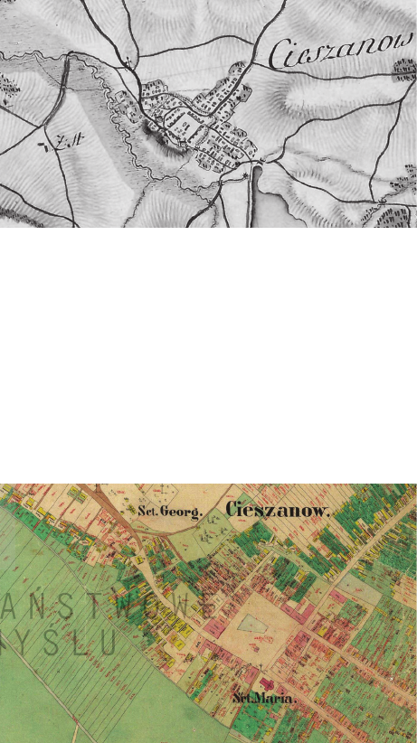
The town of Cieszanów was given a regular, orthogonal
urban layout, delineated using the long schnur measure-
ment unit (ca. 45 m), and a square-shaped market square
was delineated in its center, measuring 135 × 135 m (3 × 3
schnurs).
Around it, singular 1 schnur deep town blocks
were planned and divided into settlement plots with a prob-
able width of 13.5 m, which resulted in the original plan
featuring 50 settlement plots around the market square [9,
p. 73]. The diagonal blocks were probably slated for ad-
ditional development, acting as reserve land. Over time,
the diagonal block from the southeast of the market square
came to be occupied by the parish church, which was built
only towards the end of the 18
th
and the beginning of the
19
th
century. Beforehand, the function of the parish church
was performed by the church of St. Sophia, located to the
west of the Renaissance urban layout (at the site of a later
Orthodox church), and later the monastic church of the Or-
der of St. Dominic [26].
Soon after its completion, the town was given the func-
tional program devised by its founders, which included
residential and commercial development. North of the
regulated urban layout there stretched long farming plots,
to the east were urban gardens, while in the south was
the Brusienka River, with the “lordly elds” behind it (see
archival town plans, Figs. 4–6).
In 1665, Cieszanów was founded again. The town charter
was reissued by King Jan Kazimierz. The Renaissance for-
tications that used to encircle the town are probably from
this period [8, p. 130]. Their remains are visible to this day.
Over time, the town changed owners (in sequence, it
was owned by the Wierzbicki family, then Adam Lipski,
and later by the Bełżecki family) [24]–[27].
For over 400 years of its history, Cieszanów was af-
fected by numerous disasters like res or invasions by
foreign armies, such as those of the Tartars. However, the
town recovered each time and rebuilt at a varying pace.
In Cieszanów, the market square sported a town hall, and
there were also a mill, a canvas whitening shop, and a pa-
per mill there. Apart from Roman Catholic churches (and
a Dominican monastery), the town also featured a syna-
gogue and an Orthodox church.
Cieszanów, concerning the previously discussed ty-
pology of Renaissance towns, represents the commercial
center type.
An analysis of Cieszanów’s historical plans, namely
that of the First Military Survey – Map of Galicia and
Lodomeria of 1769–1783, the Galician Cadaster of 1848,
the Second Military Survey – Map of Galicia and Buko-
vina from 1861–1864, when confronted with an up-
to-date
survey map and an orthophotomap (Fig. 6) allows us to
state that, essentially, the Renaissance-period historical
urban layout of Cieszanów has survived into the present.
This observation concerns both the shape and size of the
market square and the development blocks around it, es-
pecially the western, northern and southern ones. It should
be noted that the fact that the town’s historical develop-
Fig. 4. Cieszanów on the First Military Survey
– Map of Galicia and Lodomeria of 1769–1783
(source: Archives of the Chair of the History of Architecture
and Monument Conservation of the FoA CUT
– Urban Planning Team, map photo)
Il. 4. Cieszanów na I Zdjęciu Wojskowym,
Mapie Galicji i Lodomerii z lat 1769–1783
(źródło: Archiwum Katedry Historii Architektury
i Konserwacji Zabytków, WA PK
– Zespół Historii Urbanistyki, fot. mapy)
Fig. 5. Cieszanów on the Galician Cadaster from 1854
(source: National Archives in Przemyśl, sign. 56/126/0/0/272M)
Il. 5. Cieszanów na katastrze galicyjskim z 1854 r.
(źródło: Archiwum Państwowe w Przemyślu, sygn. 56/126/0/0/272M)
Conservation of the Renaissance towns of Southern Poland based on selected examples: an introduction to research 87
ment (especially around the market square) did not survive
does not in itself aect the value of its historical urban lay-
out, which has survived almost unchanged into the pres-
ent. The fact that the urban layout had not been entered in
the Subcarpathian Voivodeship’s register of monuments is
all the more surprising in the light of this. Cieszanów does
not have an LSDP in place either, a measure that could
ensure the conservation of the historical urban layout. It is
nevertheless worth noting that the municipality has an up-
to-date monument preservation program, which includes,
among others, an overview of its assets and an analysis of
the condition of the municipality’s heritage and cultural
landscape, information about the assets’ statutory conser-
vation, and guidelines in this respect [28].
In summary, it should be highlighted that the historical
spatial structure of the town is not under any form of statu-
tory conservation, which can lead to its rapid destruction,
for instance due to remodeling the transport grid and the
construction or extension of the existing buildings located
within historical town blocks. Eorts should be made to
enact an LSDP that would place the urban layout in a strict
conservation zone as soon as possible, so that the layout
can be protected and new projects can be controlled by
the proper Voivodeship Monument Conservation Oce.
Raków
The last of the towns to be studied was Raków. A for-
mer urban municipality, it is currently a village located in
the Holy Cross Voivodeship, in Kielce County, and is the
seat of a municipality.
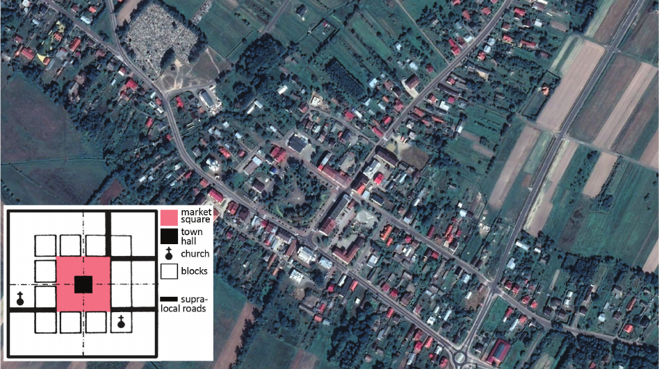
The town was founded by Jakub Sienieński of Sienno
on the Czarna, on a previously uninhabited piece of land
that had been rich in forests [29, p. 7]. Nearby there were
routes connecting Łagów and Stopnica through Szydłów,
and from Kielce to Staszów. They were nevertheless of no
signicant importance [30, p. 13].
The Sienieński family, as many other Polish magnate
families (e.g., the Jordan or the Cieszanowski families),
urbanized their estates. The result of this urbanization in
historical Lesser Poland was, among others, Raków, for
which the aforementioned Jan Sienieński issued a town
charter on May 27, 1567, with the approval of Sigismund II
Augustus, King of Poland [31].
Raków was founded based on the Magdeburg law.
Analysis of archival cartography, namely the First Mili-
tary Survey – Map of Eastern Galicia of 1801–1804, an
up-to-date cadastral map and an orthophotomap enabled
the hypothesis that the town had been delineated based on
the short schnur, with a length of 37 m, as well as that, in
the past – perhaps in search of plots for additional settlers,
who had been arriving in the town in droves towards the
end of the 16
th
and in the 17
th
centuries – another town
block had been added and delineated within the market
square’s space (from the west). Originally, the market
square had a shape similar to a square and measured ca.
148 × 148 m, namely 4 × 4 short schnurs. The market
square was surrounded by town blocks with a depth of
1 schnur, which were then divided into settlement plots.
This urban layout would feature diagonal town blocks that
would be also visible today, with 2 streets extending from
each of the market square’s corners (with the exception of
Fig. 6. Cieszanów on an up-to-date orthophotomap with a diagram of the town’s layout as founded
(map source: Google Earth, accessed: 4.06.2022; elaborated by D. Kuśnierz-Krupa, K. Kuśnierz)
Il. 6. Cieszanów na aktualnej ortofotomapie wraz ze schematem rozplanowania miasta lokacyjnego
(źródło mapy: Google Earth, data dostępu: 4.06.2022; oprac. D. Kuśnierz-Krupa, K. Kuśnierz)
88 Dominika Kuśnierz-Krupa, Kazimierz Kuśnierz, Małgorzata Hryniewicz, Julia Ivashko, Dorota Bober
of a triangle, was even delineated to the northeast of the
original urban layout.
It is worth noting that in 1599 Raków became an ocial
center of the Polish Brothers, a branch of Arians. Two years
later, synodal councils began to be hosted in Raków. During
this period, a school [33, p. 266], a printing shop [34, p. 26]
and slightly later also a town hall were erected there. In addi-
tion, the town was a commercial center with well-developed
commerce, crafts and agriculture. It featured grain mills,
breweries, a malt house and a glass mill [32, pp. 33–44].
In summary of the analyses presented, it should be stat-
ed that, in essence, Raków’s historical urban layout – with
clear characteristics of a commercial center in terms of
Polish Renaissance town typology – has survived into
the present. The only exception here is the structure of
the western block and the associated size of the market
square, which is currently a matter for further research.
The historical values of this layout had already been
acknowledged, as in 1984 the urban layout and the small-
town development of Raków were included in the register
of monuments of the Holy Cross Voivodeship (entry no.
A-453) [35].
Raków also has an LSDP in eect, in which the his-
torical layout has been covered by a cultural conservation
zone and a strict conservation zone [36].
Unfortunately, the municipality does not have a monu-
ment preservation program that could contribute to stop-
ping the degradation of monuments and lead to an improve-
ment of their state of preservation, while also dening the
conditions of cooperation with monument owners.
In summary, it should be highlighted that the historical
urban layout of Raków is suciently protected. The terri-
Fig. 7. Raków on the First Military Survey
– Map of Eastern Galicia of 1801–1804
(source: https://wbc.poznan.pl/dlibra/publication/538564/edition/479982,
accessed: 4.06.2022)
Il. 7. Raków na I Zdjęciu Wojskowym,
na Mapie Galicji Wschodniej z lat 1801–1804
(źródło: https://wbc.poznan.pl/dlibra/publication/538564/edition/479982,
data dostępu: 4.06.2022)
Fig. 8. Raków on an up-to-date orthophotomap with a diagram of the town’s plan as founded
(map source: Google Earth, accessed: 4.06.2022; elaborated by D. Kuśnierz-Krupa, M. Hryniewicz)
Il. 8. Raków na aktualnej ortofotomapie wraz ze schematem rozplanowania miasta lokacyjnego
(źródło mapy: Google Earth, data dostępu: 4.06.2022; oprac. D. Kuśnierz-Krupa, M. Hryniewicz)
the southeast corner). The street that extended from the
northwest corner would lead northwards to the no-lon-
ger-existing Arian prayer house, at the site of which the
Holy Trinity Church was built around the mid-17
th
centu-
ry [32] (see Figs. 7, 8).
The town did not possess Renaissance fortications,
and merely a wooden curtain wall with a system of ponds,
articial reservoirs and the Czarna River, along with two
gates and a smaller port. In the early 17
th
century, due to
a second wave of settlers, the town began to increase its
territory. The so-called New Market Square, in the shape
Conservation of the Renaissance towns of Southern Poland based on selected examples: an introduction to research 89
torial entry in the register of monuments is supported by
provisions of local law on the need to preserve this valu-
able historical structure. However, it is an oversight by the
municipal authorities that thus far no up-to-date municipal
monument preservation program has been drafted, a doc-
ument that could support and act as a “signpost” for the
local community, including the owners of historical build-
ings or those within the conservation zone, on the matter
of procuring funding for renovation and any needs arising
from the proper care over cultural heritage assets.
Conclusions
In conclusion, it should be noted that during the Re-
naissance it was mostly the magnates who took the lead
in establishing new cities and towns. The magnates saw in
this a means to gain wealth in a period of economic crisis.
A newly-founded town would become primarily a market
for products produced in a latifundium.
From the standpoint of urban design history and the
typology of Renaissance urban layouts, the towns an-
alyzed – Zakliczyn, Cieszanów and Raków – are com-
mercial centers founded by private owners (the Jordan,
Cieszanowski and Sienieński families). Their urban lay-
outs are well-dened, orthogonal structures measured
using old Polish units of measurement: Zakliczyn and
Raków using the short schnur (37 m) and Cieszanów us-
ing the long schnur (45 m). Large market squares were
delineated in the centers of the towns, which was aligned
with their main purposes, i.e. commerce and trade. The
market square in Zakliczyn is rectangular, while those of
Cieszanów and Raków are roughly square-shaped.
All three towns have urban layouts that have survived
until the present in a well-preserved state, and that were
delineated during the Renaissance, in the 2
nd
half of the
16
th
century to be exact. Despite this, only two of the spa-
tial structures (those of Zakliczyn and Raków) are listed
in the register of monuments. The same towns also have
LSDPs in eect, which have the historical centers placed
in strict conservation zones. They do not, how ever, pos-
sess up-to-date municipal monument preservation pro-
grams, despite the statutory duty to draft such a program
every four years. Drafting such a document is thus an es-
sential guideline for reinforcing and popularizing the need
for statutory conservation of cultural heritage among the
local community, concerning both urban planning and ar-
chitecture. The historical urban layout of Cieszanów is,
in contrast, not protected in any way, as it has been made
neither a part of a territorial entry in the register of mon-
uments nor has a strict conservation zone been imposed
upon it in an LSDP. The town nevertheless does have an
up-to-date municipal monument preservation program.
In this case, it is important to make eorts to enter this
valuable layout in the register of monuments of the Sub-
carpathian Voivodeship and to draw up an LSDP with cor-
rectly dened and delineated strict conservation zones for
the well-dened urban structure of the town as founded.
The cases above indicate that Renaissance urban plan-
ning heritage is still present and clearly legible in the cul-
tural space of Lesser Poland’s cities. What is more, heri-
tage is, to quote the Historical monument protection and
preservation act, a testament to an important period in Po-
land’s history (and contemporaneous tendencies in urban
design), and its preservation is in the public interest due
to unquestionable historical, artistic and academic values
[23], which has been demonstrated above.
Translated by
Krzysztof Barnaś
References
[1] Kłosek-Kozłowska D., Ochrona wartości kulturowych miast a urba-
nistyka, Ocyna Wydawnicza PW, Warszawa 2007.
[2] Sowała A., The history of the Sieradz’s Old Town hidden in the for-
mer Tatarczy Market Square, “Architectus” 2021, No. 2(66), 17–26,
doi: 10.37190/arc210202.
[3] Kuśnierz-Krupa D., Kobylarczyk J., Lisińska-Kuśnierz M., Kru-
pa M., Kuśnierz K., Typology of medieval urban layouts in historic
Lesser Poland and their protection, “Planning Perspectives” 2021,
Vol. 36, Iss. 4, 847–857, doi: 10.1080/02665433.2021.1927158.
[4] Kalinowski W., Miasta polskie w XVI i pierwszej połowie XVII w.,
“Kwartalnik Architektury i Urbanistyki” 1963, t. 8, nr 3/4, 167–225.
[5] Kalinowski W., Zarys historii budowy miast w Polsce do połowy XIX
wieku, UMK, Toruń 1966.
[6] Kowalczyk J., Ideologiczne aspekty urbanistyki Zamościa, [in:]
K. My śliński (red.), Zamość i Zamojszczyzna w dziejach i kulturze
polskiej, UMCS, Lublin 1969, 135–141.
[7] Książek M., Miasta prywatne Wiśnicz Nowy i Kolbuszowa (na tle
działalności urbanistyczno-architektonicznej Lubomirskich w XVII
wieku), PK, Kraków 1990.
[8] Książek M., Zagadnienia genezy rozplanowania i typologii miast
prywatnych XVI i XVII wieku w południowej Małopolsce, PK, Kra-
ków 1988.
[9] Kuśnierz K., Miejskie ośrodki gospodarcze wielkich latyfundiów
południowej Polski w XVI oraz XVII wieku, PK, Kraków 1989.
[10] Kuśnierz K., Sieniawa: historia rozwoju przestrzennego, IHAiKZ
PK, Kraków 2001.
[11] Kuśnierz K., Tarnobrzeg: historia rozwoju przestrzennego, PK,
Kraków 1999.
[12] Kuśnierz K., Directions of modern urban development in south-
eastern Poland. Origins, urban models, examples, “Wiadomości Kon-
serwatorskie/Journal of Heritage Conservation” 2015, 41, 99–106.
[13] Tołwiński T., Urbanistyka, t. 1. Budowa miasta w przeszłości, Wy-
dawnictwo Zakładu Urbanistyki PW, Warszawa 1947.
[14] Wróbel T., Zarys historii budowy miast, Zakład Narodowy im.
Ossolińskich, Wrocław 1971.
[15] Kłosek-Kozłowska D., Jezuickie przestrzenie baroku. Przekształ-
cenia strukturalne miast polskich na przełomie XVI i XVII wieku,
Ocyna Wydawnicza PW, Warszawa 2021.
[16] Zarębska T., Przemiany przestrzenne miast polskich w dobie rene-
sansu i baroku, [in:] A. Gieysztor, T. Rosłanowski (red.), Miasta
doby feudalnej w Europie Środkowo-Wschodniej. Przemiany spo-
łeczne a układy przestrzenne, PWN, Warszawa 1976, 217–230.
[17] Zimna-Kawecka K., Kuśnierz-Krupa D., Krupa M., Heritage of
(non-)existing cities – on the Polish examples of medieval Świecie
90 Dominika Kuśnierz-Krupa, Kazimierz Kuśnierz, Małgorzata Hryniewicz, Julia Ivashko, Dorota Bober
Abstract
Conservation of the Renaissance towns of Southern Poland based on selected examples: an introduction to research
This paper discusses the conservation of selected historical Renaissance urban layouts located in the Lesser Poland, Subcarpathian and Holy
Cross voivodeships. The objective of the study was to analyze previous research on the theory of Renaissance urban design theory in Poland, with
a particular emphasis on the areas in question, as well as the typology of the urban layouts founded during this period.
An analysis of urban layouts of selected small towns was performed, which also covered their current forms of statutory conservation. The degree
of preservation of the layouts’ historical structure was determined, and a proposal of general guidelines for their conservation was formulated.
Key words: Renaissance-period urban design, Zakliczyn, Cieszanów, Raków, conservation, revalorization
Streszczenie
Problematyka ochrony małych miast renesansowych południowej Polski na wybranych przykładach. Wstęp do badań
Artykuł dotyczy problematyki ochrony wybranych zabytkowych renesansowych układów urbanistycznych zlokalizowanych na terenie woje-
wództw: małopolskiego, podkarpackiego oraz świętokrzyskiego. Celem badań była analiza dotychczasowej wiedzy w zakresie teorii urbanistyki
renesansowej w Polsce, ze szczególnym uwzględnieniem przedmiotowego obszaru, a także typologii zakładanych w tym okresie układów urbani-
stycznych.
W pracy dokonano analizy układów urbanistycznych wybranych małych ośrodków miejskich, a także ich bieżącej ochrony konserwatorskiej.
Określono stopień zachowania ich historycznej struktury oraz przedstawiono propozycję ogólnych wytycznych w zakresie ochrony.
Słowa kluczowe: urbanistyka okresu renesansu, Zakliczyn, Cieszanów, Raków, ochrona, rewaloryzacja
and Renaissance Krasiczyn, “Muzeológia a kultúrne dedičstvo”
2021, Vol. 9, Iss. 3, 65–92, doi: 10.46284/mkd.2021.9.3.4.
[18] Słownik geograczny Królestwa Polskiego i innych krajów sło-
wiańskich, B. Chlebowski (red.), nakł. Filipa Sulimierskiego i Wła-
dysława Walewskiego, t. 14, Warszawa 1895.
[19] Mateszew S., Zarys dziejów powiatu brzeskiego do 1772 roku,
[in:] A. Hollanek (red.), Ziemia Brzeska, Wydawnictwo Artystycz -
no-Graczne, Kraków 1966, 25–27.
[20] Kiryk F., Rozwój urbanizacji Małopolski XIII–XVI w., Wydawnic-
two Naukowe WSP, Kraków 1985.
[21] Wykaz obiektów wpisanych do rejestru zabytków nieruchomych
województwa małopolskiego z uwzględnieniem podziału na powia-
ty i gminy, stan na luty 2022 r., Małopolski WUOZ, https://www.
wuoz.malopolska.pl/wp-content/uploads/2022/03/Rejestr-za-
bytk%C3%B3w-luty-2022-powiaty-1.pdf [accessed: 17.06.2022].
[22] Miejscowy Plan Zagospodarowania Przestrzennego Gminy Zakli-
czyn, http://sip.zakliczyn.pl/ [accessed: 17.06.2022].
[23] Ustawa z dnia 23 lipca 2003 r. o ochronie zabytków i opiece nad
zabytkami z późniejszymi zmianami, https://isap.sejm.gov.pl/isap.
nsf/download.xsp/WDU20031621568/U/D20031568Lj.pdf [ac-
cessed: 17.06.2022].
[24] Gajerski S.F., Historia Cieszanowa, “Rocznik Stowarzyszenia Mi-
łośników Jarosławia” 1962, [R. 3], 111–118.
[25] Gajerski S.F., Zarys dziejów Cieszanowa, Polskie Towarzystwo Hi-
storyczne – Oddział w Przemyślu, Przemyśl 1981.
[26] Słownik geograczny Królestwa Polskiego i innych krajów sło-
wiańskich, F. Sulimierski, B. Chlebowski. W. Walewski (red.), t. 1,
Warszawa 1895.
[27] Szabatowski M., Rys historyczny Cieszanowa, “Rocznik Ziemi Lu-
ba czowskiej” 1971, t. 2, 73–79.
[28] Gminny program opieki nad zabytkami Miasta i Gminy Cieszanów
na lata 2020–2023, Załącznik nr 1 do Uchwały Nr XXI/173/2020
Rady Miejskiej w Cieszanowie z dnia 28 lutego 2020 r., https://
www.bip.cieszanow.akcessnet.net/index.php?job=wiad&id-
g=3&id=1618&x=77&y=0&n_id=4241 [accessed: 15.06.2022].
[29] Urban W., Raków. Szkic wstępny, [in:] Gmina Raków w publika-
cjach. Zestawienie bibliograczne, Biblioteka Publiczna w Kiel-
cach, Kielce 1999.
[30] Malanowicz S., Zabudowa Miasta Rakowa w XVII i XVIII wieku,
[in:] S. Cynarski (red.), Raków. Ognisko arianizmu, PWN, Kraków
1968.
[31] Słownik geograczny Królestwa Polskiego i innych krajów sło-
wiańskich, B. Chlebowski, W. Walewski (red.), nakł. Filipa Suli-
mierskiego i Władysława Walewskiego, t. 10, Warszawa 1888.
[32] Raków. Ognisko arianizmu, S. Cynarski (red.), PWN, Kraków
1968.
[33] Drzymała K., Bracia polscy zwani arianami, “Studia Theologica
Varsaviensia” 1963, t. 1, nr 2, 241–306.
[34] Pamiętnik Koła Kielczan, t. 7 (1936–1937), Wydane Nakładem
Koła Kielczan, Kielce–Warszawa 1937.
[35] Rejestr zabytków nieruchomych województwa świętokrzyskiego,
https://www.wuoz.kielce.pl//container/2021/rejestr%20zabyt-
kow%20nieruchomych%20-%20czerwiec%202021.pdf [accessed:
22.06.2022].
[36] Miejscowy Plan Zagospodarowania Przestrzennego Gminy Raków,
Uchwała nr XI/66/2015 Rady Gminy Raków z dnia 17 lipca 2015 r.
https://bip.rakow.pl/zagospodarowanie-przestrzenne/miejscowy-
plan-zagospodarowania-przestrzennego/2862-uchwala-nr-xi-66-
2015-rady-gminy-rakow-z-dnia-17-lipca-2015-r.html [accessed:
22.06.2022].